Skip to content

Tahoe Backcountry Snow

  • Summer 2026 Forecasting JournalSeasonal forecasting narrative and journal.
  • Current Wx. at 7650′Current weather station info at 6350′ in Carnelian Bay.
  • About
  • Glossary of Terms
  • Archive
  • Under the heat lamp

    March 17th, 2026

    Backcountry obs.:

    The great winter heatwave of 2026 is upon us. Touring inbounds at Diamond Peak at dawn on 3/16, surface snow had barely refrozen near the base area in a protected drainage thanks to overnight inversions. Moving up mountain, snow quickly softened and temps climbed starting around 7000′ and continuing to the summit at 8540′. Light easterly winds and temps in the low 40s greeted me at the summit where snow had barely cooled enough for a weak, surface refirm.

    This morning (3/17), low temps and dew points failed to refreeze surface snow, even with evaporational cooling high in the backcountry above 9000′. Temps atop Slide Mountain (9600′) only bottomed out at 46.2°F around 0400. This temperature coupled with 46% RH just wasn’t enough for snow grains to cool and refreeze on their own. It’s March 17 and even at the highest elevations in Tahoe, the snowpack is melting day and night.

    As such, expect warm, soft, and slushy snow throughout the backcountry for the foreseeable future. Even after the heat wave’s peak, temps will still be well-above normal, slowing the big melt only marginally. For many backcountry zones between 7000-8500′ where the snowpack was already thin, this event will likely draw a close to the 2026 snow season.

    Weather and forecast thoughts:

    Sunshine, light winds, and unprecedented warmth will continue through the week and into the early part of this coming weekend, likely peaking on Thurs (3/19). This weekend (3/21-22), the extreme, record-breaking heat fades into much above average warmth (10-15°F above normal) lasting through at least the first half of next week. Beyond next week, some models hint at the return of light precipitation returning, but confidence is low.

    This afternoon (3/17) temps reached the low 70s in Martis Valley with mid-upper 60s between 6000′-7000′. In the Tahoe Basin within 100-200ft of lake level, temps remained a bit cooler, only reaching the low 60s due to the cooling influence of Lake Tahoe’s winter-chilled waters. Temps for the remainder of the week will climb even higher reaching the low 70s near and below 7000′ Weds – Fri (3/18-3/20). Temps may remain a few degrees lower near the lake due to the lake’s aforementioned cooling effect.

    Lows throughout the week will remain above freezing all the way up to the highest backcountry locations, preventing surface refreezes. Where snowpack remains, it will likely turn isothermal (uniformly 0°C from surface to ground level). Wet snow instabilities and rockfall will become common, especially on sunny aspects and around cliff features each afternoon.

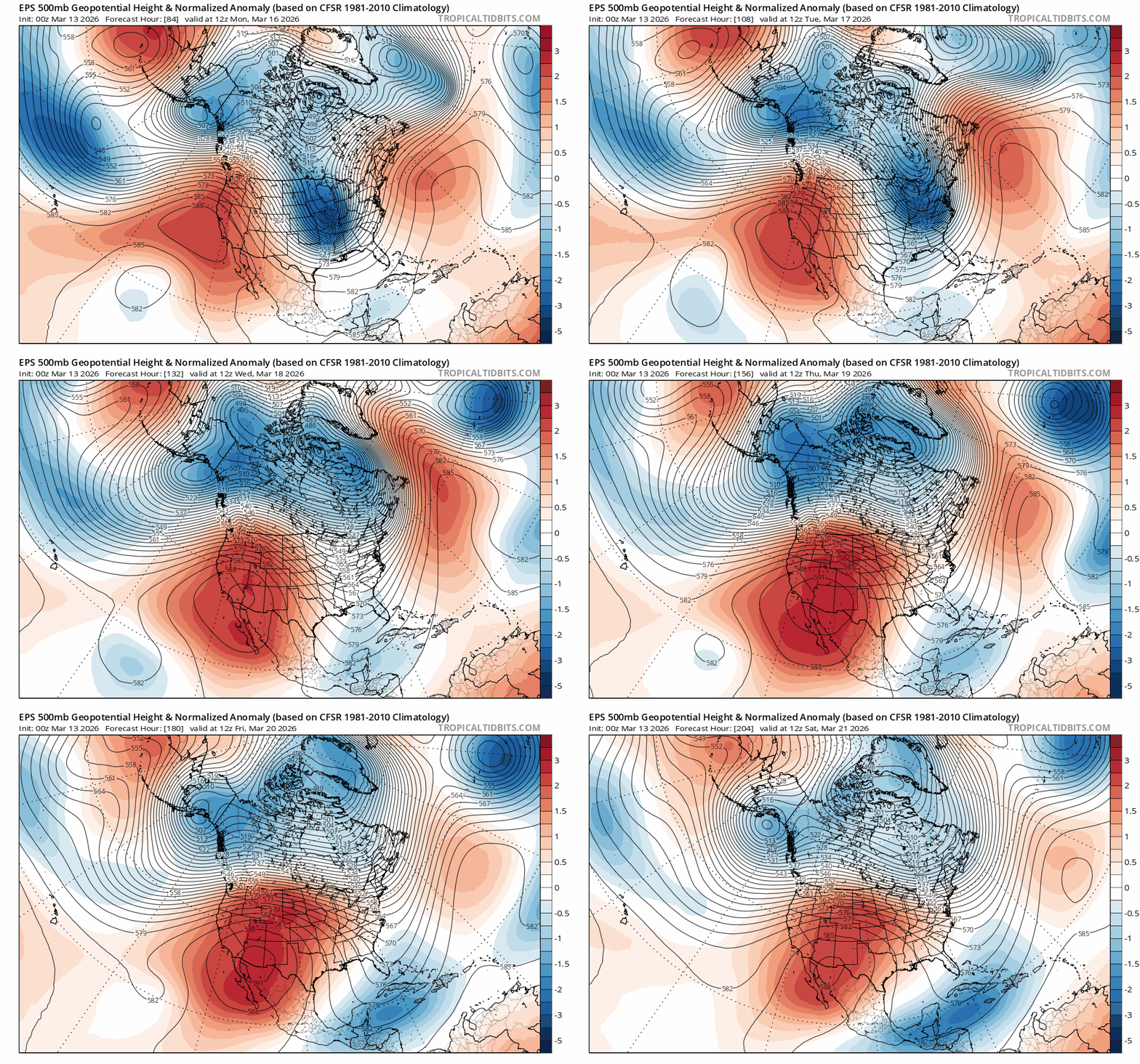
    As advertised, the cause of the anomalous warmth is a large, nearly stationary ridge of high pressure that’s creating a summer-like heat dome effect over the American West. As air sinks beneath the high, it dries out and heats up via subsidence, baking away the Sierra snowpack in the process.
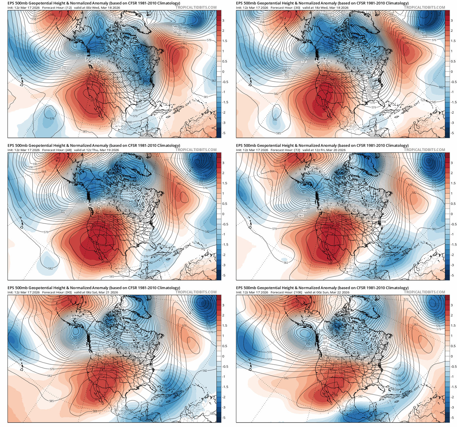
    EPS ensemble 500mb normalized height anomalies from 1700 PST on 3/17 – 1700 PST on 3/21 showing the highly anomalous (top of the charts) values for the high pressure.

    To get a sense of how warm this airmass actually is throughout the atmosphere, check out the ensemble models for freezing levels in the Tahoe Basin. Even the coolest models keep freezing levels above 12,000′ until Sun morning (3/22).
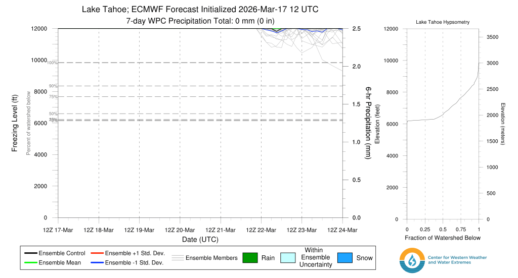
    ECMWF freezing level ensemble forecast for the Tahoe Basin 3/17 – 3/24.

    Is there any escape at the highest elevations? No. Even the highest elevations in the Sierra will not escape the summer-like heat. Freezing level forecasts for the Owens River watershed, which includes the Eastern High Sierra from the Palisades to Mt. Whitney, keep temps above freezing even above 14,000′ through at least Sat (3/21).
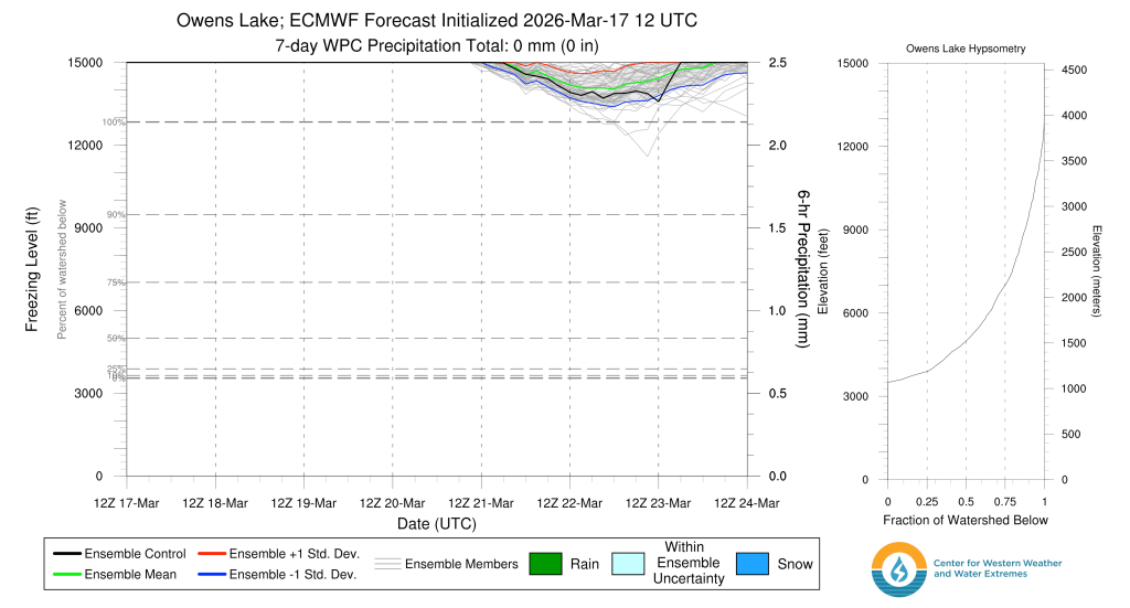
    ECMWF freezing level ensemble forecast for the Owens Lake watershed (Eastern High Sierra) from 3/17 – 3/24.

    While the Southern Sierra’s high elevations helped it to fare better through the 2026 snow drought–some areas above 10k ft. received near to slightly above average snowpacks going into March–this week’s warmth will rapidly accelerate melt and promote widespread wet snow avalanches and rockfall, especially in couloirs and along rock faces. I anticipate many High Sierra lines being cleaned out and/or littered with rockfall after this week.

    Peering ahead into the coming week and into the start of April, models suggest above average temps retaining the upper hand across the Sierra through the 27th, but to a less extreme degree, with some signs of precip reentering the picture. Relief is a long way off.

    So grab your bike, running shoes, or whatever else brings you joy in the warm months. There’s still plenty of fun to be had in the backcountry without sliding on snow.
    Share this:

    • Share on Reddit (Opens in new window) Reddit
    • Email a link to a friend (Opens in new window) Email
  • Big heat inbound and time running out

    March 13th, 2026

    Backcountry obs.:

    This has been the week of the corn cycle. Warm sunny days and nights just cool and dry enough to refreeze the snowpack have thrust the backcountry season into peak spring skiing.

    I poked around the NE corner of the Basin at dawn on Tues and Thurs (3/10 & 3/12) and found the usable snow line quickly retreating up to near 8000′, especially on S and W aspects. The snowline on N and E aspects is around 1000′ lower.

    Inversions have been setting up each night pulling lows near freezing at lake level–and a few degrees below in valleys and hollows away from the warming influence of the lake–while upper elevations have only bottomed out in the upper 30s to low 40s.

    Despite the warm lows in the mountains, clear skies, light breezes, and very dry air have helped to refreeze snow surfaces via evaporational and radiational cooling. Because of this setup, mid elevation, forested zones haven’t been refreezing well as radiation from the snow and trees gets reflected back onto the snow surface, heating the snow just enough to inhibit the refreeze. However, open areas with a clear line of sight to space have consistently refrozen each night, providing a supportable, frozen surface to climb early in the morning.

    Superficial refreezes demand alpine starts for the best skiing. Early morning sun has been baking E aspects as soon as the first rays touch the snow, softening frozen surfaces into smooth, buttery corn by mid morning. Beyond 10am, intense sun angles and high temps have begun overcooking snow surfaces into wet mush. It’s all about timing.

    Weather and forecast thoughts:

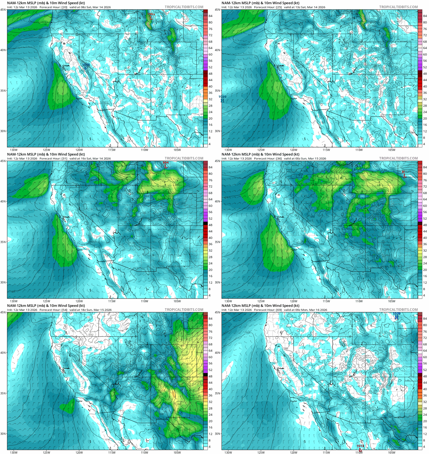
    Warm and dry weather will continue for the foreseeable future with no real prospects for snow through at least the next 10 days. This weekend (3/14-3/15), a weak cold front will bring an uptick to winds and cool daytime highs by a few degrees from their peaks yesterday and today (3/12-3/13). Even with the cool down, temps will still be 10-15 degrees above average for mid March. (Average highs in Tahoe City this weekend are around 45°F). Expect highs in the backcountry above 7000′ in the low 50s both Sat and Sun with occasional high clouds streaming across the area.

    Light to moderate winds from the west on Sat (3/14) will shift around to the N and NE on Sun (3/15) bringing a subtle chill to the air, likely delaying the daily surface melt. If any clouds do end up lingering about overnight, they could keep temps a bit higher, thus inhibiting or blunting the strength of the nightly refreeze.

    NAM 10m wind forecast from 0100 PDT on Sat, 3/14 to 0100 PDT on Mon, 3/16.

    Warm, dry weather continues and intensifies into the coming week (3/16-3/20) with heat reaching all time record highs for mid March. By mid-late week, high temps in the Tahoe Basin could flirt with or surpass 70°F on consecutive days! Despite the clear skies and dry air, lows, even on the snowpack, are unlikely to fall below freezing each night, putting an end to the current corn cycle and dealing a major blow to the remaining snowpack.

    Looking at the climatologically normalized pressure anomalies, ensembles are in good agreement that this event will likely crush records for March heat across the region. These maps show just how anomalous the pattern will be compared to average. This coming week will fall within or above the 95th percentile. That’s big high pressure!

    Euro ensemble 500mb heights and norm. anomaly from 0500 PDT on 3/16 – 0500 PDT on 3/21.

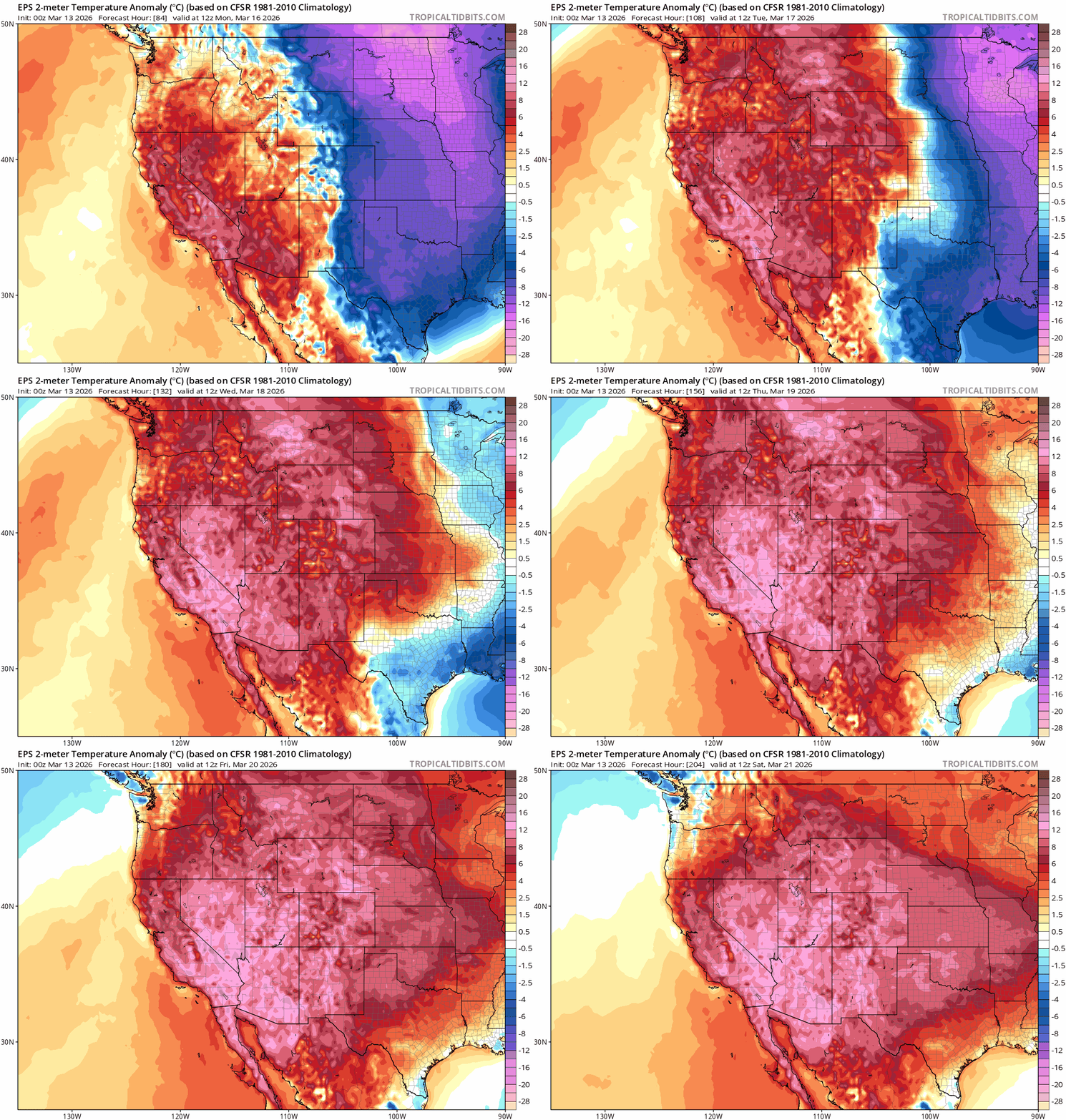
    And because high pressure causes the air mass to sink and heat as it descends, the strength of the high correlates to the strength of the heat it generates. Temp. anomalies across the SW will be at the top of the charts for the coming week with highs more akin to early summer than the last full week of winter.

    EPS ensemble 2m temp. anomalies from 0500 PDT on 3/16 – 0500 PDT on 3/21.

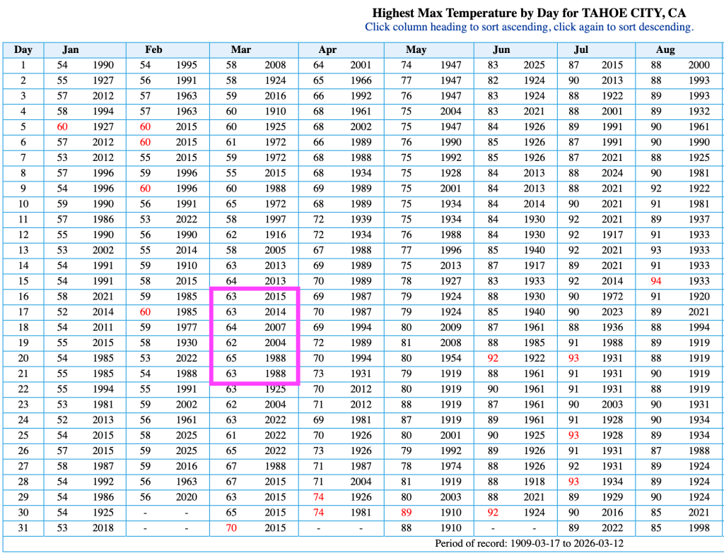
    Taking a look at climatology at Tahoe City, highs near or just above 70°F would far surpass current records for the middle of March, which are in the low to mid 60s. And surpassing 70°F would set a new all time record high for the entire month, last set on 3/31/15.

    Record high temps at Tahoe City dating back to 1909 as recorded by NOAA/NWS.

    There’s no escape from heat of this magnitude. Even the highest, most protected zones of the Tahoe backcountry will get cooked.

    Peering way out beyond next week, warm and dry signals continue into third week of March. More warmth after such an extreme heat event on a below average snowpack may spell the end of the 2026 season for most Tahoe locations.

    Now, more than ever, it’s time get what’s left and enjoy the remaining days of the current corn cycle and backcountry season.

    Share this:

    • Share on Reddit (Opens in new window) Reddit
    • Email a link to a friend (Opens in new window) Email
  • Corn: get it before it’s gone

    March 8th, 2026

    Backcountry obs.:

    Despite the apparent end to winter 6 weeks ahead of schedule, there’s still plenty of great snow to be had at upper elevations if you shift your expectations from powder to corn. In addition to being known for big dumps, Sierra skiing’s number two claim to fame is spring corn, and right now there’s plenty of it ripe for the taking.

    Recent cooler weather and dry NE flow has refrozen and tempered the rapid melt of late February. A tour above Incline Village on 3/8 revealed firmly refrozen melt-freeze surfaces from 7400-9600′ on all aspects. At dawn, southerly aspects hosted edgeable, supportable, refrozen corn that began softening in direct sun by 0800. By mid morning, southerly aspects skied fast and creamy: quite frankly some of the best and most enjoyable skiing of the season.

    Get it while it’s here. The snow pack is quickly melting away. Below 8000′ patches of dirt and pine needles made for tricky route finding and occasional log hopping. Even at higher elevations, tree wells now show rocks and dirt as the snow slinks away ever more with each passing day.

    Weather and forecast thoughts:

    Well above average temps and dry weather will dominate the coming week (3/9-3/15), further hastening the demise of the 2026 snowpack. Highs look to reach the upper 40s to low-mid 50s above 7000′, especially around midweek and into the coming weekend. Inversions return each night with lows in valleys and depressions dropping to near or just below freezing, while upper elevations remain well above freezing. Upper elevation snow surfaces should refreeze through midweek due to evaporational cooling in the drier, high elevation air. Warmer air arrives towards the end of the week likely signaling weaker refreezes, if at all.

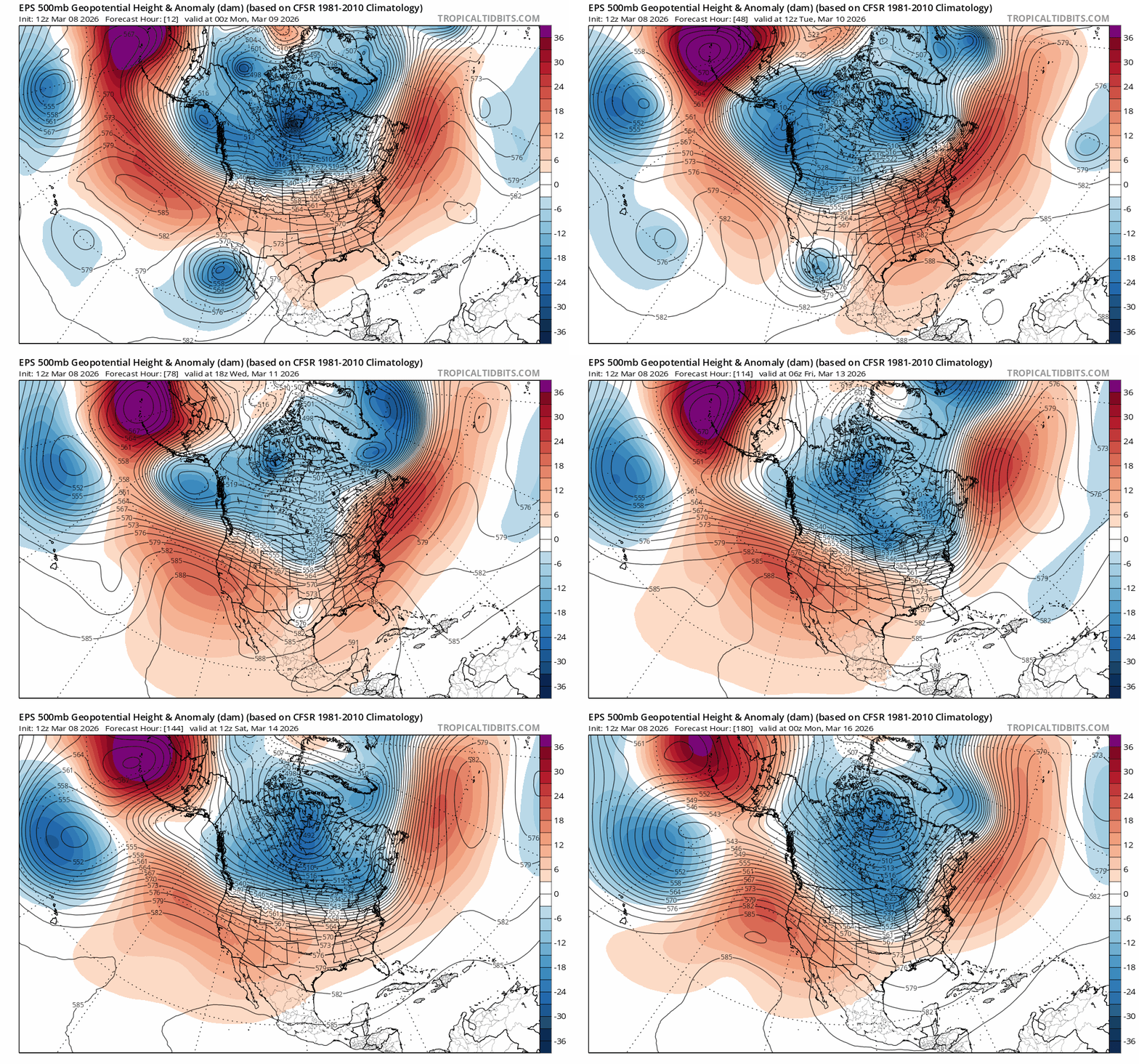
    The culprit is the return of the big, blocking ridge over the eastern Pacific. This time it’s positioning itself in a prime spot to deflect any moisture and cooler weather north into the PacNW.

    EPS 500mb height anomalies from 3/8 at 1700 – 3/15 at 1700.

    The low responsible for cooler, NE flow at the end of last week will eject off to the east via Mexico by the middle of the week, taking any northerly flow along with it.

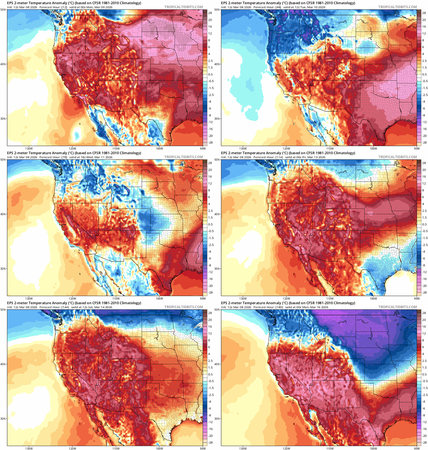
    As a result, temps will warm to well above average yet again, as noted by 2m temp anomalies from 3/8-3/15.

    EPS 2m temp anomalies from 3/8-3/15.

    With a flimsy existing snowpack and higher spring sun angles, this renewed bout of well-above average temps will quickly degrade the Tahoe backcountry snowpack. Higher elevation zones above 8500′ on cooler, more-protected aspects will fair be better, but there’s really no escaping the melt, especially when temps don’t recover below freezing each night. Even if cold and stormy weather returns for the latter half of March, snow will likely fall on bare ground in all but the highest elevation zones, as most of the existing base will have melted off.

    Now’s the time to harvest whatever spring turns are out there. There will be more today than tomorrow. Carpe diem.

    Share this:

    • Share on Reddit (Opens in new window) Reddit
    • Email a link to a friend (Opens in new window) Email
←Previous Page
1 2 3 4 5 6 … 53
Next Page→

Create a website or blog at WordPress.com

Loading Comments...
  • Subscribe Subscribed
    • Tahoe Backcountry Snow
    • Already have a WordPress.com account? Log in now.
    • Tahoe Backcountry Snow
    • Subscribe Subscribed
    • Sign up
    • Log in
    • Report this content
    • View site in Reader
    • Manage subscriptions
    • Collapse this bar