Skip to content

Tahoe Backcountry Snow

  • Winter 25-26 Forecasting JournalSeasonal forecasting narrative and journal.
  • Current Wx. at 7650′Current weather station info at 6350′ in Carnelian Bay.
  • About
  • Glossary of Terms
  • Archive
  • Another spring refresh

    April 21st, 2026

    Backcountry obs.:

    Cool nights, sunny days and occasional winds helped promote excellent spring skiing across the highest Tahoe backcountry zones this past weekend (4/17-19).  Heading out at dawn on 4/19, I found mostly supportable melt-freeze conditions across the majority of aspects above 8600′ in the Mt. Rose backcountry. Transitional, yet frozen winter snow, adorned with breakable crusts, topped the snowpack in high north facing bowls above 9000′. Well-frozen spring corn at various degrees of development blanketed the rest of the backcountry on E-S-W aspects. High clouds and a 10-20 knot SW wind slowed surface melt until mid-late morning on Sun (4/19) when clouds dissipated, and the sun finally got to work softening surface snow. 

    Popular zones are heavily tracked with multiple skin tracks and deep ruts left behind from late day skiers sinking deep in water-logged snow, while untracked, clean surfaces are more common than not further afield. A refresh would be nice.

    Wx. and forecast thoughts: 

    A deep, closed low inching its way into northern CA today will deliver the desired refresh to keep backcountry season going.  Today (4/21) rain and snow showers will increase in coverage and intensity during the day and into tonight, potentially dropping up to a foot+ of new snow along the Sierra Crest and highest terrain by dawn Weds (4/22). Snow levels will start around 7000′ at daybreak today, then fall to lake level and below by this afternoon. East of the crest and below 7000′, expect a nuisance few inches for most Tahoe communities. Behind today’s system, cool temps and sunshine return to the area for Weds into Thurs (4/22-4/23), before temps warm to near average for Fri and the weekend with renewed chances for isolated showers across higher terrain.

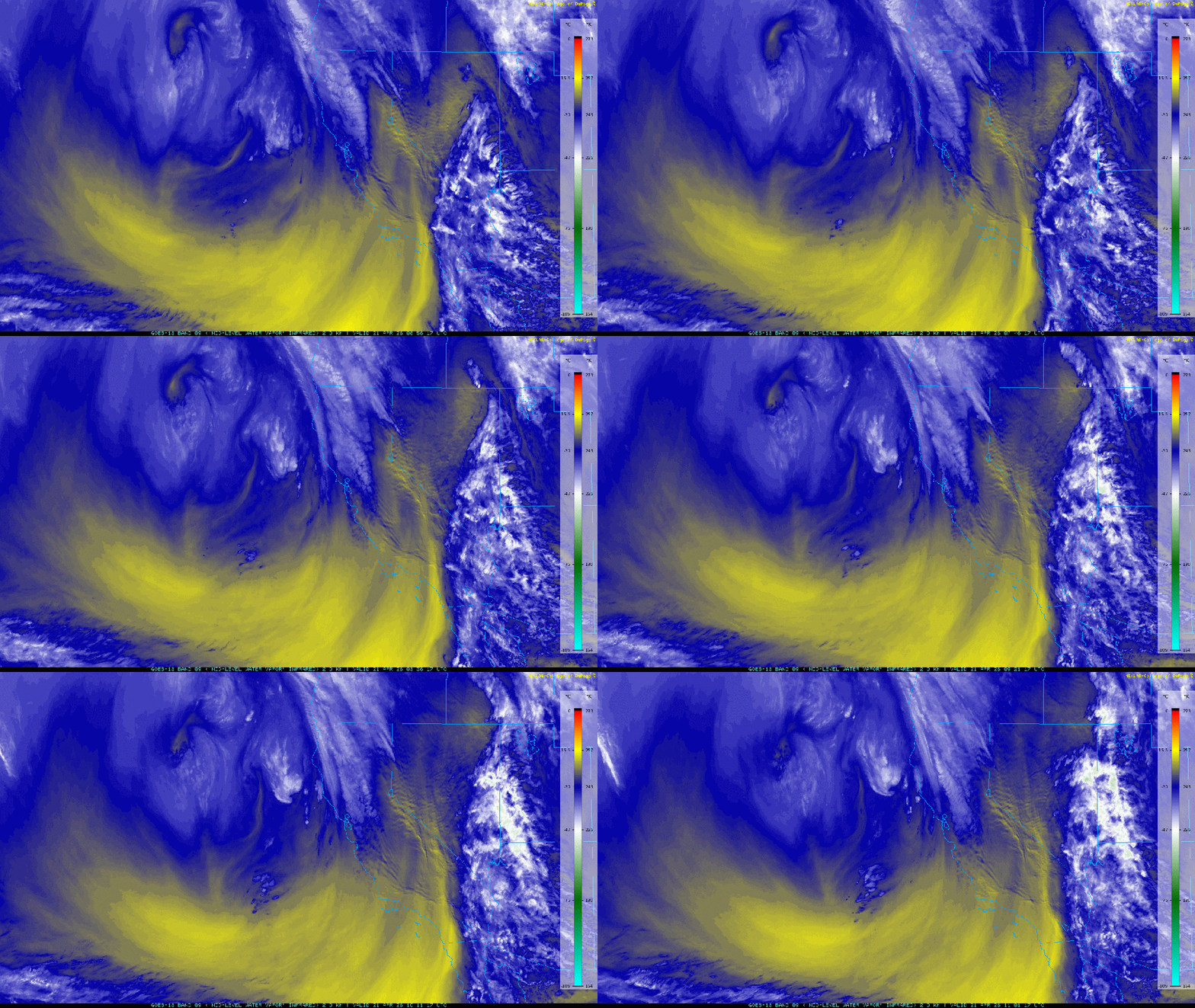
    IR mid-level water vapor satellite imagery this morning shows the storm spinning away and slowly advancing towards the Sierra. (Blues and whites denote greater moisture whereas yellow signifies drier air.)

    Mid level IR water vapor imagery from 12:00 AM PDT to 4:00 PDT on 4/21.

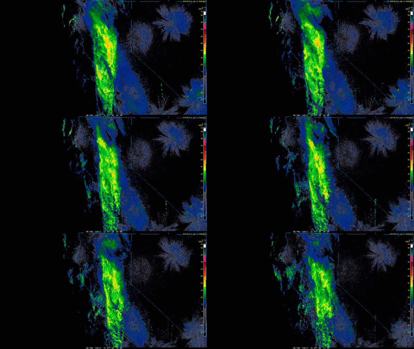
    And underneath those clouds and moisture, a north-south band of concentrated precip is nudging its way into the Sierra.

    Radar imagery from 12:10AM PDT to 4:10AM PDT on 4/21.

    Worth noting is the N-S flow in both images this morning. This wind flow isn’t conducive to efficient spillover east of the Sierra Crest because it’s hitting the Sierra at an oblique angle, rather than closer to 90°. Expect rain and snow to “hang up” on the crest before finally moving in later this morning.

    Throughout the day, the storm will edge eastward into Tahoe, bringing rounds of rain and snow into the mountains with snow levels falling throughout the day. Precip rates will likely increase later today as afternoon warmth and peak dynamics of the low combine, embedding convective showers and thunderstorms into the mix, especially near the Sierra Crest.  Afternoon instability will also promote thunderstorms to fire across the Central Valley (some potentially severe), then push eastward into the mountains, bringing locally heavy bursts of snow and pellet showers.

    Tonight snow showers will continue before tapering off around daybreak tomorrow (4/22) as the bulk of the moisture and dynamics moves eastward. Lingering instability will likely create a buildup of clouds and occasional snow/pellet showers throughout the day on Weds, before clearing out Weds night. Temps on Weds. will range from the upper 20s-mid 30s above 8000′, before cooling off into the low 20s on Weds night.

    High resolution models indicate highly variable total precip amounts due to the convective nature of this system, in addition to the S-N flow favoring areas along and west of the Sierra Crest. Notice the steep drop off in precip in this morning’s HRRR model for total liquid precip through late Weds afternoon.

    HRRR total storm precip through 1700 PDT on 4/22.

    Snow conditions in the backcountry will rapidly change throughout the storm and immediately thereafter in the dynamic spring environment. Cold powder on Weds AM will quickly warm and transition to mashed potatoes and “hot pow” on all but the shadiest north aspects throughout the day. Once the sun sets on Weds, any sun-softened snow will quickly refreeze into breakable crusts by Thurs AM, initiating the melt-freeze cycle and journey back to corn snow. 

    Thurs (4/23) looks to be cool and largely sunny with highs above 8000′ ranging between the upper 30s to mid 40s depending on elevation. Lows Thurs night will drop well below freezing under mainly clear skies. Inversions may develop, but the return of dry air and clearer skies will promote overnight refreezes and potentially, another weekend corn cycle. 

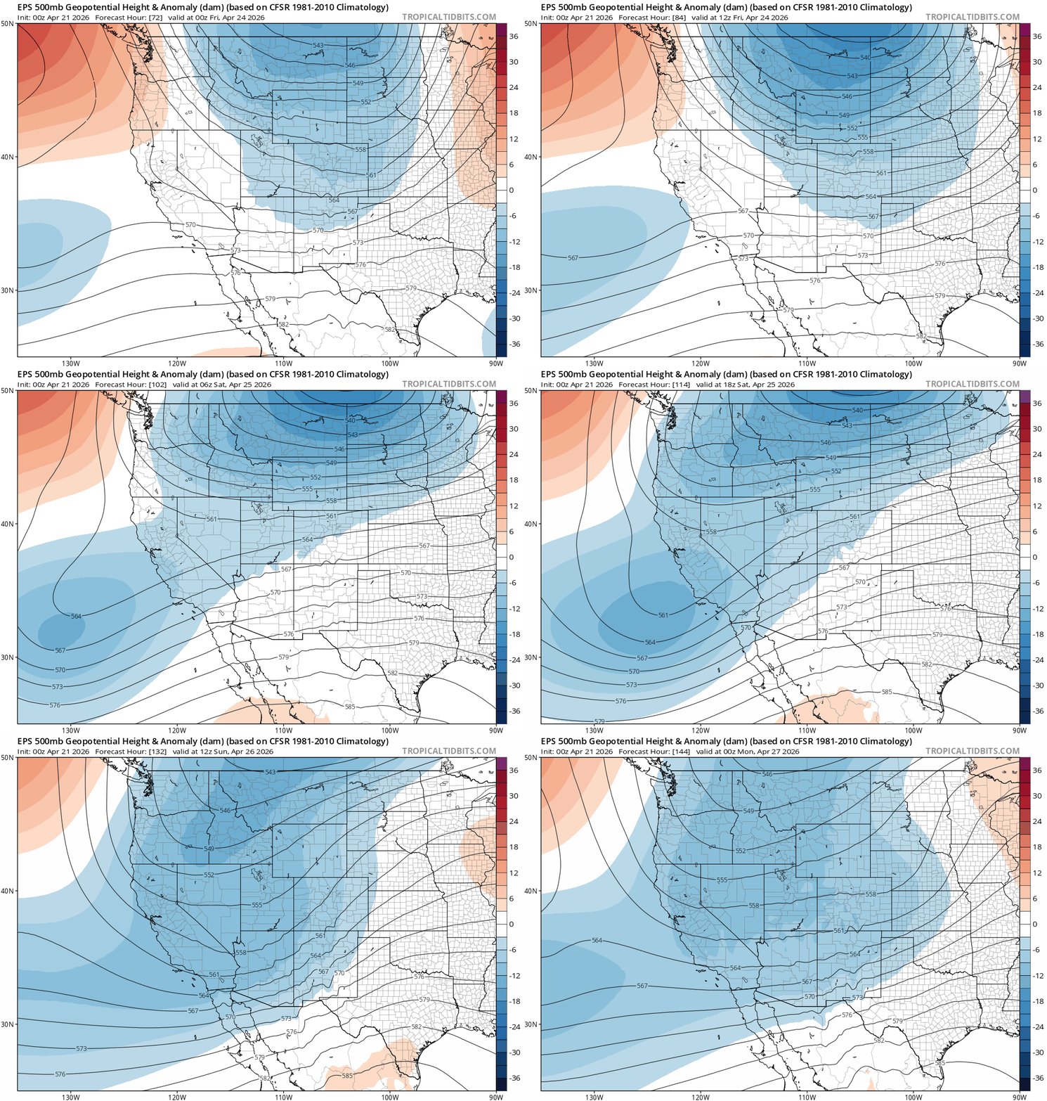
    For the coming weekend, model ensembles suggest the potential for more unsettled spring weather starting on Fri and lasting through Sun (4/24-4/26) as a trough of low pressure develops over the west.

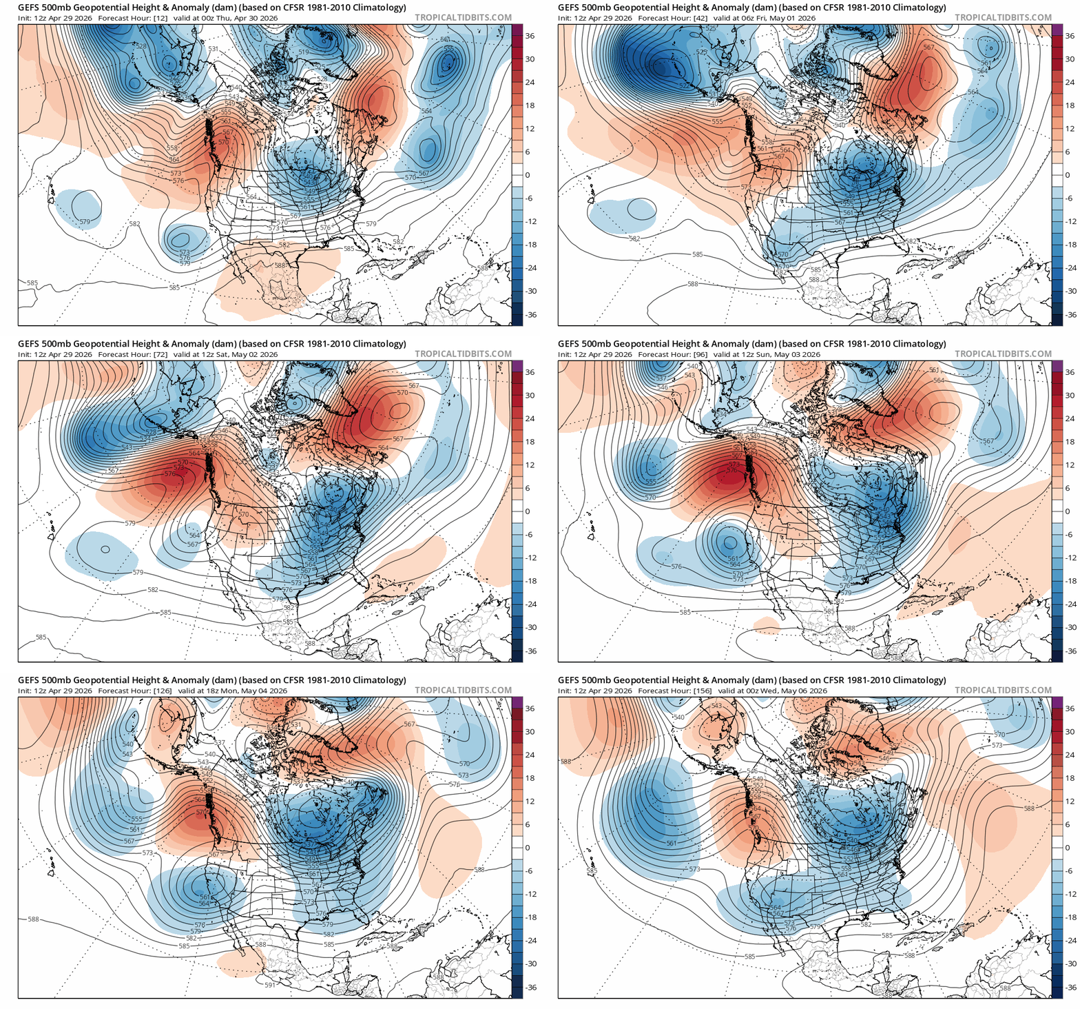
    EPS ensemble 500mb height anomalies from 5:00 PM Thurs, 4/23 – 5:00 PM Sun, 4/24.

    While confidence in any given outcome is low, chances for showers over the mountains and near to below normal temperatures in the 30s and 40s above 8000′ looks like a good bet the upcoming weekend.

    Despite a lackluster winter and low tide conditions this spring, the corn cycle is on and about to get another refresh. Backcountry season chugs on.

    Share this:

    • Share on Reddit (Opens in new window) Reddit
    • Email a link to a friend (Opens in new window) Email
  • “I’m not dead yet”: Backcountry season hangs on.

    April 16th, 2026

    NOTE: Since most of the snowpack melted away in March, I’ve taken a breather from the site to attend to life: family, vacation, and completing my forecasting certification from Penn State. Posts may be more intermittent in the near term, but will likely pick up again later in the spring as my focus shifts from snow to summer mountain weather.

    Backcountry obs.:

    Lo and behold, despite a few sharks emerging from the depleted base, backcountry season holds on in the Mt. Rose area, with plenty of help from the recent multi-foot storm from 4/11-4/13. Touring from 8650′ to 9950′ at dawn on 4/15, revealed a transitional spring snowpack with everything from crust to powder. Below 9300′, differing varieties of sun crusts from supportable, soon-to-be corn, to breakable but nearly-unturnable death crust, covered all aspects. Higher up, winter snow and fluffy powder greeted this curious skier dropping into a north facing bowl at sunrise. Smiles quickly followed. However, once at lower elevations, navigating breakable crust made returning to the car without injury a more tenuous pursuit.

    Worth noting is that despite the recent cold temps and cloud cover, the high April sun quickly transitions new snow from cold fluff, into baked mashed potatoes, to melt-freeze crusts on all but the most northerly aspects within a day or so. As long as there are refreezes, solar aspects transition to corn within a few days. As more snow falls in the next few weeks, expect conditions to change quickly. Timing will remain crucial to finding desired conditions.

    Weather and forecast thoughts:

    Things are moving again. The “stuck” pattern of persistent high pressure in the west and a trough in the east, so common this past winter, has been replaced by a transient and progressive parade of storms impacting the Sierra. For the latter half of April, ensembles agree on a mix of deep wandering low pressure systems and transient high pressure bringing fickle spring weather: periods of snow, rain, and wind interspersed with cool and sunny days. Even though the tide of the snowpack is in its inevitable retreat, occasional systems will likely add periodic refreshes over the High Sierra, slowing the outgoing tide.

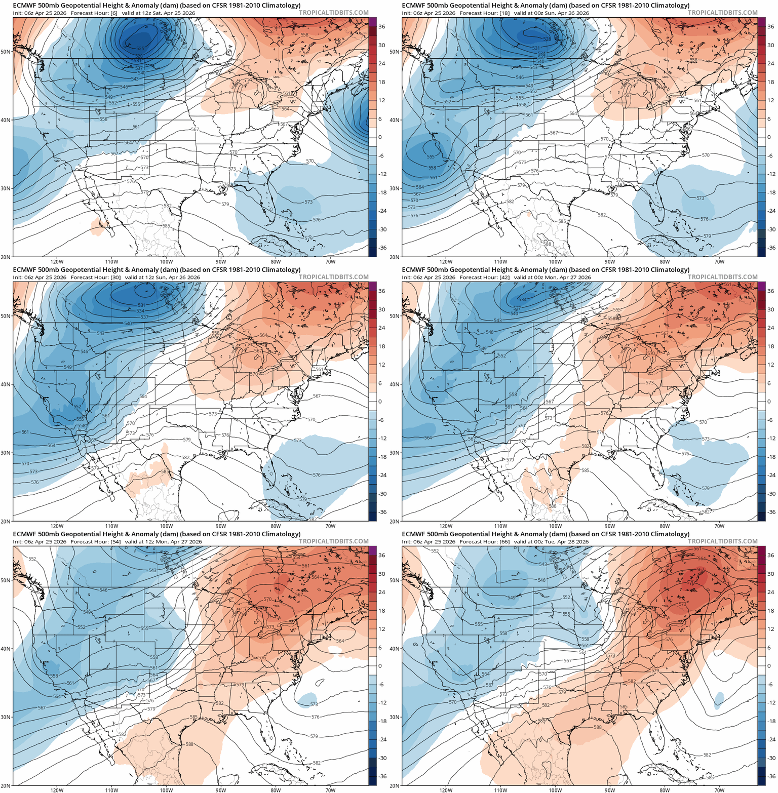
    The 500mb anomaly analysis today through late next work week (4/16-4/23) helps illustrate the progressive pattern.

    EPS 500mb anomaly from 4/16 at 1700 PDT to 4/22 at 1700 PDT.

    Today’s (4/16) cool, breezy weather associated with a departing trough in the Great Basin, gives way to a ridge of high pressure Fri – Sun (4/17-4/19) bringing mostly clear skies, moderating temperatures, and light winds for the first half of the coming weekend.

    Expect highs in the backcountry above 8000′ to climb into the low 40s on Fri and mid 40s on Sat (4/17-4/18) under sunny skies with generally light winds. Breezes out of the N and NE on Fri will become variable Sat before transitioning back to the S and SW on Sun (4/19) ahead of the next weather system.

    Lows on Fri and Sat nights will drop well below freezing, with some inversions developing both nights, keeping depressions and valleys a few degrees cooler than midslope areas. The combination of ample sun, light winds, above freezing days and cold nights will provide a great window for excellent spring corn skiing.

    Sun (4/19) increasing SW winds and clouds will signal the arrival of the next storm system which will linger across the west for most of the coming week. Models suggest a fairly deep cutoff low pressure system dropping in from the Gulf of Alaska and meandering about off the CA coast before coming ashore midweek.

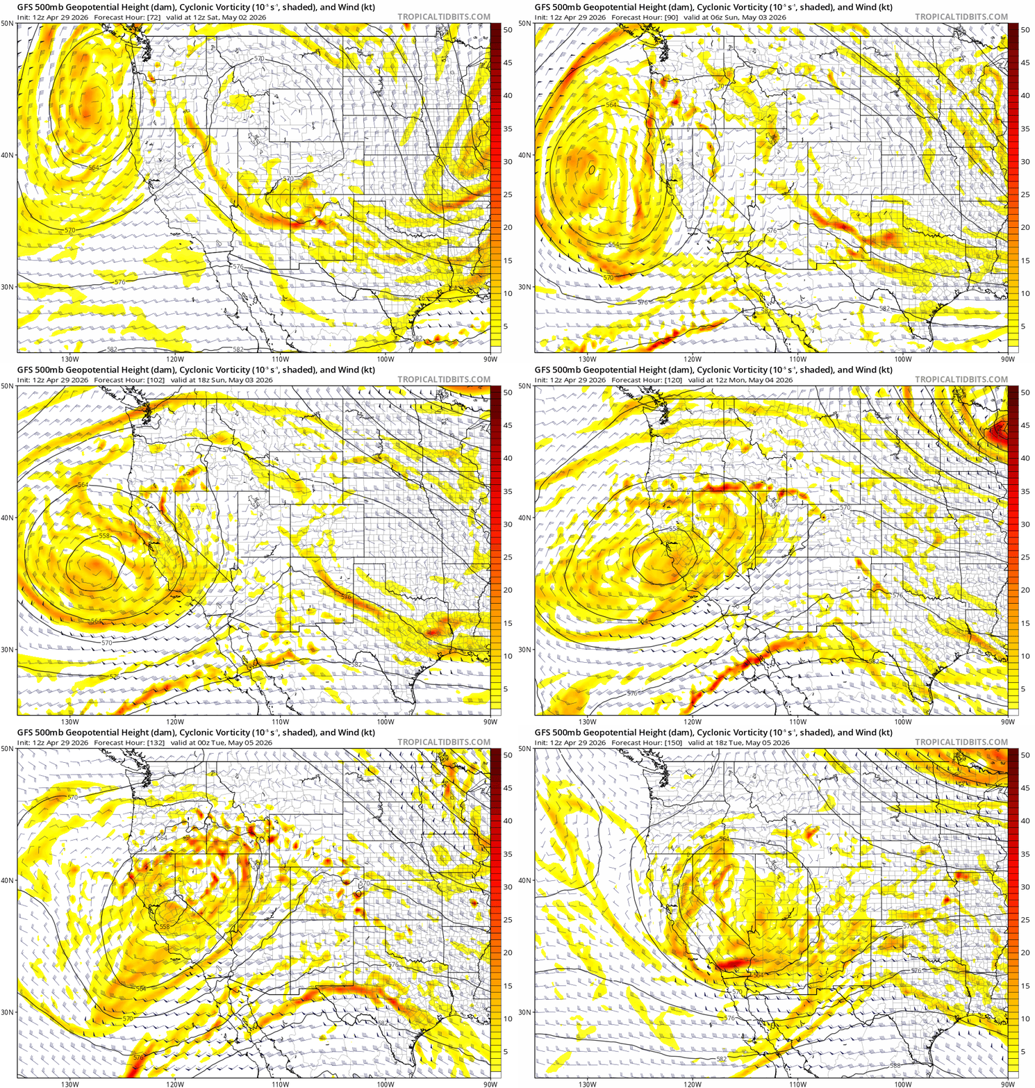
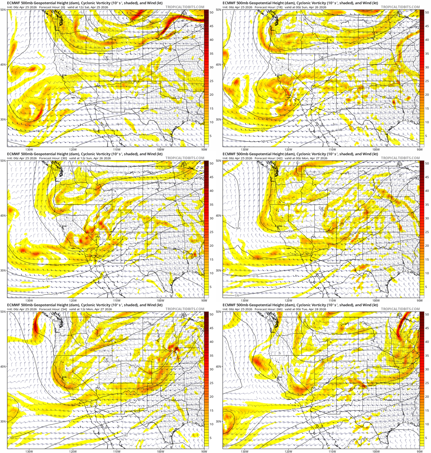
    ECMWF 500mb vorticity and winds from 4/19 at 1100 PDT to 4/22 at 1700 PDT.

    Lifting dynamics with this cutoff low look substantial. Coupled the seasonal instability common in spring, this system could also instigate afternoon convection and thunder along the Sierra.

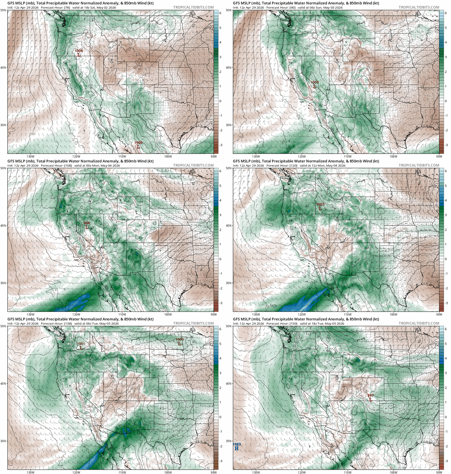
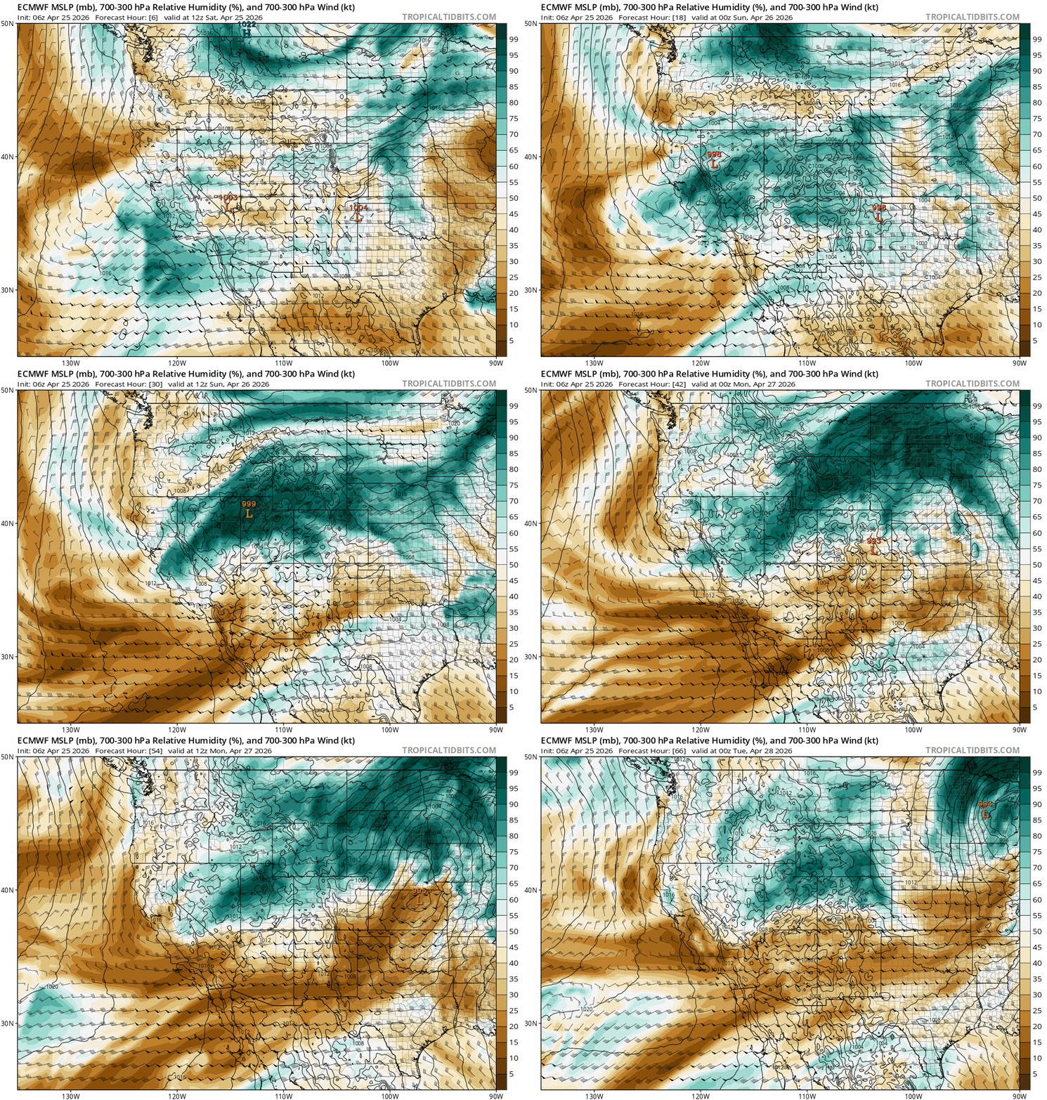
    Models also suggest the system will phase with Pacific moisture, creating good chances for rain and snow in the backcountry. Below is the ECMWF forecast total precipitable water (PWAT) anomaly analysis for the same period. (PWAT anomaly shows how much more water than climatologically normal will be in the entire atmospheric column, able to be rained or snowed out.)

    ECMWF PWAT anomaly from 1100 PDT on 4/19 – 1700 PDT on 4/22.

    Because both the dynamics and moisture look to phase, expect unsettled weather with accumulating rain and snow across the backcountry.

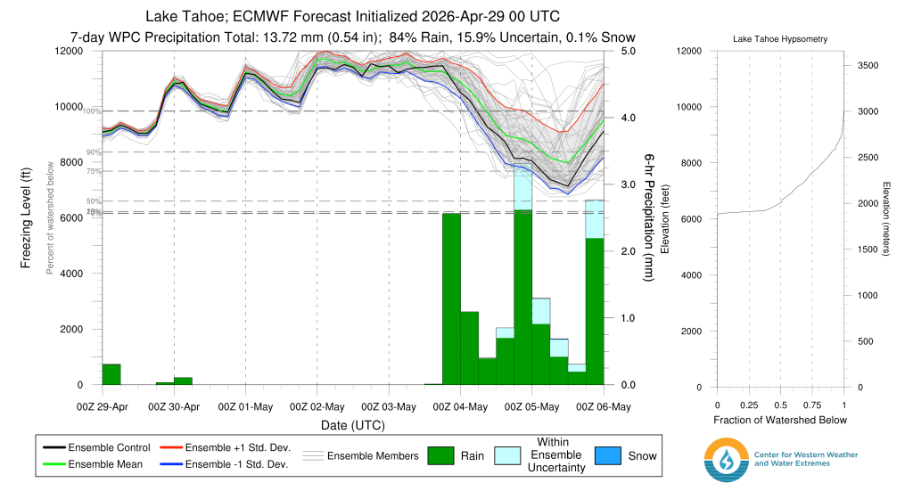
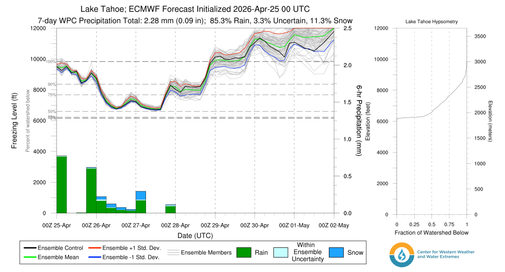
    Snow levels will likely fluctuate with the system dropping to near lake level at night starting Mon night (4/20), then rising again each afternoon with the heat of the day.

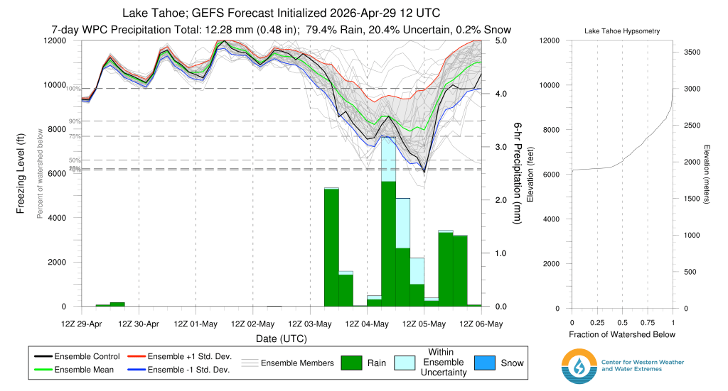
    ECMWF freezing level forecast for the Tahoe Basin watershed from 0500 PDT on 4/16 – 0500 PDT on 4/23

    Because the low is dropping in from the cool Gulf of Alaska, it will bring colder air and lower snow levels to the Sierra. However, should it stall out over the warmer than average waters off the CA coast, snow levels would edge higher as the warmth of the ocean moderates air aloft.

    This far out, there is some model disagreement, along with the lower than normal skill models tend to have in April. Expect changes to the forecast as the week draws closer. A big dump looks unlikely, but unsettled days of rain and snow showers–and even some thunderstorms–look possible.

    Until then, a brief window of cool sunny days and cold nights will bring great corn conditions across the higher terrain. Deep in the mountains, backcountry season hangs on.

    Share this:

    • Share on Reddit (Opens in new window) Reddit
    • Email a link to a friend (Opens in new window) Email
  • Curtain call for winter in the backcountry

    March 29th, 2026

    Backcountry obs.:

    Over the past week, I observed the snow in the Mt. Rose area primarily on foot, running newly uncovered trails all the way up to and just above snowline. As of Fri (3/27), usable snow doesn’t begin until around 8500′, just below Tahoe Meadows. As expected, snow surfaces are heavily textured with pocked, pre sun-cupped divots and forest debris, more reminiscent of late spring and early summer.

    The highest Tahoe trailheads above 8500′ still have snow, but patches of dry ground grow larger each day. Tree wells now expose bare ground and solar aspects are dry, even up to summits, limiting skiable terrain to N-E aspects in what will soon become summer patch skiing.

    Where snow remains, there is still fun to be had. Refreezes above 8000′ returned this week, with increased winds and cooler temps aiding radiational cooling to firm up snow surfaces overnight. Touring from 8650′ to 9300′ at dawn on 3/27, I found supportable, refrozen crusts making travel quick and at times slippy. Below 9000′ in heavily forested areas, snow surfaces hadn’t refrozen as completely, yet were still supportable, while open areas had frozen hard. With temps climbing into the mid 40s each day, mid morning snow surfaces should soften into corn or summer schmoo, making for buttery-fun last turns.

    It’s been a fun, yet short ride this season, Señor Snowpack. Thanks for your efforts, but please do better next year. You came late, doddled for a bit, then peaked with a flash, before quickly disappearing out the back door. You’re always invited, but next time, make yourself comfortable and hang out for a while.

    Weather and forecast thoughts:

    Today and tomorrow mark the end to three weeks of anomalous heat as more seasonal temperatures and showery weather return for the coming work week. Today (3/29) high temps above 7000′ will make one last return to the low-mid 60s under sunny skies, while lows tonight fall into the mid to upper 30s. Light to moderate zephyr-like winds will pick up out of the S and SW this afternoon.

    Monday (3/30), increasing cloudiness and cooling temps will kick off the week presaging the arrival of a more unsettled, showery spring pattern as the dominant ridge of high pressure responsible for weeks of warmth, finally decamps. Highs will reach the low to mid 50s on Monday under a mix of clouds and sun, eventually becoming overcast. Clouds build in Mon night and by Tues (3/31) rain and high elevation snow showers look likely, lasting into late Thurs (4/2). Lows Mon night should fall into the mid 30s above 7000′.

    As the ridge of high pressure moves off, a trough of low pressure will drop down from the Gulf of Alaska, with its parent low likely coming ashore near Columbia River late in the work week.

    EPS 500mb heights from 3/31 at 0500 PDT to 4/3 at 1700 PDT.

    While the pattern will turn cooler and showery with snow levels falling to near lake level by midweek, this system doesn’t appear to have the dynamics and moisture to put down any significant snowfall that could hold or reverse the fortunes of the backcountry.

    Upper level dynamics through the period (Tues-Fri) show weak shortwaves passing through the Sierra on Tues and Weds (3/31 and 4/1), followed by the main low coming ashore in the PacNW on Thurs (4/2). In both cases, the main lifting dynamics look weak to moderate over the Sierra, lacking the driver for any long lasting, heavy precip.

    EPS 500mb heights and vorticity from 3/30 at 1700 PDT to 1700 PDT on 4/3 showing upper level lifting dynamics.

    Available moisture for the above dynamics to interact and precipitate out doesn’t look very impressive either. While there will be enough to create generally spring-like rain and snow showers, models don’t currently depict any deep moisture feeds that align with the strongest dynamics, a recipe for more prolonged, heavy precip.

    PWAT anomalies from 1700 PDT on 3/31 through 1700 PDT on 4/3.

    Model ensembles for total precip. through Fri evening (4/3) follow the same script. Modest amounts likely fall throughout the week, renewing soil moisture and keeping lower elevation trails wet and tacky, while putting down a few inches of snow for the upper elevations.

    EPS ensemble for total precip through 1700 PDT on 4/3.

    But a few inches of snow atop dirt won’t do it. Some of the highest zones above 8000′-9000′ might see up to 6″ of new snow through Fri, which could make for a few fun, end of season powder turns for the most motivated.

    Looking into next weekend, skies clear out and temps look to rebound to above normal as another ridge of high pressure likely rebuilds in the Eastern Pacific.

    Winter’s probably gone, but the glories of trail season await!

    Share this:

    • Share on Reddit (Opens in new window) Reddit
    • Email a link to a friend (Opens in new window) Email
←Previous Page
1 2 3 4 … 52
Next Page→

Create a website or blog at WordPress.com

Loading Comments...

    • Subscribe Subscribed
      • Tahoe Backcountry Snow
      • Already have a WordPress.com account? Log in now.
      • Tahoe Backcountry Snow
      • Subscribe Subscribed
      • Sign up
      • Log in
      • Report this content
      • View site in Reader
      • Manage subscriptions
      • Collapse this bar