1515 wx. at 6350′ in Carnelian Bay: 49.3°F / 24.1°F dew point / 37% RH
Weather and forecast thoughts:
The warm and wet parade of storms from November has long since passed and in its wake, Tahoe has been cool and dry with no measurable precipitation since Fri (11/21).
The pattern responsible for the recent dry spell is locked in and will continue for at least the next 10 days. A cool down from a dry inside slider is likely tomorrow and Thurs (12/3-12/4), but apart from NE winds and colder temps barely nudging 40° on Weds, it will be uneventful.
Temps rebound quickly towards the end of the week and weekend with highs around Tahoe returning to the low 50s under sunny skies. Inversions will reign each night as lows dip to near or below freezing in valleys and depressions while the upper elevations remain above freezing in a very dry airmass. Snow season remains on hold.
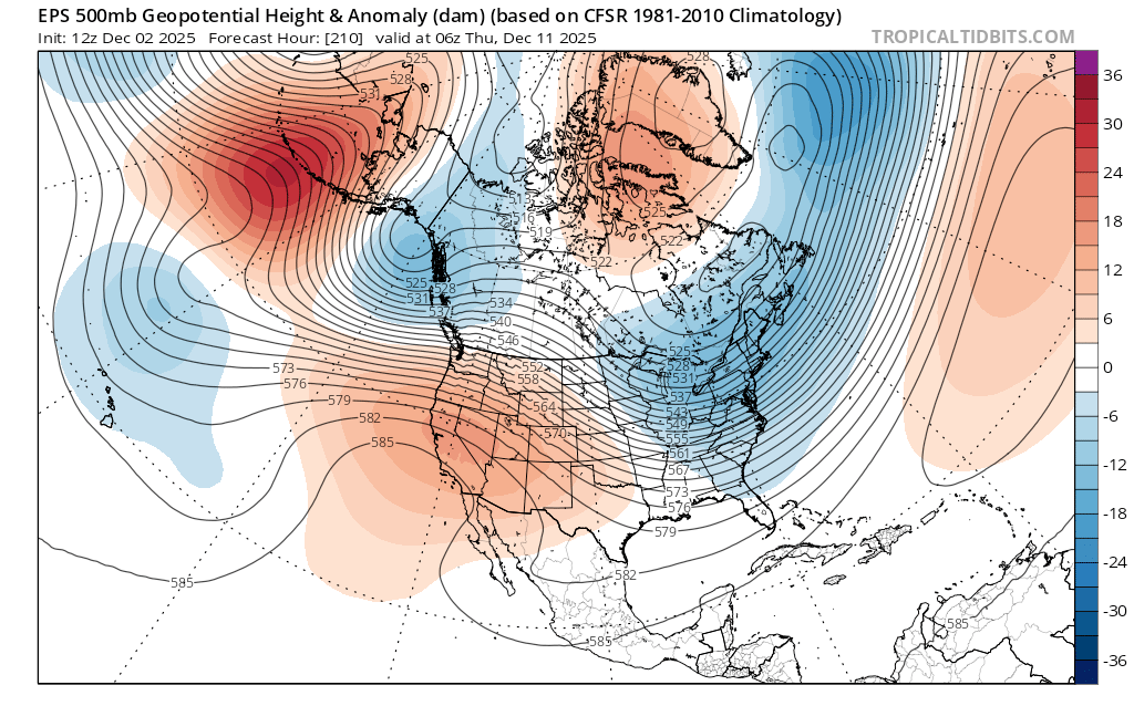
Models suggest a cut and paste forecast for next week (12/8-12/15), with ye olde ridge blocking any precip from getting anywhere near the Sierra. By midweek the ridge actually centers itself over CA:
Valid Weds, Dec 10 at 2200 PST
But as the sage George Harrison reminds us, all things must pass. There’s noise in the ensembles by mid month hinting at a return to unsettled weather.
817 wx. at 6350′ in Carnelian Bay: 36.3°F / 31.3°F dew point / 82% RH / .06″ liquid precip in past 24 hours
0515: wx. at 8650′ TH in Mt. Rose area: 24°F / dense fog / light to mod NE winds
0613 wx at 9880′: 22.9°F / 22.0°F dew point / 98% RH / NE winds between 10-20mph
Backcountry obs.:
This morning dense fog and moderate NE winds ruled the backcountry. Between 4″-8″ of new snow accumulated above 8700′ in the last 48 hours. The saturated airmass, coupled with moderate NE winds has rimed trees and added density to the new snow, making it slow and grippy on the decent. Sharks still abound and are difficult to identify amidst the highly trafficked surface and new snowfall partially filling old tracks.
The Mt. Rose backcountry has gotten quite a bit of action over the past week, despite an early season snowpack; it’s really the only place in North Lake with usable snow. The recent warm, low end storms have left anywhere from 6″ to 2’+ of base depending on elevation and aspect, with 9000′ serving as a solid line of demarcation for usable snow.
Weather and forecast thoughts:
Today (11/21) begins a stretch of clearing and calm late fall weather through Thanksgiving (11/28). Today skies will begin clearing out with temps remaining fairly chilly: below freezing above 8000′ and flirting with 40 at lake level. The weekend will start out cool, but temps warm a bit each day into the beginning of next week under mainly sunny skies. Expect highs in the 30s to low 40s around 8000′ with lows well below freezing each night. A drier airmass and good radiational cooling should help preserve the new snowpack starting this weekend through next week.
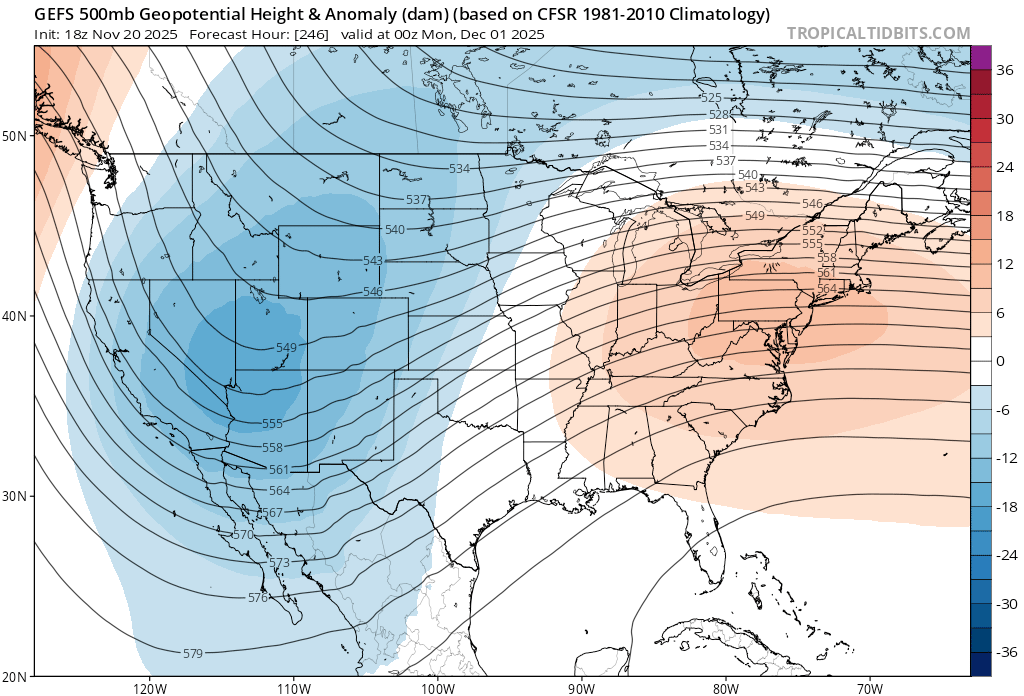
Looking out past Thanksgiving, models do signal the possibility of a colder storm developing the weekend after. It’s a long way off, but model ensembles seem to be latching onto this possibility.
GEFS ensemble for Sunday, 11/30 at 4pm PST.
One item to note with this map is the position of the trough over the Great Basin. Setups like this often bring cold storms, but with less abundant precip. The cold air dropping down over land isn’t able to pick up abundant Pacific moisture, so storms tend to have less available juice to work with, but also trend colder. Should this scenario pan out, expect low snow levels (5000′ or lower) and cold, low density snow.
Looking at the long range, there are some indications that the pattern may get stuck around the beginning of December. The Arctic Oscillation (AO) may weaken considerably going negative, thus allowing polar air to spill southward to the mid-latitudes. This far out there’s much uncertainty about how a negative AO might play out, but it typically leads to a continental dipole with one side of North America in the deep freeze under a deep trough, while the other side of the continent sits under an amplified ridge of high pressure hosting mild, storm free weather. More often than not, the West ends up under the ridge.
Right now models are mixed. A strong negative AO this time of year is uncommon. The atmosphere is also still transitioning from summer to winter. These variables help support the fact that variability is at a max, lending to mixed model solutions.
As always, time will ultimately tell. If the trough axis develops too far to the east over the Rockies, then moves out over the eastern 2/3 of N. America, expect dry weather and mild temps. But if it develops 500 miles to the west, that could put Tahoe in line for cold weather and more storms.
For now, it’s time to enjoy snow up high, good trails down low, and awkward conversation over holiday dinners.
1602 wx. at 6350′ in Carnelian Bay: 50.2°F / 45.0°F dew point / 82% RH / 11/13-11/14 precip total: 1.75″ rain
Backcountry conditions:
A quick morning exploration of the Mt. Rose area this morning revealed the nascent snowpack had crept a bit lower since late last week, despite the warm storm on Thurs and Fri (11/13-14). Trails from 7000′ to 8500′ are spongy and saturated, while snow begins mixing in on the ground above 8500′. Consistent wet snow coverage began around 8800′ and increased in depth with elevation. By the time I bailed at 9700′ on Relay Peak around 1100, there was a heavy, wet snowpack 8-10″ deep, saturated all the way to the interface with the ground. Temps ranged from the mid 40s around 7400′ to the mid 30s above 9500′.
Weather and forecast thoughts:
Another round of high elevation snow and steady rains will begin affecting the area Sat PM lasting through Sun PM. Snow levels will initially start high (between 9500′-10,000′) this evening, before crashing down to near 7000′ by Sun morning (11/16). Snow and rain will continue most of Sun with snow levels bobbing in between 6500′-7000′ throughout the day. Accumulating snows will be mostly confined to zones about 8000′ where 6-12″ of heavy, wet snow could fall though Sun evening.
Monday (11/17) another storm enters the picture that models suggest will be colder than the 11/13-14 and 11/16 rounds of rain/snow. Like the most recent storm, Monday’s storm will be a wobbly cutoff low, notoriously tricky to forecast. As of late Sat, the thinking is that this storm will bring mainly snow to the Sierra above 6000′-6500′ during the day on Mon. Additional accumulations of up to a foot could fall in the higher zones of the Mt. Rose area and especially along the Crest above 8000′.
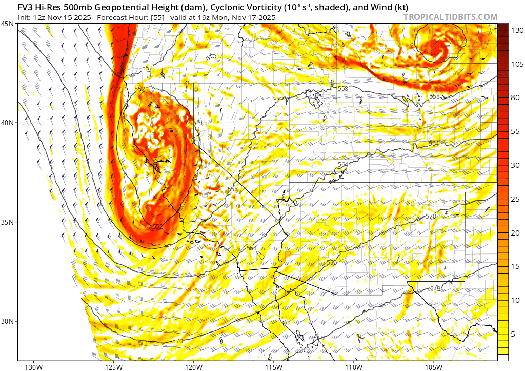
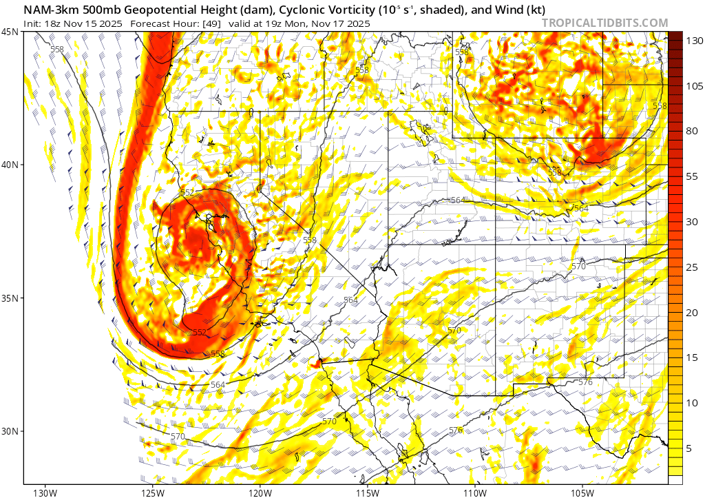
Forecast confidence in the track, snow totals, and snow levels is still moderate at best with the Monday storm due to varying model projections. The high res FV3 model shows a slightly wetter storm dropping down from British Columbia into Central CA (a colder solution), while the high res 3km NAM keeps the storm a bit further west, dropping further south down along the CA Coast. This setup could bring higher snow levels and less precip east of the Crest.
The below examples showing atmospheric dynamics half way up in the atmosphere show the different storm track forecasts.
FV-3 vorticity analysis (atmospheric spin/dynamics)and wind barbs halfway up in the atmosphere (500mb) on Mon (11/17) at 11am PST. 3km NAM vorticity analysis (atmospheric spin/dynamics) and wind barbs halfway up in the atmosphere (500mb) on Mon (11/17) at 11am PST.
Believe it or not, these subtle differences in storm track can make a huge difference in how much precip and what type actually falls.
For all the lingering uncertainty with this next round, what does feel quite certain is that today’s trail run up to 9700′ in the Mt. Rose area will be my last of the season. It’s time to trade the shoes for skis.