Skip to content

Tahoe Backcountry Snow

  • Winter 25-26 Forecasting JournalSeasonal forecasting narrative and journal.
  • Current Wx. at 7650′Current weather station info at 6350′ in Carnelian Bay.
  • About
  • Glossary of Terms
  • Archive
  • “Breakdown, go head and give it to me…”

    February 3rd, 2026

    Backcountry Obs:

    After receiving only 1-3″ of snow on 1/28, the only snow since 1/8, backcountry snow surfaces are in the exact condition one might expect in a snow drought situation. Melt freeze snow and mostly supportable, dense, old crusts cover all but the most sheltered N and NE aspects. Cold, protected zones host areas of wind buffed vintage powder, mostly remnants of the 1/28 disturbance sitting atop cold and decaying windboard and crust. Solar aspects have decent mid-winter corn snow, ripe for carving during the midday hours.

    A predawn tour of the Mt. Rose backcountry between 8650′-9820 on 2/2 revealed a still skiable, yet athletic and chattery snow pack hammered by weeks of use with nonexistent natural improvement. I was delighted to find that upper elevation coverage remains excellent thanks to the feet of dense base deposited in the last weeks of 2025. Even after weeks of warm, dry weather, low sun angles prevented the catastrophic melt out one might expect given the recent weather. Below 8000′ where the holiday storms dropped more rain than snow, melt-out concerns are very real, especially on solar aspects.

    While the season has felt grim for weeks, I believe it’ll be remembered as the year with two springs: mid-winter and actual, interrupted with stormy intervals providing just enough snow to create a backcountry season. After weeks of dread, model guidance looks to finally hint at a pattern change and return to winter in weeks ahead.

    Weather and forecast thoughts:

    Mid-winter spring holds strong for the remainder of this work week as high pressure rebuilds over the area Tues-Thurs (2/3-2/6), before beginning to erode away later in the week and into the coming weekend (2/7-2/9). In the Sierra, this translates to more warm, mostly sunny days and clear cold nights. Above 7000′, high temps will easily hit the mid 40s through Sat (2/7). Inversions will remain persistent with valleys and depressions quickly cooling each night into the 20s, while ridge tops and summits stay above freezing, but locked in a bone dry atmosphere. For example, as of this writing at 0515 on 2/3 it’s 41°F on the 9650′ summit of Slide Mountain, but with a -11°F dew point! Despite the warmth, such dry air keeps snow surfaces frozen via evaporational cooling.

    Models suggest some high cloud cover returning by Thurs (2/5), lingering about into the weekend under a “dirty ridge” scenario as the recent dry pattern slowly begins breaking down into something resembling a stormier pattern for the Sierra.

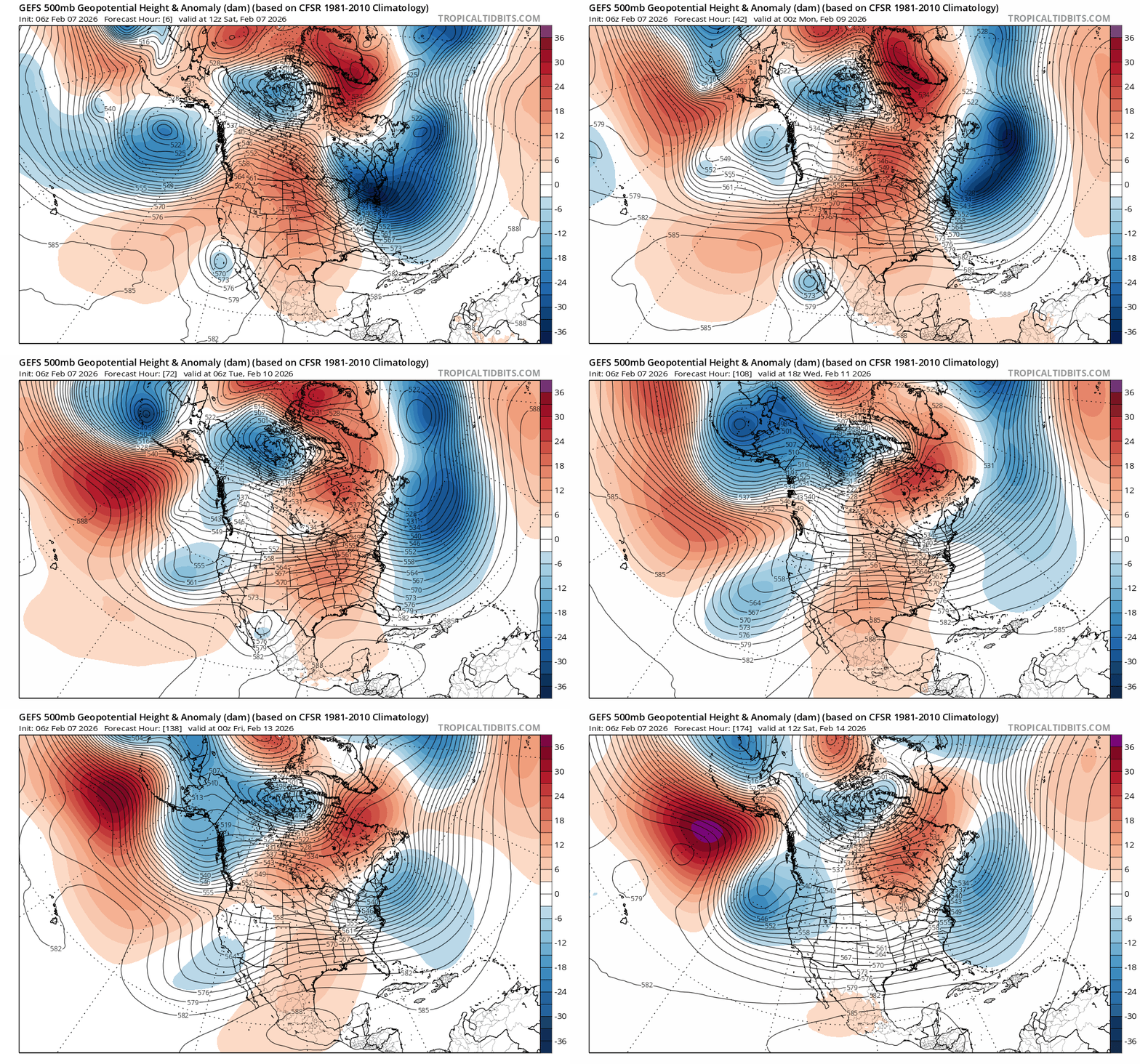
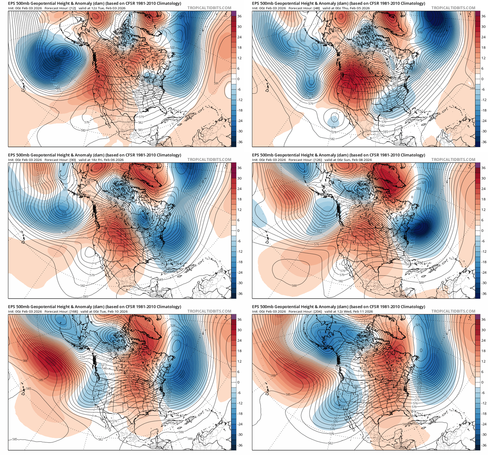
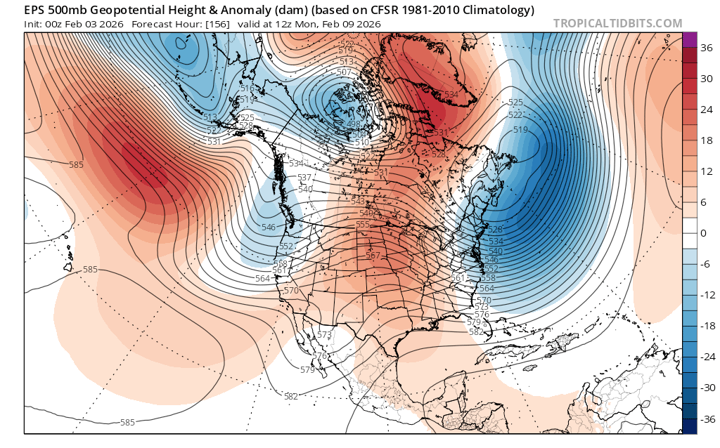
    Over the past few days, model ensembles have fallen into decent agreement showing the warm, dry pattern transitioning towards a more sustained, stormy pattern in the coming weeks. A big picture look at 500mb heights helps tell the story.

    EPS 500mb height anomalies from 2/3 at 0400 PST to 2/11 at 0400 PST.

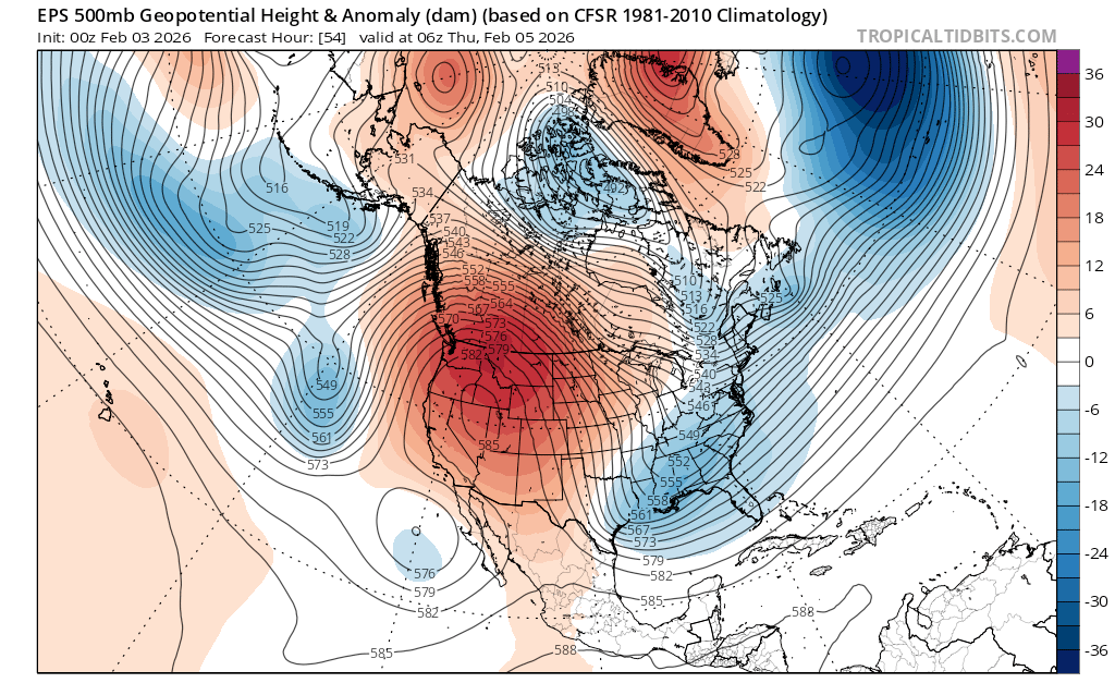
    The ridge of high pressure (oranges and reds) hangs on across the west early in the week, but by Thurs (2/5), its axis begins leaning back towards the west. (Notice the bend in the black thickness lines.) This is known as a negative tilt, often indicative of weakening. Underneath the ridge, a weak cutoff low begins to form as noted by the closed 576 line off Baja, Mexico.

    And concurrently, another trough of low pressure develops over the Pacific as noted by the dip in thickness lines and blue shading about 800-1000 miles due west of San Francisco Bay. While these features will not bring any precip. to the Sierra, they do suggest a breakdown of the persistent ridge responsible for weeks of warm, dry weather.

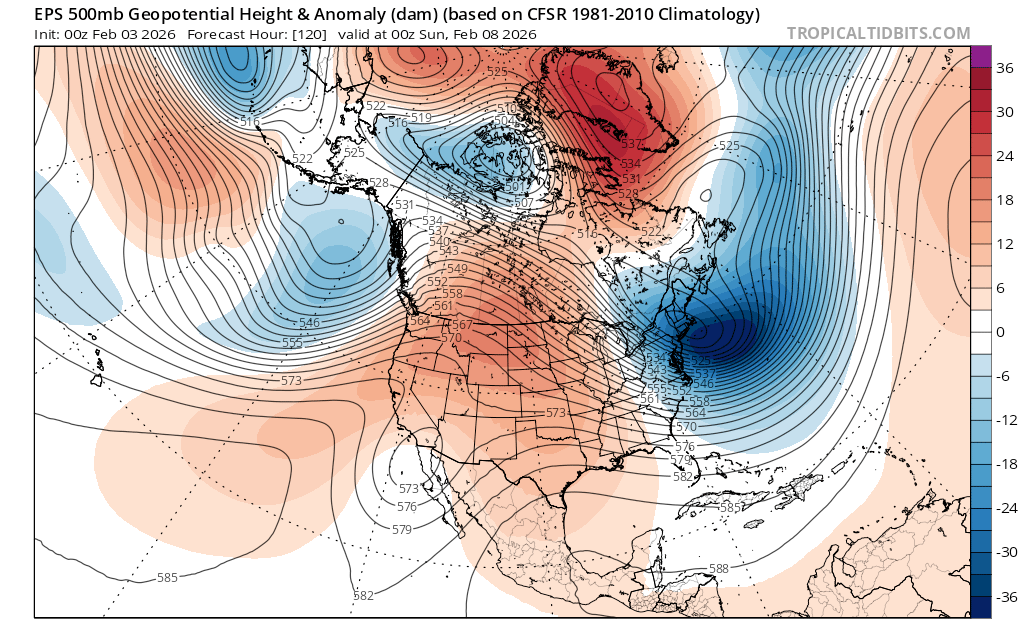
    Right on the heels of these disturbances, a modest shortwave ridge rebuilds and swings through northern CA on Sunday.

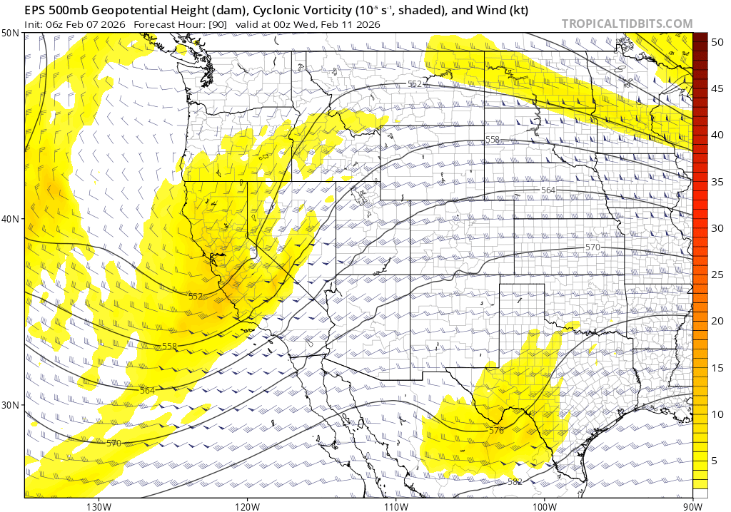
    But right on its heels, a trough of low pressure drops in on Monday, signaling the next chance for snow in the Sierra.

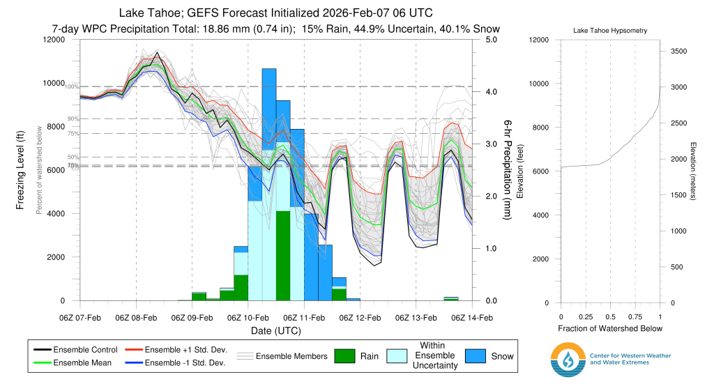
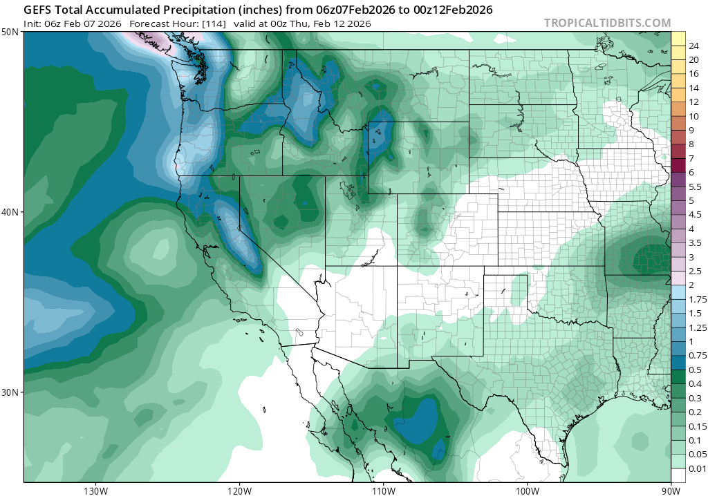
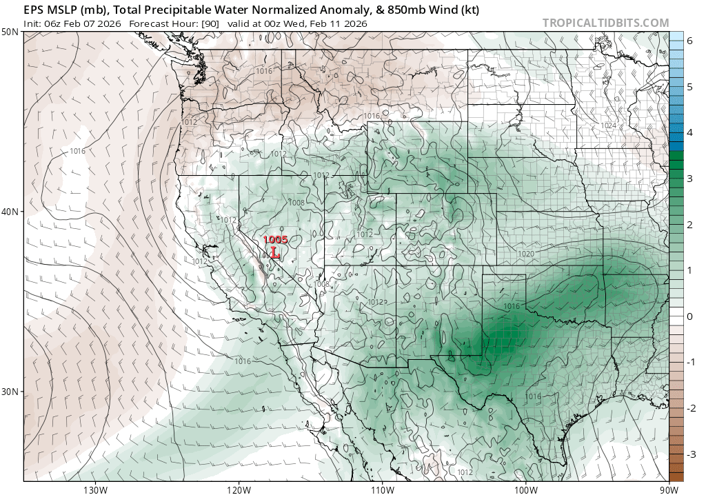
    Precip. models going into the beginning of next week largely agree on the return of rain and snowfall across northern CA and the Tahoe Sierra. And storminess could continue through the coming week.

    While precip. amounts don’t appear particularly noteworthy, considering the state of the winter for the past month, they could provide a meaningful refresh to the snow pack and backcountry skier outlook for the remainder of the season.

    Share this:

    • Share on Reddit (Opens in new window) Reddit
    • Email a link to a friend (Opens in new window) Email
  • Slip slidin’ away…

    January 25th, 2026

    Backcountry obs.:

    Heading out Tuesday (1/20) on tour in the Mt. Rose area revealed a largely thrashed snow pack, severely degrading morale. Weeks of high user traffic, coupled with melt-freeze crusts on all but the shadiest N and NE aspects, have created firm, chattery, and sometimes breakable surface conditions not good for much more than honing survival ski skills. Due southerly aspects do host supportable melt-freeze surfaces, softening on sunny, warmer days providing buttery corn to relieve those weary of the snow drought blues.

    Since midweek high clouds and increased humidity in the middle elevations likely baked any remaining soft surface snow on N and NE aspects, which has since refrozen into breakable crusts now that cold air has returned to the Tahoe Sierra. Lower humidity on the snow pack at the highest elevations could have potentially preserved a few sheltered pockets of cold snow on N and NE aspects, but whatever does exist is likely small and worth no more than a few turns. Good luck finding the pot o’ gold!

    Weather and forecast thoughts:

    The last measurable snowfall in Tahoe was on Jan 8. Looking at the coming week it’s increasingly likely that January will close out without additional measurable precip. Expect the cool NE flow over the area this weekend to moderate early in the work week (1/26-1/27) under mostly sunny skies as a ridge of high pressure restrengthens overhead. Late Tues and into Weds (1/27-1/28), a system tries to nudge into the area, but looks to be largely blocked by the resident high. The result may be an uptick in winds, especially over the higher terrain, cloud cover and potentially a few flurries, but without meaningful accumulations. Behind the shortwave, model guidance shows a ridge of high pressure rebuilding over CA holding into the coming weekend (1/31-2/1).

    Expect high temps across the backcountry this week to be in the upper 20s to mid 30s on Sunday and Monday, climbing into the upper 30s to low 40s around midweek. Inversions are likely at the beginning of the week, so ridges and summits could be 10-15°F warmer than surrounding valleys in the stable air mass. Late week backcountry temps look to moderate well into the 40s each day as another ridge takes hold. Expect inversions to return, as well.

    Here’s a snapshot of the big picture pattern for the week:

    EPS 500mb height anomalies through 1/30 @ 2200 PST

    Diving a bit deeper into the midweek disturbance, models disagree on how much miniscule moisture makes it to the Sierra, further degrading confidence in the forecast. The Euro ensemble brings more moisture in while the GEFS retains a drier solution.

    EPS 24 hour total accuulated precip for midweek disturbance.
    GEFS 24 hour total accumulated precip for midweek disturbance.

    Where there is agreement is that any disturbance that does arrive will be little more than that: just a nudge to the airmass bringing some wind, clouds and maybe a flurry or two. The dynamics (mid level vorticity) to wring out moisture are very weak.

    EPS 500mb vorticity (ie spin or dynamic forcing) at 0400 PST on 1/28.

    And there just won’t be much moisture to wring out.

    EPS PWAT (total precipitable water above climatological norm) for 0400 PST on 1/28.

    So on the midweek storm, an amazing surprise of good fortune might be an inch or two in the backcountry, but such an outcome looks highly unlikely.

    After the midweek disturbance, another ridge of high pressure builds in setting the stage for more sunny, dry weather.

    Looking out into February, models have recently been quite inconsistent between runs. The strong ridge from earlier this month doesn’t look to return with the same strength as in January, but a trend towards high pressure and above average temps looks more likely than not, at least for the first week of the month. There are some hints at a pattern of undercutting lows that could bring precip to the Sierra. But strong signals of a significant pattern change yielding impactful storms just haven’t appeared.

    Meanwhile, the days of winter keep slipping away.

    Share this:

    • Share on Reddit (Opens in new window) Reddit
    • Email a link to a friend (Opens in new window) Email
  • Rinse and repeat, but without the rinse

    January 19th, 2026

    Backcountry obs.:

    Touring deep on the West Shore this weekend, I found a snowpack closely reflecting the Juneuary weather of the past month.

    Below treeline, N-E aspects host a combo of cold, soft snow interspersed with delicate breakable crust: delightful to defensive skiing within a few feet. Shaded valleys and creek depressions have remained well below freezing each night, pooling cold, moist air, perfect for growing delicate surface hoar that in some areas has accumulated multiple inches deep. Ski turns through this recycled pow shatter at once like fine crystal on marble, tinkling as they scatter across the snow surface. It’s a remarkable sound and feeling.

    Venturing out into the sun from the cold backcountry hideaways, the snow wears heavy weeks of sun and heat. Breakable crusts atop heated mush are the main story in the trees, while open, due south facing areas hold supportable melt freeze crusts that under clear skies and light winds, have softened into smooth butter each afternoon. Buttery turns aren’t bad.

    Up at the highest elevations, despite the warm temps, extremely dry air has kept snow surfaces mostly frozen. Ridges and summits host all forms of sculpted sastrugi, edgeable wind buff and occasional soft, textured, wind deposited snow. Carrying a whippet or axe is a wise idea in high consequence terrain where firm surfaces abound.

    It’s a variable thrift shop of conditions out there. Add in the heavy holiday traffic and you’ll find popular zones thrashed with tracks, ruts, dinosaur tracks (snowshoes), and even some lamely poached snowmobile tracks.

    As they dry days stack up and extend into the future, the calculus of skiing an ever degrading backcountry snow pack versus doing anything else fun becomes harder to pencil out.

    Weather and forecast thoughts:

    Looking ahead at the coming week (1/19-1/25) dry and warm weather will continue to exacerbate the growing snow drought in the Tahoe Sierra. No precip. throughout the entire week seems nearly guaranteed. Temperatures look to remain steady with only a few modest variations: edging up a few degrees by midweek, then cooling by a few degrees by the weekend.

    Highs this week will generally wobble between the low to mid 40s through the work week and into next weekend above 7000′, under a very dry air mass. Low temps already a bit cooler than last weekend will drop into the low to mid 30s along higher terrain, with temps into the 10s and 20s in valleys and depressions each morning. Expect a bumper crop of surface hoar throughout the week. Shaded aspects should continue to hold onto vintage, dirty powder with the dry airmass.

    Yee ole’ persistent dome of high pressure continues to defend the Sierra from any hint of a storm system. Around midweek ensembles do show a cut off low developing off SoCal and undercutting the ridge, but it will then move off into the desert Southwest without much trace for the Central Sierra. A few high clouds and breezes might be the only evidence of its passing.

    GEFS ensemble of 500mb thickness from midday PST on 1/19 through 1/26 at 0400 PST.

    As noted above, behind the low another ridge redevelops over CA, reinforcing warm, dry conditions going into next week (1/26-2/1).

    An interesting, although grim, note about this pattern is its resilience. Looking at a model of the amount of spin half way up in the atmosphere (aka 500mb vorticity), it’s evident how the blocking ridge dissipates and largely deflects any storms that try to penetrate it. The below GFS model spans the North Pacific and goes out until 2/4. Storms are denoted by brighter colors showing areas of greater spin (vorticity). Note the path of disturbances as they approach the CA Coast.

    GFS model showing 500mb vorticity 1/19-2/4.

    A model going out this far will almost certainly play out differently than depicted above. However, it’s instructive in showing how persistent and entrenched the current pattern is and its ability to stave off perturbations.

    Change will come, but it’s not looking likely until at least the beginning of February.

    Share this:

    • Share on Reddit (Opens in new window) Reddit
    • Email a link to a friend (Opens in new window) Email
←Previous Page
1 … 5 6 7 8 9 … 52
Next Page→

Create a website or blog at WordPress.com

Loading Comments...

    • Subscribe Subscribed
      • Tahoe Backcountry Snow
      • Already have a WordPress.com account? Log in now.
      • Tahoe Backcountry Snow
      • Subscribe Subscribed
      • Sign up
      • Log in
      • Report this content
      • View site in Reader
      • Manage subscriptions
      • Collapse this bar