Skip to content

Tahoe Backcountry Snow

  • Summer 2026 Forecasting JournalSeasonal forecasting narrative and journal.
  • Current Wx. at 7650′Current weather station info at 6350′ in Carnelian Bay.
  • About
  • Glossary of Terms
  • Archive
  • Early fall storms and seasonal musings

    October 29th, 2024

    0600 temp. at 6350’ in Carnelian Bay: 30.4 deg. with 90% RH

    New snow: Trace – .5”

    Recent Weather Obs.:

    After a warm, dry summer – with relatively little smoke – Tahoe weather turned more active over the past week. Today marks the second, barely measurable morning snowfall just above lake level! The shift in the weather has turned my daydreams away from running through crispy golden meadows to resplendent mornings spent floating down mountains stacked in soft, fluffy powder. It’s time to start thinking about snow!

    Weather watching over the past few days has really become exciting with periods of high winds, showers, and great lenticular cloud shows, especially at dawn and dusk. Windy and unsettled conditions arrived Sunday, even dropping measurable snow on the highest peaks, especially on the SW corner of the Basin. A second round of cold and unsettled weather fired up snow showers late yesterday (10/28) dropping 1/2″ of snow on Carnelian Bay and more on the surrounding peaks.

    Early this morning, a northerly flow coupled with an unstable airmass over the warm lake waters set up a pronounced band of lake-effect snow right over the West Shore!
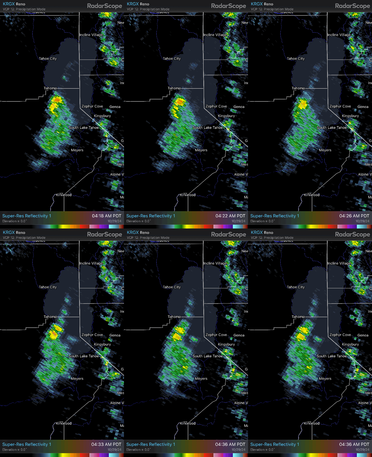
    Radar imagery of lake effect snow on 10/29/24.

    I expect that Desolation and the Jakes – Rubicon skyline received a few inches from this stationary band of lake-effect snow. Exciting stuff!

    Forecast thoughts:

    The rest of the week looks to remain unsettled with another trough of low pressure dropping down the Pacific coast from the Gulf of Alaska. This will bring a cool, northerly flow today, before another round of increased winds and chances for rain and snow showers return overnight Weds into Thurs AM, possibly lasting through the middle of the coming weekend. Models diverge on whether the weekend system will skirt our area with more cold air and increased rain/snow chances, or hit us more directly with a burst of precip. as the system drops down the length of interior CA. Halloween night looks cold and wet, possibly snowy.

    Around the lake, expect cool highs in the low to mid 40s today through Weds, before cooling off to the lower 40s Thurs through the weekend. Temps in the mountains will cool considerably with elevation, so expect highs in the 30s to below freezing for much of the period. Higher elevations will receive mainly snow coming in as a dusting to a few inches at a time.

    Beyond the weekend, the weather looks to warm gradually under a calmer, sunny fall regime with modest high pressure building back over the Sierra.

    Early season snowpack tips:

    The snow that fell Sunday (10/27) on the mountains fell on bare ground throughout the Tahoe backcountry. As more snow falls this week, it’ll be important to take stock of how much snow accumulates, and where it ends up melting vs. lingering after this cycle. The sun angle is growing weaker by the day and high elevation shady aspects and protected terrain features might not melt out til spring. Should this week’s snow last until the first respectable dump of the season, this could set the stage for basal faceting and instabilities in the snowpack.

    So take note and take pictures of the mountains while you’re out. Notice where the early season snow remains continuous. These spots will be the prime areas of concern for early season instabilities once later storms arrive with more appreciable snow.

    24-25 seasonal thoughts:

    And about those bigger storms later this season… Do I have any predictions for the 24-25 season? In short, no.

    Long term models show the Tahoe Sierra in a toss-up scenario for both precipitation and temperatures in the Dec-Apr time frame. Any strong signal one way or another hasn’t shown up. The much-advertised forecast of a strong La Niña from last spring has been lackluster to date, and could even fall into a “la nada” scenario. This where tropical E. Pacific water temps don’t even reach the threshold to be cold enough to qualify for a La Niña.

    ENSO (El Niño / La Niña) can be a big factor in Sierra winters, but it is one of several impactful atmospheric and climatic components that determines how much snow the Sierra receives. The atmosphere is incredibly dynamic and our understanding of what drives major weather patterns continues to evolve and change as we try to grasp the effects of continued warming on the atmosphere and oceans. We have so many new tools at our disposal for understanding, modeling, and predicting the weather, especially in the short term. Yet as we continue to learn, the steady warming of the earth’s atmosphere creates impacts and inputs into the global system that are not yet fully understood, much less predictable at seasonal levels.

    So at this point, the 24-25 season looks like a toss up. Enjoy whatever comes.

    Share this:

    • Share on Reddit (Opens in new window) Reddit
    • Email a link to a friend (Opens in new window) Email
  • First snow!

    August 25th, 2024

    0600 temp. at 8920’ Mt. Rose TH: 33 deg. Trace new snow.

    Backcountry obs.:

    The first measurable snow of the late summer arrived to the Sierra yesterday afternoon/evening (8/24). A deep, early season low from the NE Pacific crossed the Sierra Fri.-Sat. bringing cool, moist air and plenty of instability to drop temps, fire some thunderstorms and coat the high elevation Tahoe peaks with the first dusting of the season.

    Running the Mt. Rose trail to the summit ridge, I encountered between a trace to ~3”. Above tree line small drifts of up to 6” with light surface riming coated the ground. Finally some precip. to tamp down the late summer dust! Wildflowers and sage are amazingly fragrant today!

    Today’s snow will likely melt off by afternoon as warm temps and high pressure return to the area for the coming week. The end of summer is fast approaching!

    Share this:

    • Share on Reddit (Opens in new window) Reddit
    • Email a link to a friend (Opens in new window) Email
  • Some thoughts on spring

    April 25th, 2024

    0430 temp. at 6350′ in Carnelian Bay: 31.8 deg & 91% RH

    0520 temp. at 8650′ Tamarack TH: 26 deg.

    Recent backcountry obs.: Tamarack Peak / June Lake

    Spring is here. While the weather continues to be dynamic, the snowpack in the backcountry has settled into the predictable rhythm of melt/freeze with some days not freezing at all.

    Recent obs. from the Tamarack zone on 4/22 and 4/25 showed a marginal to solid refreezes on 4/22 and 4/25 respectively, likely softening by mid morning. The area is heavily tracked out and sun cups are beginning to pock the surface of the most sun-exposed and open areas.

    This past weekend on 4/20, conditions in the June Lake area were similar with lower elevations marginally refreezing at night, whereas the alpine received more solid refreezes on supportable transitional snow. Descending from around 11,000′ at 9am, upper elevation turns were still firm and fast, while below 9000′ snow had already turned to heavy mank and non-supportable crusts: combat skiing.

    Across Tahoe and the Eastern Sierra, temps have not yet fallen into a prolonged period of clear cold nights and warm sunny days that create widespread, quality corn snow. Melt/freeze cycles have happened, but they’ve been short lived and followed by warm periods without refreezes, that have initiated widespread wet avalanche cycles. On the opposite end, this season has also seen a few strings of melt/freeze weather followed by weak winter-like storms that brought a return of snow and unsettled weather with cold temps. It’s been a mixed bag of ying and yang, not quite hitting the ideal middle ground that produces the best spring skiing.

    Spring weather thoughts:

    Over the past few weeks, a noticeable shift in the storm track and temps has really signaled the seasonal change and arrival of spring. Big, snow producing storms are all but over. Storms from here out tend to not have the same punch and dynamics as the winter jet stream weakens and lifts northward. Systems that do arrive will bring lighter amounts of rain and snow, often in showery and convective form. Periods of colder temps, breezy conditions, and afternoon showers and storms may pass through the region from time to time before eventually fading out into the dry, placid warmth of summer.

    With the seasonal weather shift, the desire to be on the snow has begun its rapid wane. Daydreams of running fragrant trails lined with wildflowers and climbing high alpine granite in the summer sun have replaced the urge to venture out in the predawn cold to devour fluffy powder laps. It’s been a great season monitoring the snow and weather and I look forward to starting this back up in the fall. Until then, enjoy the sun and warmth.

    Share this:

    • Share on Reddit (Opens in new window) Reddit
    • Email a link to a friend (Opens in new window) Email
←Previous Page
1 … 28 29 30 31 32 … 53
Next Page→

Create a website or blog at WordPress.com

Loading Comments...
  • Subscribe Subscribed
    • Tahoe Backcountry Snow
    • Already have a WordPress.com account? Log in now.
    • Tahoe Backcountry Snow
    • Subscribe Subscribed
    • Sign up
    • Log in
    • Report this content
    • View site in Reader
    • Manage subscriptions
    • Collapse this bar