Skip to content

Tahoe Backcountry Snow

  • Summer 2026 Forecasting JournalSeasonal forecasting narrative and journal.
  • Current Wx. at 7650′Current weather station info at 6350′ in Carnelian Bay.
  • About
  • Glossary of Terms
  • Archive
  • Robust AR inbound

    November 19th, 2024

    0515 temp. at 6350′ in Carnelian Bay: 19.9 deg. w/ 84% RH

    Backcountry Obs.:

    I took a quick dawn patrol tour in the Tahoe Meadows – Relay Peak area on Sun., 11/17 between 8800-9200′ and noted around 2-6″ of snow cover. Snow was cold, but turning warm and gloppy as temps climbed above freezing, even in the predawn hours. Occasional spritzes of rain even showered down as I skinned through dense fog and moderate SW winds.

    A weak, yet cold, storm passed through on Sun night into Mon (11/18) dropping a trace of snow at lake level and 1-2″ above 7k. An attendant cold front left midwinter temps in its wake.

    Forecast thoughts:

    Late last week, most models indicated a dry, calm pattern for this week. But oh have the tables turned!

    Very wet and unsettled weather looks to arrive late tonight (11/19) and last until the weekend–and maybe beyond!–as an AR takes aim on NorCal, bringing multiple waves of heavy rain and snow to Tahoe. Models are in good agreement that the flow of moisture will set up over NorCal, mainly from Tahoe north to southern Oregon, stall there through the remainder of the work week, then drift south.

    The cuprit? A deep, rapidly strengthening low off the PacNW coast that will steer an intense upper level jet right over NorCal and southern Oregon.
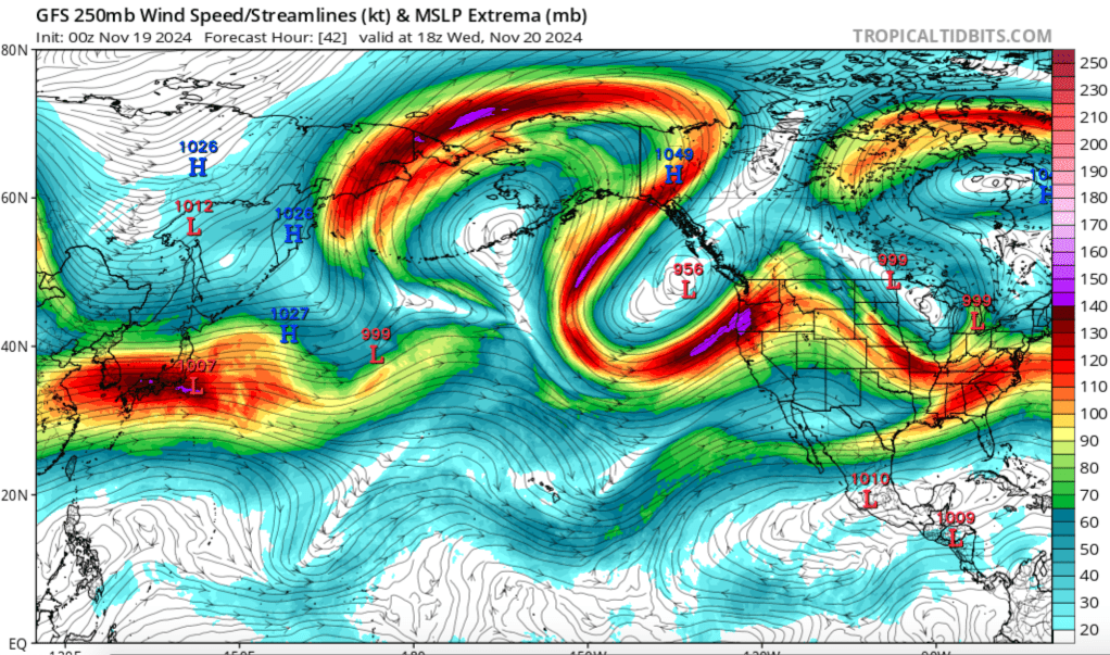
    Snow levels will start low tonight in the antecedent cold airmass left in the wake of the Sun-Mon system, then rise with the arrival of a subtropical moisture flow off the Pacific. Light accumulations could fall around the lake tonight, before turning to rain until the weekend as snow levels rise to 8500′-9000′ by Wednesday through the end of the work week. As the AR begins to push south, so too will colder air, bringing snow levels back down into the backcountry for the weekend.

    While this storm will bring mainly rain to Tahoe, the mountains could receive a foot or more of dense, heavy, Sierra cement before everything wraps up late next weekend or early next week. And while snow is always preferable to rain, the high snow levels and heavy rain may melt any existing snow below 9000′ and/or saturate whatever remains before the changeover back to snow.

    For the backcountry, this could end up being a big positive as it would destroy any weak, faceted old snow that may be lingering in the coldest nooks and crannies, replacing it with a solid base of dense Sierra cement.

    At this point, the snow portion of this event is still a long way out. And just as the forecast changed from tranquil to stormy, big changes could sneak in between now and the weekend. Either way, buckle up — and quietly get your gear ready — winter might be just around the corner.

    Share this:

    • Share on Reddit (Opens in new window) Reddit
    • Email a link to a friend (Opens in new window) Email
  • An inch here, a few inches there

    November 14th, 2024

    0400 temp at 6350′ in Carnelian Bay: 34.2 deg.

    0530 temp at 8565’ at Tahoe Meadows: 28 deg.

    New snow: 1-2″ new snow

    Backcountry obs:

    A quick jaunt up Incline Lake Peak in the Mt. Rose area this morning revealed very light amounts of new snow from the previous two impulses this week. 1-2″ of new snow had fallen around Tahoe Meadows while forested N aspects above 9000′ held up to 4″ atop dry, dusty ground. Near treeline terrain and shaded N and NE forested aspects above 9200′ host a contiguous 4-8″ shallow snowpack with old crusty layers from early Nov. storms beneath. Other aspects more exposed to wind and sun have nary a dusting to an inch of recent snow cover.

    Any recreating on snow in this area remains confined to dirt roads.

    Weather/forecast thoughts:

    The weak, unsettled pattern forecast for this week has largely played out: an inch here, an inch there with each system. Greater amounts have fallen across the W portion of the Tahoe Basin and along the Sierra Crest. High SW winds winds have presaged each system creating big lake waves and spectacular sunrise lenticular and Sierra wave cloud shows.

    Today (11/14) another slightly more potent system will approach Tahoe with increasing winds and cool temps in the upper 30s to low 40s below 7000′. Snow showers may affect the region throughout the day, especially along the crest, steadily advancing further E across the basin throughout the afternoon.

    Tonight temps fall behind a cold front allowing for snow levels to drop below 6000′ as bands of snow showers organize and increase in intensity throughout the overnight hours and into Fri. Temps around the lake will just barely break freezing tomorrow as widespread snowfall starts the day and tapers by evening. In total, another 2-5″ could fall for Basin communities while backcountry zones have a decent chance of receiving 4-8″ of fresh snow. Higher amounts could pan out near the crest, with some favored zones possibly seeing up to a foot.

    Saturday a transient ridge of high pressure will bring sunny skies and cool temps in the 30s and 40s. Another modest system could bring another few inches to the backcountry Sun. and Mon. before a less active pattern takes over for remainder of next week.

    Share this:

    • Share on Reddit (Opens in new window) Reddit
    • Email a link to a friend (Opens in new window) Email
  • Cold fall impulses

    November 12th, 2024

    0500 temp. @6350’ in Carnelian Bay: 22.4 deg.

    24 hr. new snow: 2”

    Backcountry Obs:

    Lingering patches of snow have remained throughout the Tahoe area on shady NE-NW aspects since the last snowfall in late October. Yesterday’s storm ended up dropping between 2-4” around the lake, with areas in the S and W sides receiving higher end amounts. Any zone that had consistent coverage prior to yesterday’s (11/11) storm should be noted as a potential area for future faceting and instabilities. While some open slopes didn’t have consistent coverage prestorm, other areas tucked in the trees or in shaded, wind loaded couloirs and gullies could be suspect as that snow likely degraded into weak facets and crusts during the cold, dry nights of early November. Any old snow from October is now buried after yesterday’s event.

    Yesterday’s quick hitting (11/11) storm arrived warm, with snow levels initially around 7000’ that came crashing down to below 6000’ by early afternoon during the majority of accumulation. When the event wrapped up around sunset, cold temps further plummeted into the low 20s and teens under clear skies.

    Forecast thoughts:

    This week looks largely unsettled with rounds of rain and snow starting back up on Wednesday PM and lasting through the coming weekend. While none of the storms look like a slam dunk for big accumulations, it does look like the backcountry will see a few new inches with each impulse.

    Temperatures for the week will peak on Wednesday in the mid to upper 40s around the lake before cooling off to midwinter highs (30s) for the end of the week and the coming weekend. Backcountry zones above 7000’ will surely be colder allowing for more snow to pile up and begin building the base for the coming season. With some luck, maybe forest service roads will soon have enough coverage for some mellow touring this coming weekend.

    Share this:

    • Share on Reddit (Opens in new window) Reddit
    • Email a link to a friend (Opens in new window) Email
←Previous Page
1 … 27 28 29 30 31 … 53
Next Page→

Create a website or blog at WordPress.com

Loading Comments...
  • Subscribe Subscribed
    • Tahoe Backcountry Snow
    • Already have a WordPress.com account? Log in now.
    • Tahoe Backcountry Snow
    • Subscribe Subscribed
    • Sign up
    • Log in
    • Report this content
    • View site in Reader
    • Manage subscriptions
    • Collapse this bar