Tahoe Backcountry Snow

  • Winter 25-26 Forecasting JournalSeasonal forecasting narrative and journal.
  • Current Wx. at 6350′Current weather station info at 6350′ in Carnelian Bay.
  • About
  • Glossary of Terms
  • Archive
  • Here comes the fire hose.

    January 31st, 2025

    0400 wx obs. at 6350′ in Carnelian Bay: 32.0 deg. / 48% RH / 14.5 deg. dew point / light and variable winds

    0515 wx. obs. at 8650′ Mt. Rose backcountry TH: 31 deg. / light to mod. winds from SW.

    0640 wx. obs. from 9890′: 27.3 deg. / Overcast / Winds SW at 8mph, gusting to 12mph

    Backcountry obs.:

    I headed out this morning for a prestorm conditions check.

    Below treeline, sun exposure largely determines snow quality. Shady NW-NE aspects still hold soft, light snow from last weekend’s (1/26) storm. The ultra light snow has consolidated and bonded to the crusts beneath leaving 3-6″ of fluff upon which to turn and giggle. Settling and bonding over the past week has replaced formerly scratchy turns with a dampened, bouncier feel underfoot.

    Near treeline and above, frozen, scoured and wind affected surfaces reign on all aspects.

    Solar aspects below treeline now host a 1″-2″ thick melt freeze crust that is largely supportable, especially on the sunniest SE-SW slopes. Surface texture in these areas resembles early corn, indicative of the snow drought, but also higher sun angles. Beneath this crust is a loose 2-5″ layer of unconsolidated facets resting atop hard crust.

    Weather and forecast thoughts:

    The largest storm cycle of the season to date is right on our doorstep. Heavy precip., high snow levels, and strong SW winds will impact the Tahoe backcountry through the weekend and into Monday. The 50th percentile of models suggests that by Mon. (2/3) several (3+) inches of rain will have fallen below 7000′ in the Tahoe Basin, while 1-3′ of heavy, dense snow is possible, especially above 8500′. Tues. – Thurs., snow levels drop to and below 6000′ as additional rounds of heavy precip. impact the Sierra Mon PM-Tues., and possibly again on Thurs. (2/6).

    The action begins mid-late morning today (1/31) with strengthening SW winds and snow showers increasing in intensity. Snow levels will begin below 6000′ and steadily climb throughout the afternoon and evening. By sundown, heavy rain will likely fall up to 7000′ and continue climbing throughout the night.

    By daybreak Sat (2/1) the fire hose will be upon us with moderate-heavy rain and snow clobbering the backcountry. Snow levels Sat. PM will climb up to 8000′ on the northern side of the basin, while slightly higher snow levels ~8500′ are likely further south. The deluge continues into Sat. night as snow levels remain high at or slightly above 8000′, likely peaking some time early Sun. morning.

    Sun. (2/2), precip. will likely back off as the main focus of the moisture plume shifts to the north. However, very strong SW winds will take its place. Models show high probabilities for 40-60mph winds even below 7000′. Winds over 100mph are almost a certainty on ridgetops. Snow levels will also begin slowly creeping down mountain Sun. into the 7000′ level Sun night into early Mon. morning.

    Colder air looks to continue slowly bleeding into the area through the day on Mon. (2/3), dropping snow levels to around 7000′ by the evening and steadily declining thereafter. By daybreak on Tues. (2/4), another round of moderate-heavy precip. comes in, just in time for snow levels to begin flirting with lake level.

    Fear not! While round one looks to be a rain producer for all but the highest elevations, colder storms and signficant, snowpack building systems look likely for the middle to end of next week.
    Share this:

    • Share on Reddit (Opens in new window) Reddit
    • Email a link to a friend (Opens in new window) Email
  • Dry January falls off the wagon

    January 29th, 2025

    0400 wx obs. at 6350′ in Carnelian Bay: 24.8 deg, 74%RH, and 17.8 deg dew point. Calm winds and clear skies.

    0530 wx obs. at 8650 Mt. Rose backcountry TH: 12 deg. Calm and variable winds, clear skies.

    0600 temp. at 9200′: 28.5 deg. SW winds at 3-5mph. Clear skies.

    Backcountry obs.:

    As of this morning (1/29), the 10-14″ of light, dry snow from Sun. (1/26) has consolidated modestly into soft, fun, pow skiing. Tracks abound in the Rose zone, but cold temps have even kept tracks fairly soft. Time and moderating temps since the weekend have allowed the ultra light density snow to bond and compress onto underlying crusts and facets. The result is a dampened, softer bottom to each turn than the rough, scratchy feel underfoot from just a few days ago.

    On solar aspects and sun-exposed open areas below treeline, expect newly formed crusts to interrupt the powder vibe. Above treeline aspects remains mainly wind-scoured and firm, reflecting the weeks-long snow drought and NE wind events that pounded and scoured out any recent snowfall.

    Weather and forecast thoughts:

    Big changes are afoot. After a few more days of tranquil weather, the snow drought that has plagued the Sierra since Jan. 4, looks to break this weekend in a significant way. Rounds of heavy rain and snow arrive on Friday, lasting though the weekend and into next week as an AR looks likely to impact the region. Hydroclimate whiplash, here we go again!

    Today (1/29) through early Fri (1/31), will be sunny and milder with temps. reaching the upper 30s in most backcountry areas. Light winds and inversions overnight will create lopsided low temps with peaks and ridges cooling off to just at or below freezing, while valleys and depressions chill down to the 10s and 20s.

    The big shift to storminess begins on Friday as SW winds and cloud cover increase across the area. Snow could begin impacting areas down to 6000′ Fri afternoon before snow levels start their weekend excursion up to the highest zones in the region (8000-9000′) early Sat. (2/1). Snow levels near 9000′ will persist through Sat., before slowly lowering to between 8000-8500′ throughout the day on Sun.

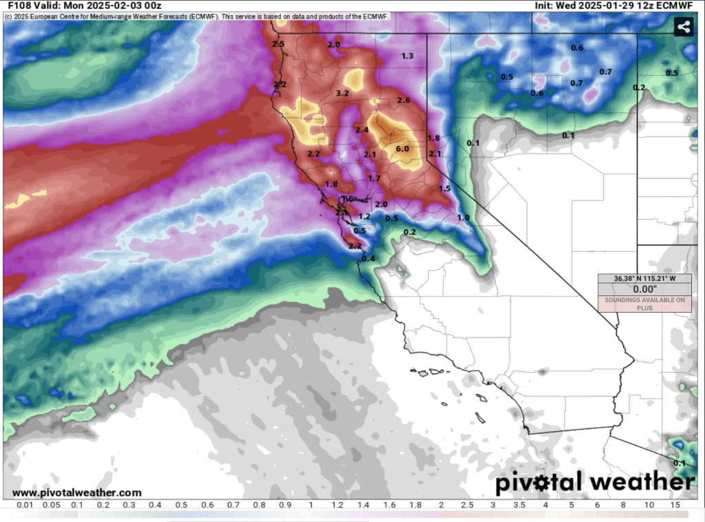
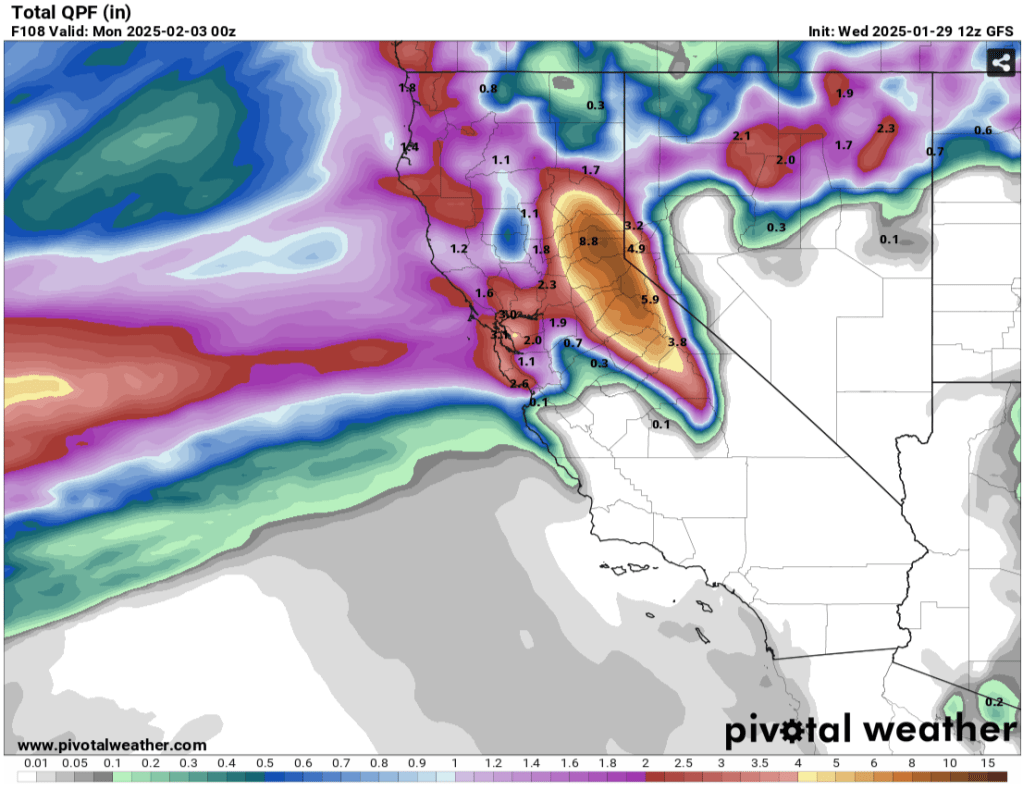
    Latest model runs show the potential for precip. amounts between 3″ to nearly 8″ of liquid in the Tahoe Basin through Sun (2/2) at 4pm.

    And that could be just the start.

    Euro model of total precip. through 2/2 at 4pm PST
    GFS model of total precip. through 2/2 at 4pm PST

    While nearly all of this will fall as rain below 8000′, a couple feet of heavy, dense cement could fall in the backcountry above 8500′ depending on how quickly snow levels begin falling on Sat. night and Sun.

    Rain and high elevation snow continue through Sunday, possibly letting up Sun PM through early Mon (2/3), before additional rounds of rain and snow take aim on the Sierra. Snow levels look considerably lower Mon. and Tues., possibly bringing snow down to 6000′.

    Much uncertainty remains in the forecast as noted by the above model discrepancy. A shift in the position of the main moisture plume by just 100 miles N or S could make a huge difference in the amount and type of precip. that ends up falling in the Tahoe backcountry.

    Either way, dry January has considerably degraded and weakened the backcountry snowpack. Surface snow exposed to prolonged periods of cold, very dry air has faceted into a poorly bonding surface, a future weak layer. A significant avalanche cycle is likely to accompany this round of storms as new loads of rain and snow stress the existing snowpack. On the flipside, a big avalanche cycle followed by significant heavy, wet snow accumulations may be just the recipe to “wash out” and restrengthen the snowpack for the rest of the season. Time will tell.

    Share this:

    • Share on Reddit (Opens in new window) Reddit
    • Email a link to a friend (Opens in new window) Email
  • Light and dry

    January 27th, 2025

    0400 temp. at 6350′ in Carnelian Bay: 22.6 deg. w/ 73% RH and 15.3 deg. dew point

    0515 temp. at 8650′ Mt. Rose backcountry TH: 10 deg.

    Backcountry obs.:

    It’s not often that storms deliver a foot of Utah-like blower pow to Tahoe. It’s even rarer for a storm to deliver almost entirely on the east side of the lake, with nearly nothing on the crest. The storm over the past weekend delivered both rarities.

    On Sun morning (1/26) the Rose backcountry hosted anywhere from 10-14″ of light, dry powder as light snow continued falling throughout the morning with generally light winds. Near and below treeline, delicate, blower powder adorned each tree branch and smoothed out every abuse and imperfection in the haggard, weeks old snow surface. Despite the quantity of new snow, the incredibly light density skied as though nearly nothing rested atop. What deceit!

    Beware: sharks lurk! Stumps and rocks previously visible above the snow, are now buried beneath a foot of pixie dust that behaves more like thick surface fog from a smoke machine on a dance floor than a riding surface.

    As such, the new snow bonded poorly to old surfaces creating plentiful sluffing in steep terrain, but not enough to entrain a skier or bury a person.

    By Monday morning, continued cold temps kept the snow light, fluffy and barely notable underfoot below treeline. Near treeline, N-E aspects had subtle wind effect and some very light rime atop the new snow, adding a bit more density underfoot between skier and hard surfaces beneath. Above treeline zones on N-E aspects were largely wind scoured down to cold, hard crusts.

    Weather and forecast thoughts:

    The storm that dropped the surprise amount of powder slowly exited the region early this morning (1/27) leaving cool temps, clear skies, and building inversions in its wake. Cold temps should prevail in the backcountry throughout the week.

    By next weekend, models now agree on a pattern change bringing Pacific moisture back to the Sierra starting over the weekend and possibly persisting into the following week.

    Details are still hazy regarding timing, intensity, and snow levels. However, at this point the first round looks relatively mild with snow levels at or above lake level, at least initially.

    As the pattern evolves, cooler air may filter into subsequent disturbances later next week, bringing snow levels down.

    Uncertainty is still high regarding details, but for now, it looks like the atmosphere may indeed crack a cold one to commemorate the end of dry January.

    Share this:

    • Share on Reddit (Opens in new window) Reddit
    • Email a link to a friend (Opens in new window) Email
←Previous Page
1 … 12 13 14 15 16 … 45
Next Page→

Create a website or blog at WordPress.com


Loading Comments...
 

    • Subscribe Subscribed
      • Tahoe Backcountry Snow
      • Already have a WordPress.com account? Log in now.
      • Tahoe Backcountry Snow
      • Subscribe Subscribed
      • Sign up
      • Log in
      • Report this content
      • View site in Reader
      • Manage subscriptions
      • Collapse this bar