Skip to content

Tahoe Backcountry Snow

  • Summer 2026 Forecasting JournalSeasonal forecasting narrative and journal.
  • Current Wx. at 7650′Current weather station info at 6350′ in Carnelian Bay.
  • About
  • Glossary of Terms
  • Archive
  • Wily storm(s) en route

    November 12th, 2025

    4:49 wx. at 6350′ in Carnelian Bay: 41.7°F / 31.5°F dew point / 67% RH

    Backcountry conditions:

    Yesterday I headed out to sample trail conditions on Donner Summit. On all but the shadiest aspects above 8000′, bare ground prevails. Multiple rounds of fall rain and melted snow have maintained tacky trails and running water, making for delightful biking and running. When the snow does finally fall, it’ll encounter highly saturated ground, a plus for bonding. N and NE aspects above 8000′ still host limited, lingering snow from previous storms.

    Warm days and cool nights, especially in valleys and depressions, have dominated the weather recently. Lows in the mountains have struggled to approach freezing, while colder temps and freezing fog settled into places like Martis and Olympic Valleys. This relatively warm, quiet pattern is all about to change and so too will the mode of transport for accessing the backcountry: goodbye running shoes, hello ski boots.

    Weather and forecast thoughts:

    Beginning today (11/12) clouds will begin replacing sunny skies, along with increased winds, followed by rain and higher elevation snows mainly Thurs-Fri (11/13-11/14). Snow will likely mix in down to lake level overnight Thurs into Fri, but is unlikely to accumulate in any significant way. Through Sat AM (11/15), snow accumulations from 3-8″ above 8000′ are possible with the highest amounts falling along the crest and south from Carson to Ebbetts Pass. A foot of snow in the backcountry isn’t out of the question, especially in the higher zones along the Crest south of Tahoe. Around the lake .5 – 1″ of liquid looks most likely to fall with the highest amounts west and the lowest amounts east.

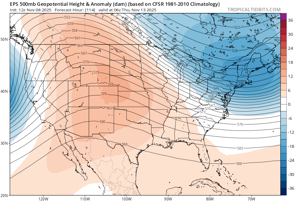
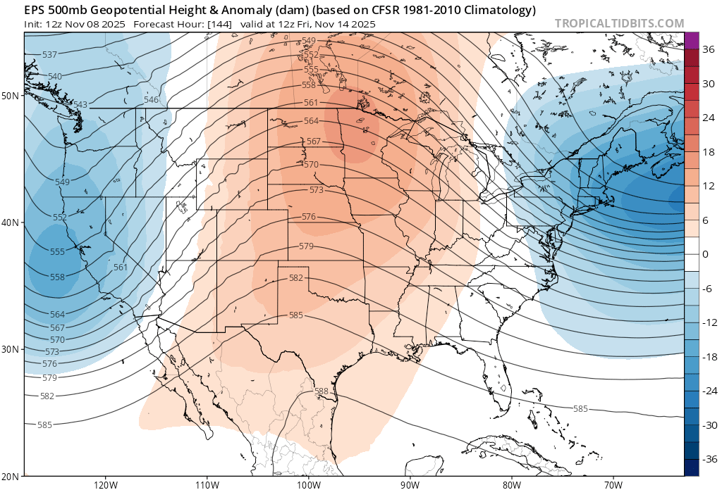
    Even 24 hours out, confidence in the forecast of this storm remains moderate at best. The incoming storm, the low, becomes cut-off from the main jet stream as it drops off the CA coast, then wanders ashore south of LA this weekend.

    Here’s a big picture look at this process from halfway up in the atmosphere (500mb).
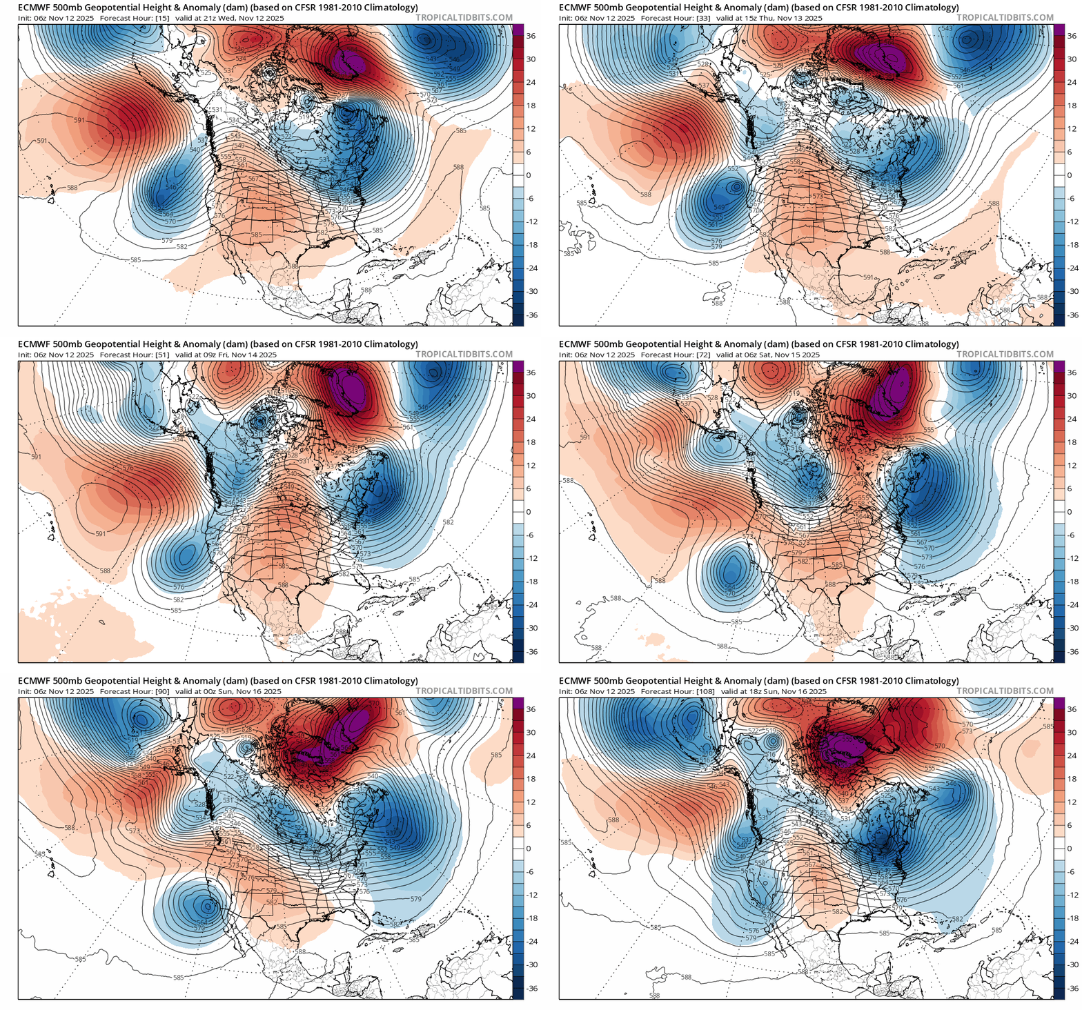
    Rather than riding along with the jet stream on a fairly predictable path, the low pinches off and then wobbles around, stuck between the main steering currents in the atmosphere. (Blues represent lower pressure heights and reds higher pressure heights. Note the closed lines around the CA coast.)

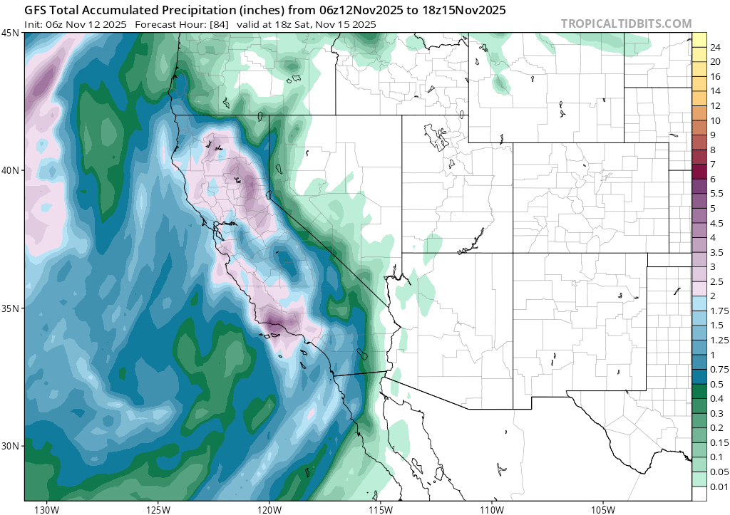
    Returning to the storm at hand, there’s still quite a bit of spread in precip amounts and snow levels, especially between the Euro and GFS models with the GFS more bullish on total precip amounts through Sat (11/15) than the Euro:
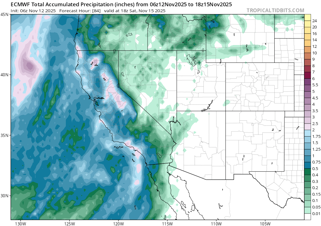
    ECMWF total precip through 10AM PST on 11/15
    GFS total precip through 10AM PST on 11/15

    Over the course of the lead up to this storm, the Euro has tended to pickup on the evolution of the forecast more quickly than the GFS, but throughout the whole process, the GFS has remained more bullish on precip amounts. It’s going to be an interesting couple of days to see what actually pans out.

    But there’s more! Looking beyond Saturday, another round of rain and possibly more snow could re-enter the picture around the beginning of the work week. And models show more storms potentially coming in through after that.

    Despite all the forecast variance, it’s safe to say that the days of the nearly perfect fall are quickly coming to a close, soon to be replaced by cool, unsettled weather and the long awaited return to sliding on snow.
    Share this:

    • Share on Reddit (Opens in new window) Reddit
    • Email a link to a friend (Opens in new window) Email
  • Stellar fall continues, but with a potential end in sight

    November 8th, 2025

    14:14 wx. at 6350′ in Carnelian Bay: Clear skies / 54.3°F / 44.4°F dew point / 70% RH / weekly precip.: .51″ rain

    Backcountry conditions:

    Another fall storm passed through the Tahoe Sierra this past week breaking up a nice stretch of calm, clear weather with intense winds followed by valley rain and high elevation snows. Snow fell for most of Thurs (11/6) above 7500′, but due to high SWE values of around 5:1, only a few inches of thick, wet cement pasted backcountry peaks. Below 7500′ another wetting rain dropped anywhere from less than 1/2″ to over 1″ of rainfall, recharging the amazingly tacky dirt trail conditions. Fall foliage across the Basin is long gone, but pungent smells of decomposing leaves and vegetation still fill the air with fall flavor.

    South facing peaks are devoid of any snowpack, but north faces have held onto snow along the Sierra Crest and in the Mt. Rose area since the first flakes fell back in October. This week’s storm added yet another layer of thick frozen paste to the superficial snowpack. Few zones hold enough snow to make turns, but the meager coverage is worth remembering: once buried by the first decent dumps of the season, these zones could harbor persistent, deep instabilities.

    Weather and forecast thoughts:

    While Tahoe currently enjoys quiescent fall conditions with highs in the 50s and lows in the 30s under clear skies and calm winds, models are in good agreement for what could be the first snowpack inducing storm(s) of the season, at least for the mid to upper elevations, around mid to late week (11/12-11/14) and into the following weekend.

    Model ensembles show good agreement in the upcoming changes through the end of next week as noted by the arrival of an upper level trough overnight Weds – Fri (11/12-11/14).

    EPS ensemble showing storm arrival Weds night into Thurs (11/12-11/13)
    Friday morning (11/14) showing a trough centered off the Monterrey Bay.

    While models do largely agree on a significant storm mid/late week, the exact impacts are still somewhat hazy and changing with each model run.

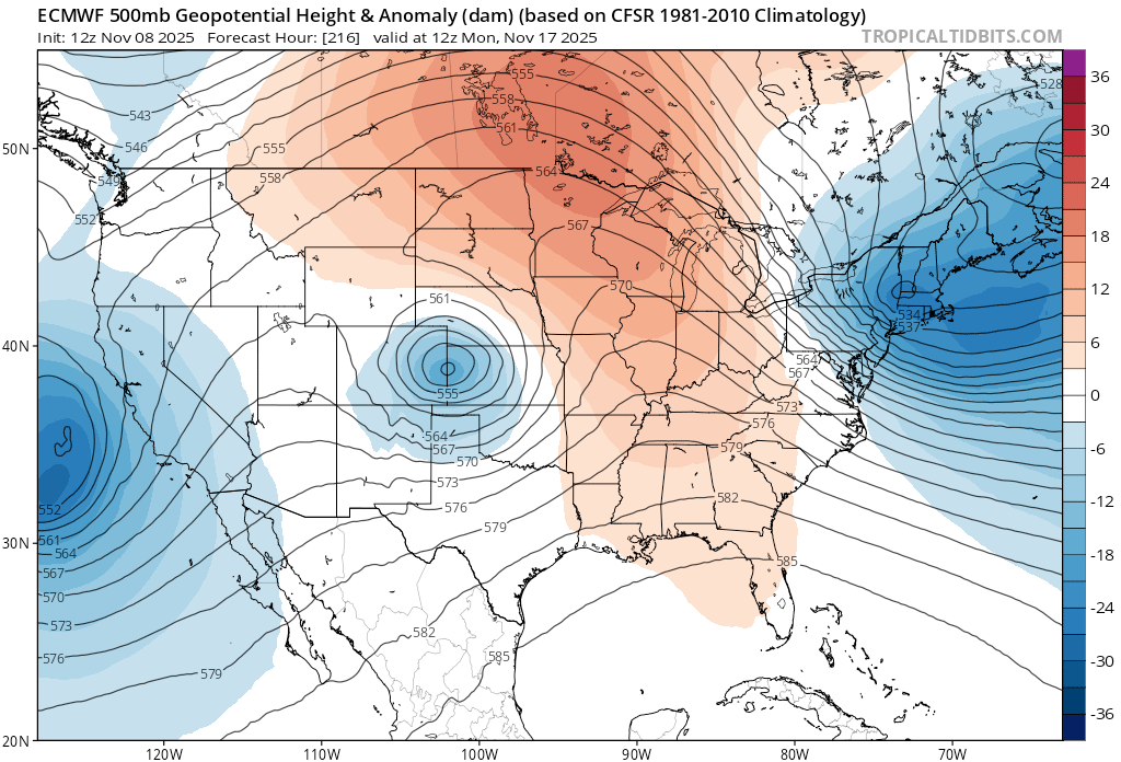
    Looking at late next weekend, the picture becomes more muddled with the Euro model showing a cutoff low (notoriously difficult to forecast) dropping off the CA coast:

    4am PST on Mon, 11/17.

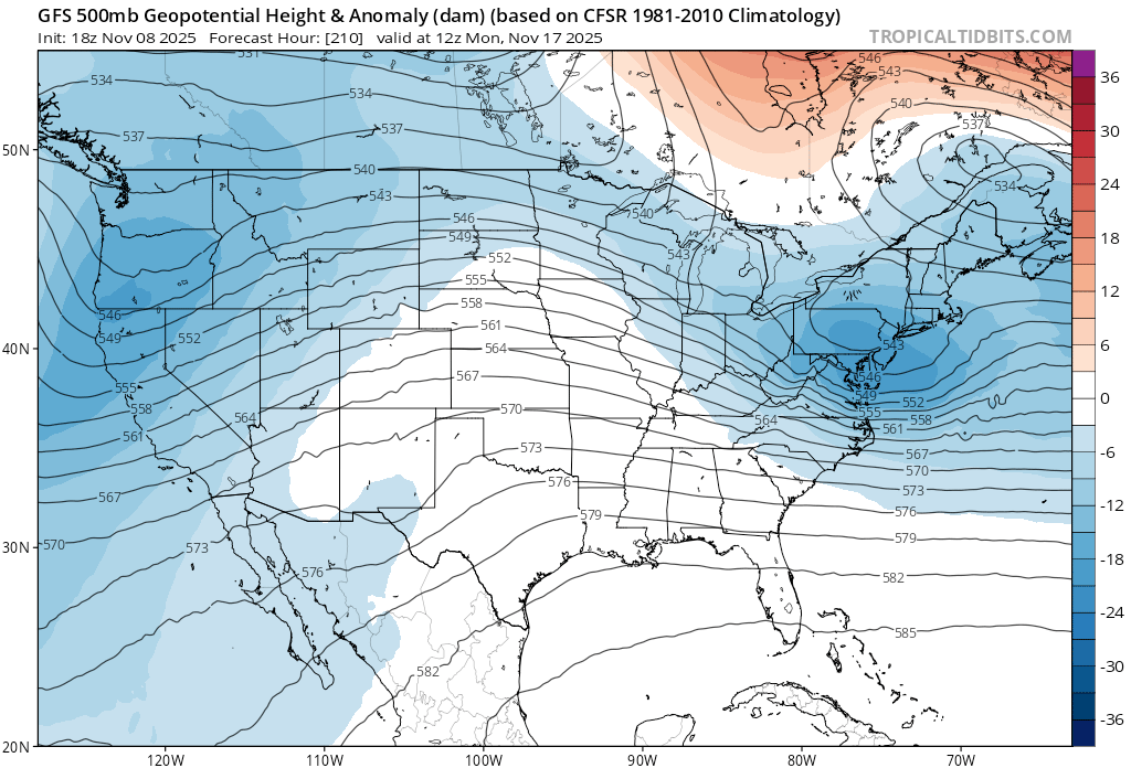
    And the GFS showing a broader trough encompassing most of the west coast:

    4am PST on Mon, 11/17.

    More details are sure to emerge in the coming days. Until then, the trails are still at their fall best, so get it while you can.

    Share this:

    • Share on Reddit (Opens in new window) Reddit
    • Email a link to a friend (Opens in new window) Email
  • Weekend of 10/24: beneficial fall rains, negligible snow

    October 23rd, 2025

    Backcountry obs.:

    Snowfall from last week’s storm has melted in all but the highest north facing areas around Tahoe. Trail conditions are superb with minimal dust, tacky, springy dirt, and water running again in the most established stream beds. Cruising the trails, it’s impossible to ignore the pungent smells of fall: decaying leaves and wet ground. Fall colors are also more stunning than they’ve been in years with aspens, cottonwoods, and even maples, showing their most vibrant yellows, golds, and oranges. Right now a trip into the backcountry is a total sensory experience.

    Weather and forecast thoughts:

    What a week ago looked like a solid signal for significant precip., has now fizzled into a dreary weekend of rain showers, cool temps, and blustery conditions. Models throughout the week have trended drier and warmer, pushing the bulk of the energy to our north into the Pacific NW.

    Here are some visuals from the models:

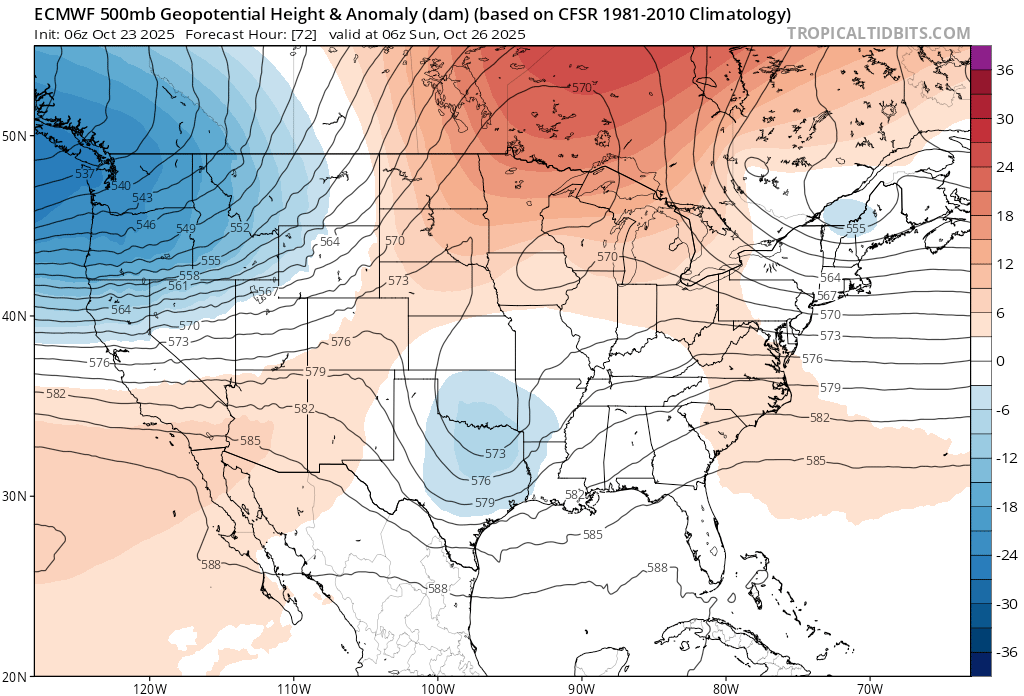
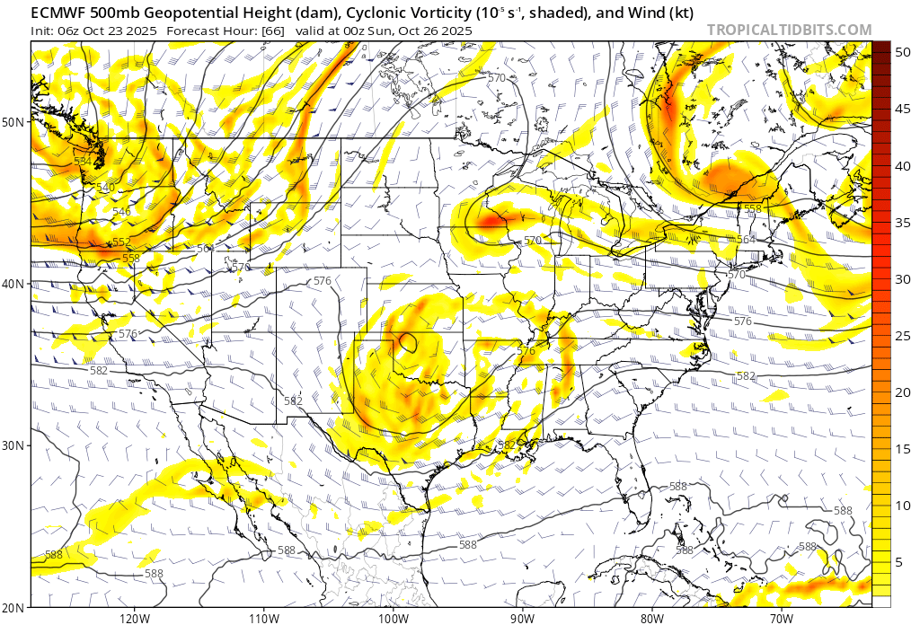
    Saturday, 10/25 at 1700 PST. Low pressure misses NorCal as noted in 500mb height anomalies.
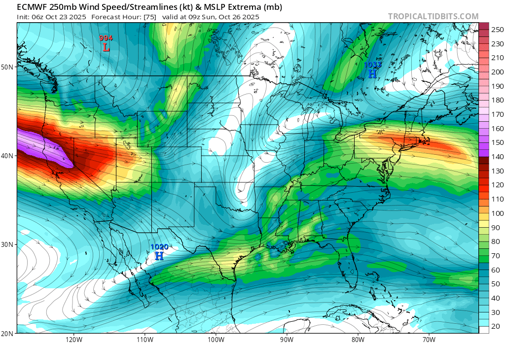
    NorCal right in the thick of a 150kt upper level jet at 0200 on 10/26 PST bringing gusty winds, especially over higher terrain.
    Mid level vorticity around 1700 on 10/25 PST showing the bulk of the forcing energy confined to the PacNW.
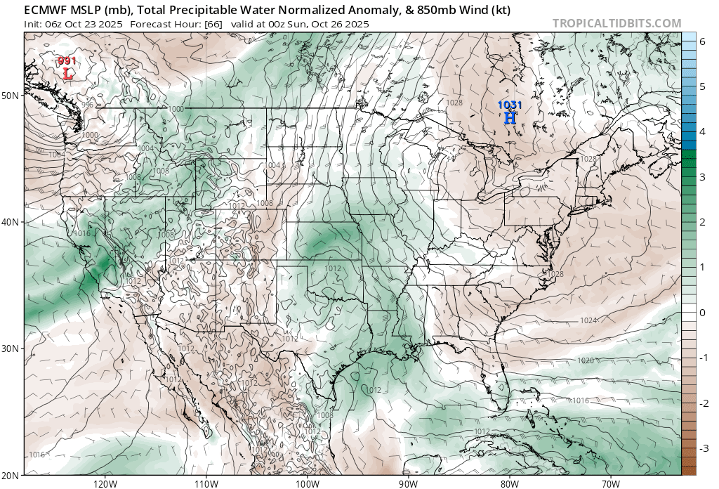
    Total precipitable water, PWAT at 1700 PST on 10/25. Decent amounts (~1″) of available moisture in the atmosphere, but without significant dynamic forcing as noted in the above vorticity product, actual amounts will likely be far less at the surface.

    For the coming weekend, expect rain on both days with the majority falling Sat. and Sat. night. Strong SW breezes will accompany the rain on Saturday, then back off on Sun. as precip. tapers to showers under cloudy skies. Highs both days will be raw: mid 40s at lake level. Some snow can be expected on the highest passes and peaks above 8500′ with just a few inches of accumulation expected. In total, that Tahoe Basin has a 50% chance of receiving up to .50″ of liquid with the highest chances and highest amounts favored the further north you travel.

    Behind this system high pressure returns with sunny skies and above average fall temps going into early November. Winter must wait, but in the meantime, the coming rains ensure that a stellar autumn continues.

    Share this:

    • Share on Reddit (Opens in new window) Reddit
    • Email a link to a friend (Opens in new window) Email
←Previous Page
1 … 11 12 13 14 15 … 53
Next Page→

Create a website or blog at WordPress.com

Loading Comments...
  • Subscribe Subscribed
    • Tahoe Backcountry Snow
    • Already have a WordPress.com account? Log in now.
    • Tahoe Backcountry Snow
    • Subscribe Subscribed
    • Sign up
    • Log in
    • Report this content
    • View site in Reader
    • Manage subscriptions
    • Collapse this bar