Skip to content

Tahoe Backcountry Snow

  • Summer 2026 Forecasting JournalSeasonal forecasting narrative and journal.
  • Current Wx. at 7650′Current weather station info at 6350′ in Carnelian Bay.
  • About
  • Glossary of Terms
  • Archive
  • Subtropical parade; it’s good for the fish

    December 16th, 2025

    Backcountry obs:

    0545 Wx. at 8750′ in the Mt. Rose backcountry: 37.1°F / dew point: 7.4°F / RH: 30.3°F / calm winds / snow depth: 0-12″ depending on aspect

    A tour of the Rose bc around dawn on 12/15 revealed a nearly unusable snowpack below 9000′ on all but the most northerly, shaded aspects. It’s grim, bottom of the barrel skiing out there. Above 9000′ coverage improves, but it’s very low tide after nearly 4 weeks of warm, dry weather atop a thin, early season snowpack. Surface conditions are highly variable and very skied out in popular zones. The most southerly, solar aspects at high elevations present some “baby corn” melt freeze surfaces, while mixed shade areas host breakable crust atop nearly 8-10” of loose, dry facets. True northerly, sheltered zones have soft, crust free, faceted snow down to the October storm interface.

    Aside of the nearly unskiable nature of the current snowpack, the abundance of loose, faceted snow beneath surface crusts and across northerly aspects raises the alarm for future deep instabilities once snow does arrive.

    Weather and forecast thoughts:

    A pattern change heralding the end of steep inversions and warm, sunny days across the upper elevations is upon us. This week, rounds of very moist systems will begin impacting the Tahoe Sierra starting today (12/16) through Weds (12/17), and again late Fri (12/19) through the weekend into next week. The parade will continue on and off through at least Christmas, and likely beyond.

    While current guidance favors high precip. amounts throughout the period, above average temperatures and stubborn warmth will likely plague each system into early next week. High snow levels, especially with the first two systems, will keep snow confined to the highest elevations: 8000′-9000’+. There’s not a ton of real estate in Tahoe at those elevations, so for most zones, this won’t be beneficial for the snowpack.

    Models are in fair agreement on the positioning of precip. through Sunday evening (12/21). Here’s the Euro ensemble of total precip through Sunday at 1600 PST.
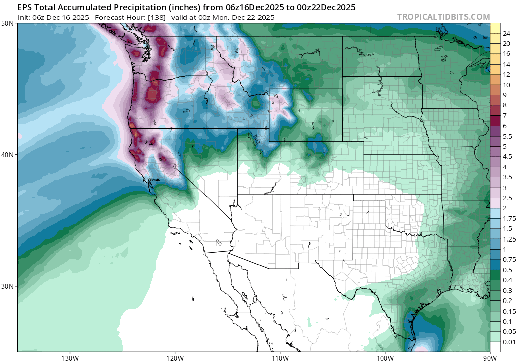
    Total liquid precip. through Sun, 12/29 at 1600 PST.

    In addition to the agreement on precip., guidance continues to favor well-above average temperatures through the weekend.
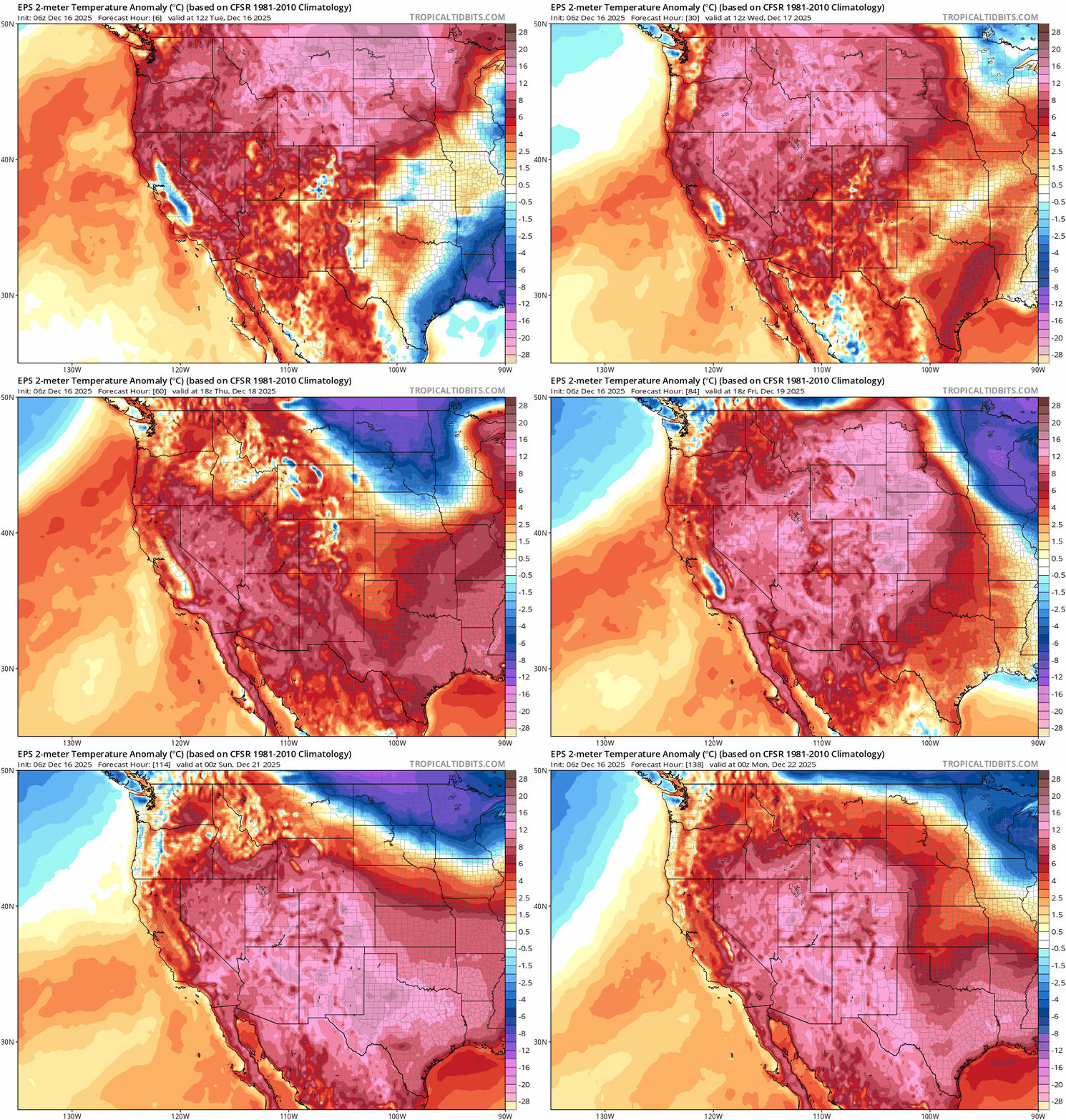
    Ground level temperature anomalies through Sun., 12/21 at 1600 PST.

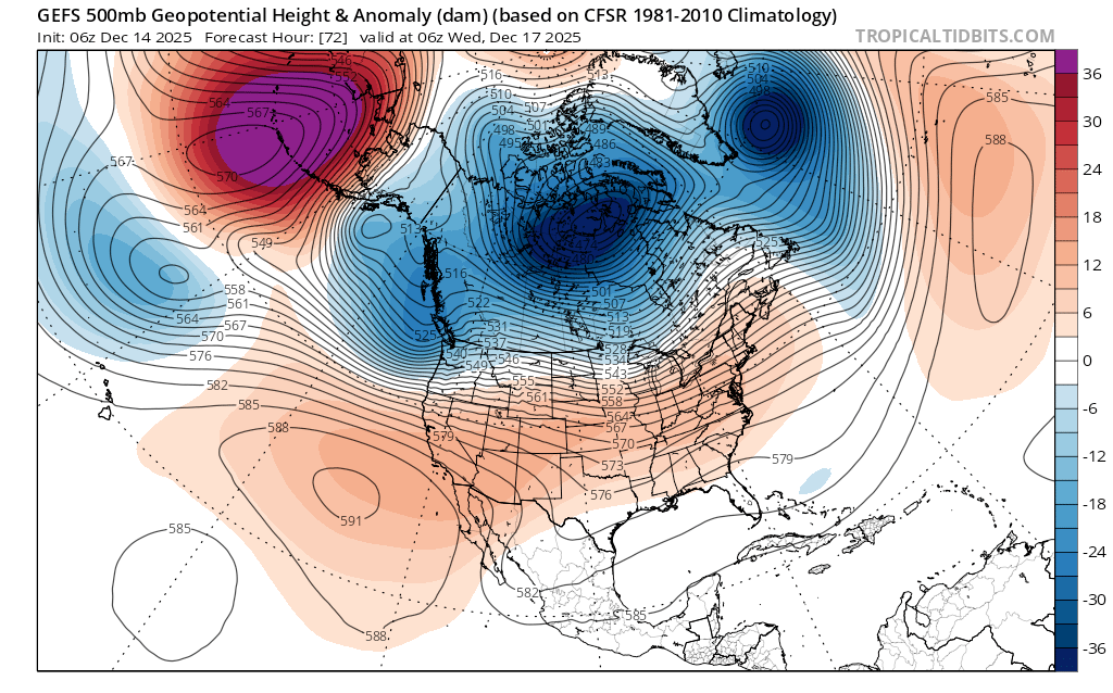
    Why so much warmth? Much of it can be attributed back to the stubborn ridge of high pressure from the recent pattern and its affect on the jet stream. Looking at the Euro forecast of the 500mb height anomalies, the ridge doesn’t depart completely. Rather, it flattens and sags south as the trough of low pressure to the north slowly nudges its way southward.
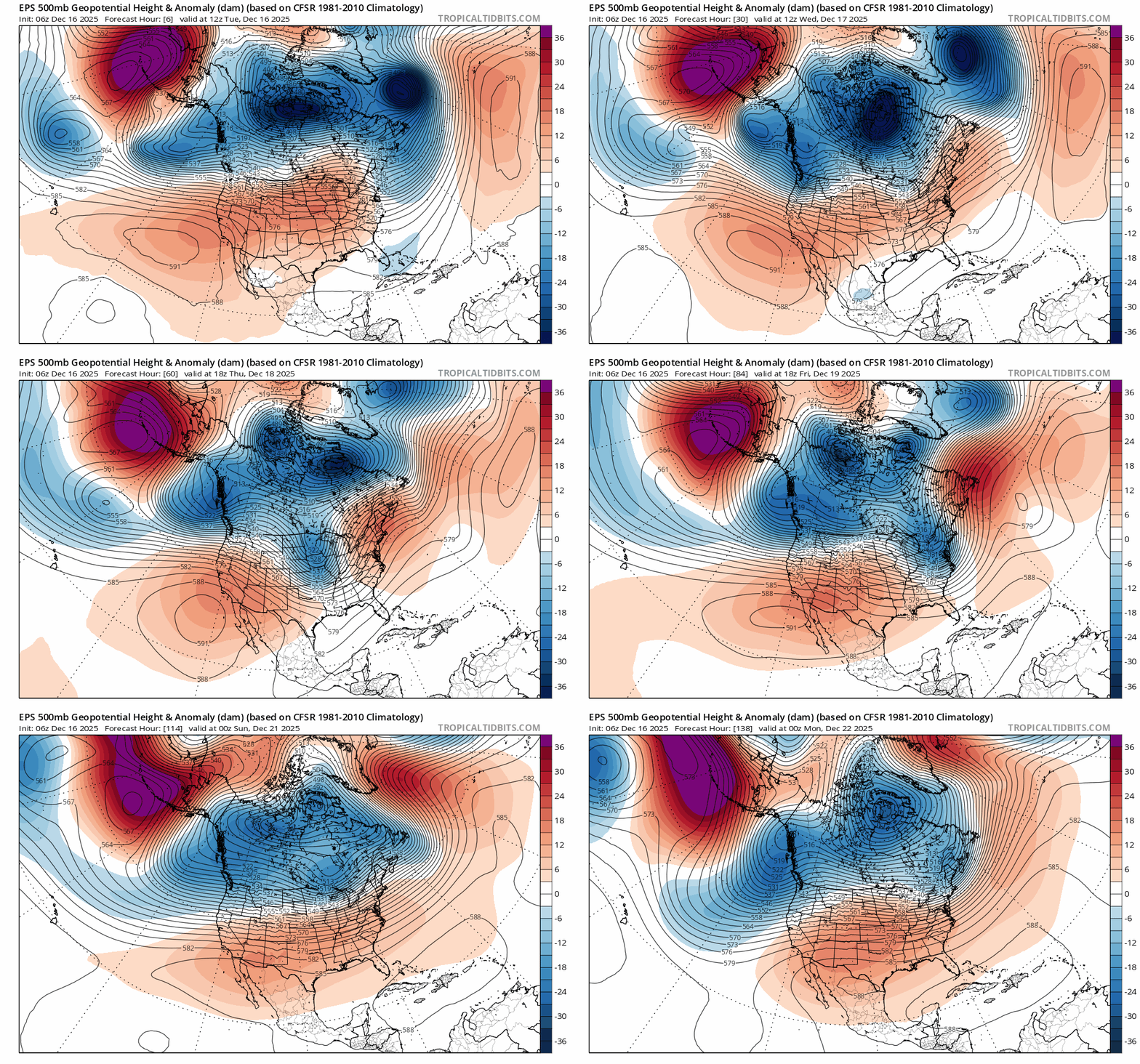
    500mb height anomalies showing troughing (blue) and ridging (red) through Sun., 12/21 at 1600 PST.

    The the white area between the blue and red creates a direct alley to the SW, and that’s where the moisture feed for the storm parade originates for the coming week. Here’s a look at the precipitable water and low level (850mb) winds across the Pacific, showing the moisture fetch with a clear AR signature over the weekend.
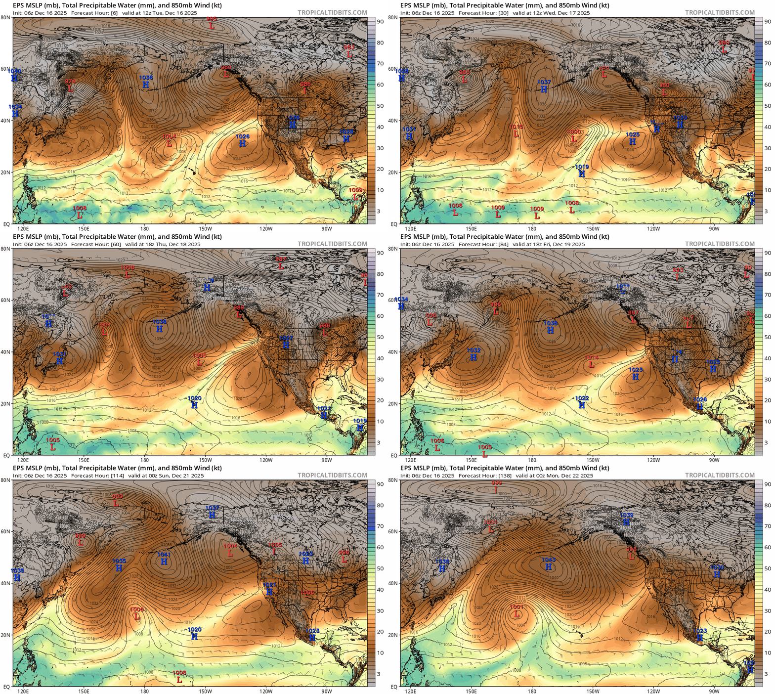
    Even though the ridge flattens and begins making way for the trough and its associated cold air, Tahoe remains on the northern periphery where the jet is able to funnel copious amounts of warm moisture from the subtropics.

    What’s more, sea surface temperatures (SSTs) in the eastern Pacific continue to be well above average. These anomalies also align with the fetch of moisture for the coming week, imparting additional warmth for the systems.
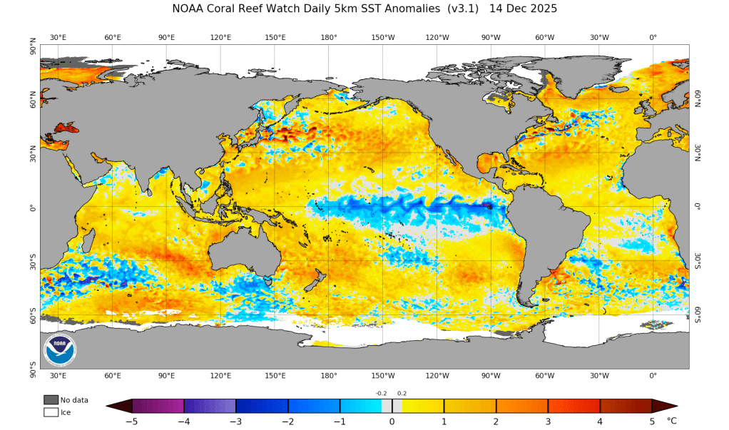
    Global SST anomalies as of 12/14/25.

    Unfortunately, warmer than average SSTs will likely act as a background warming influence for storms throughout the season.

    Looking ahead into Christmas week, most models suggest that the trough progresses further south into CA, bringing colder temperatures, lower snow levels, and additional storminess. However, this is delayed from what models suggested a few days ago, so the arrival of cooler air might take some time.

    So as an old fly fishing friend used to say to me as I grumbled through warm storms, “it’s good for the fish.” The mostly-rain event over the coming week will entertain the fish with higher flows, but continue to frustrate any skiers hoping for a snowpack before Christmas.
    Share this:

    • Share on Reddit (Opens in new window) Reddit
    • Email a link to a friend (Opens in new window) Email
  • Incredible warmth with relief in sight

    December 14th, 2025

    Backcountry obs:

    The unrelenting ridge of high pressure responsible for weeks of warm, dry weather in the mountains and cool, clammy conditions in the Tahoe Basin has taken a heavy toll on the snowpack. Snow has melted back to dirt across the area except on the highest, most sheltered N and E facing zones above 9000′. Non-snow sports have been the preferred source of outdoor fun recently.

    A morning run yesterday (12/13) along the Incline Village skyline revealed only scattered patches of snow on southerly aspects and steeply inverted temperature gradients. At 5:30am it was 31°F at lake level under dense fog and 44°F at the 7600′ TH beneath Rifle Peak!

    Looking NE towards Incline Peak and Slide Mountain on 12/13/25.

    Fortunately, a pattern change is in store over the next week that will kick out the inversions and usher in more unsettled weather and the chance of higher mountain snows towards week’s end. The peak of this early season low tide is in sight.

    Weather and forecast thoughts:

    The coming week (12/15-12/19) will likely start out warm and dry through most of Tuesday (12/16) before rain filters into the region Tues PM through Weds, breaking Thurs, then returning Fri through the upcoming weekend. Temps in the mountains above 7000′ will start out warm with highs in the 40s early in the week, before cooling off into the 30s towards week’s end as cooler air slowly filters in from the north. Despite the new rounds of precip., models are in good agreement that high snow levels through the work week won’t provide much opportunity for the snowpack to rebound, except in zones above 8000′-9000′.

    Looking into next weekend and Christmas week, models do suggest a trough developing off the CA coast which would bring more storminess, but with colder temps and lower snow levels, potentially setting up the backcountry for the season. Just like in the late fall, it’s a good idea to take note as to which areas have snow and which are snow free to help understand potential instabilities once a new snowpack finally arrives.

    Here are some visuals depicting the changes afoot this week and into Christmas week:

    500mb heights at 2200 PST on 12/16 show the ridge of high pressure flattens, but Tahoe remains on the N side keeping temps warm.
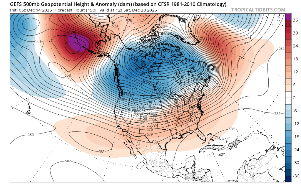
    By early morning (0400) on 12/20 the trough makes slow progress S towards. Tahoe, potentially bringing colder air and lower snow levels.
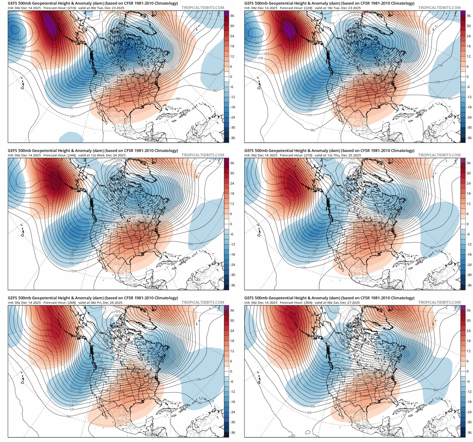
    500mb height animation shows trough progression off CA 12/23-12/27.
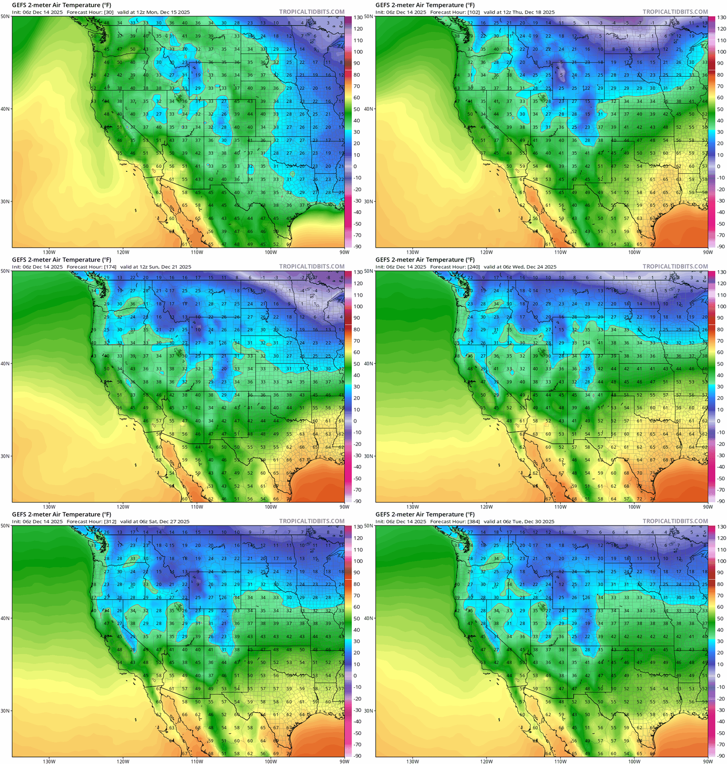
    GEFS ensemble animation of ground level temps from 12/15-12/30. Warm air is slow to retreat through 12/23.
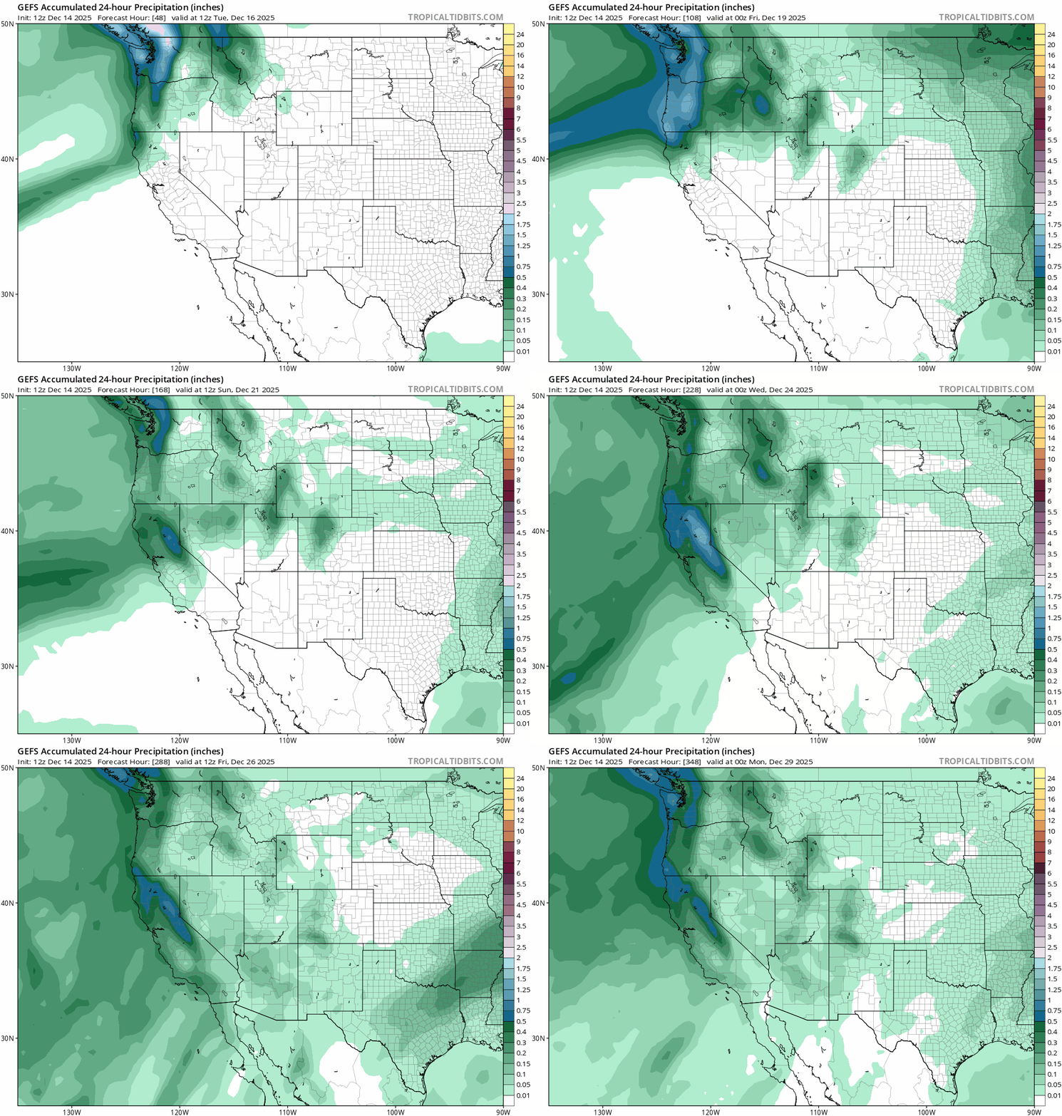
    24 hr. liquid precip. starting 12/16 – 12/29 showing pulses of storminess throughout the period.

    While the potential return of snow is still more than a week out, these are the most encouraging signs of winter’s arrival seen all season.

    Share this:

    • Share on Reddit (Opens in new window) Reddit
    • Email a link to a friend (Opens in new window) Email
  • Warm and dry: beefy ridge takes up residency near CA blocking winter’s arrival

    December 6th, 2025

    Site note: Current Carnelian Bay weather info is now linked in site navigation.

    Backcountry conditions:

    0500 temp. at 8650′ Mt. Rose backcountry TH: 27°F / clear skies / light winds

    0630 backcountry wx. ob. at 9600′ in Mt. Rose backcountry: 29.5°F / 14.2°F dew point / clear skies / moderate N winds

    A predawn sampling of the state of the backcountry on Friday (12/5) in the Mt. Rose area revealed a variable, threadbare, and battered snowpack with areas of soft bliss hiding out in high elevation sheltered nooks and crannies.

    Below 9000′ the snowpack is barely usable with anywhere from 6-8″ of variable base with sharks protruding everywhere. Coverage improves considerably above 9000′ with 12-18″ of base, but larger shrubs, rocks and stumps lurk in the low tide conditions. Don’t trust the lumps!

    Popular zones in the Mt. Rose area all show signs of the public’s enthusiasm to ski on anything white as dozens of skin tracks meander across the forest, all converging at the summits. Along the most trafficked routes, a skier-packed hard surface has actually improved skiing, creating a consistently dense, fast and edgeable surface. Away from the skier highway, surface conditions vary with solar aspects hosting hard-frozen crusts, dirt and bushes, transitional aspects holding strenuous breakable crust, and the most sheltered NE high elevation zones still harboring cold, soft degraded facets. Soft fluffy turns exist for those willing to seek. The backcountry is worth stretching the legs, as long as you have a higher risk tolerance for breaking gear and/or bones.

    Weather and forecast thoughts:

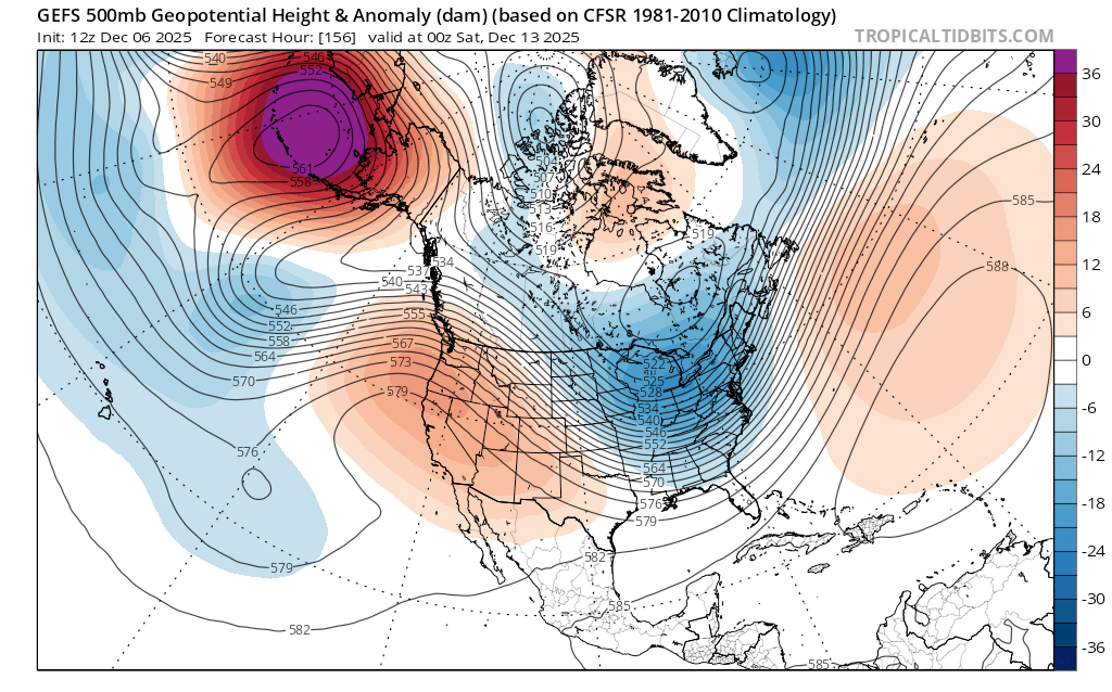
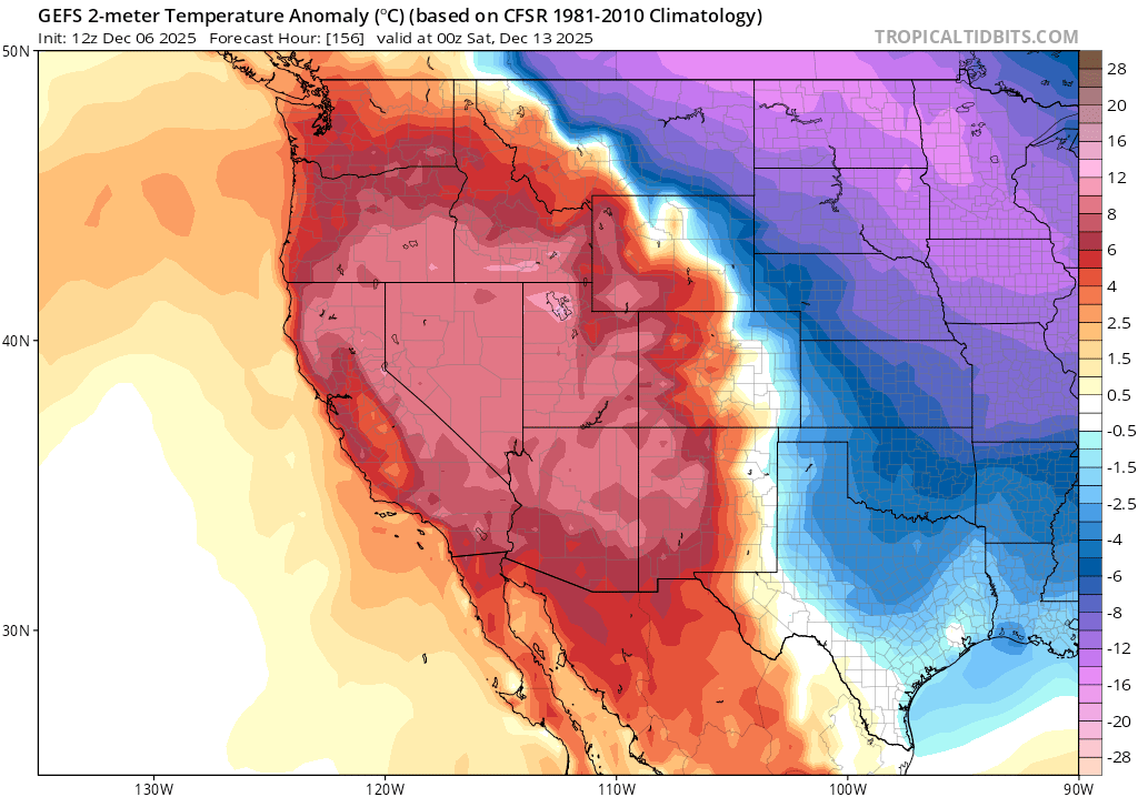
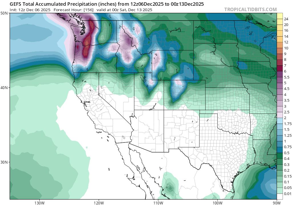
    The current warm and dry pattern will continue for the foreseeable future. Through the coming week, the dominant ridge of high pressure over the eastern Pacific will hold strong, blocking storms from reaching CA and sending disturbances into the PacNW. Through Friday (12/12) model ensembles keep the Sierra warm and bone dry.

    Blocking ridge of high pressure over CA on the evening of 12/12.
    Well above average temps continue through 12/12.
    Completely dry from 12/6 – 12/12.

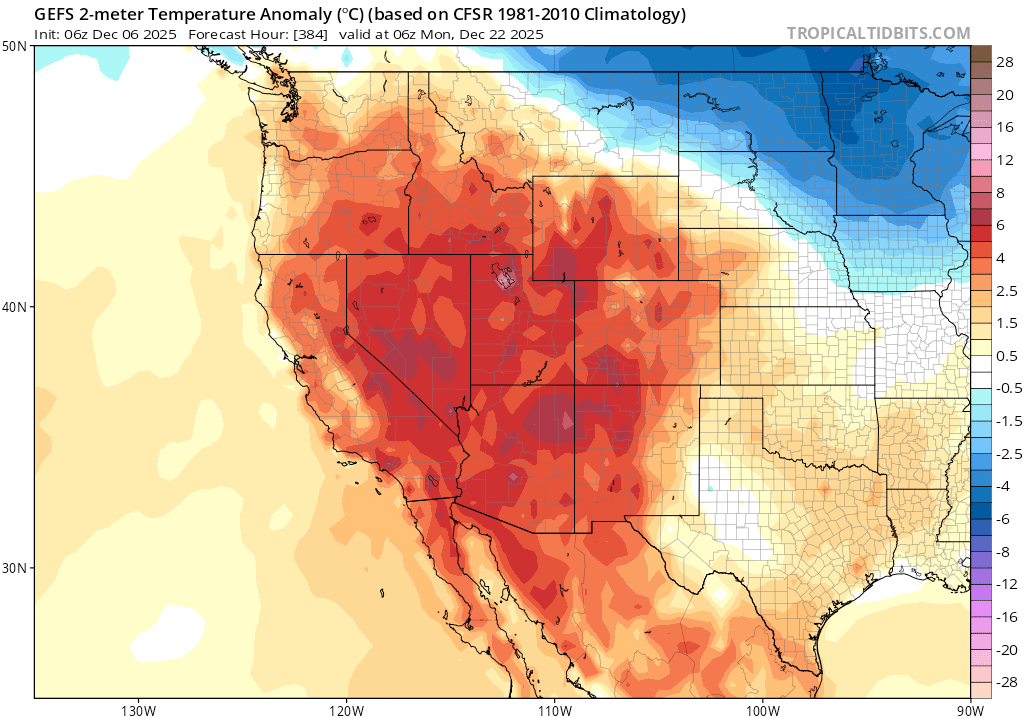
    Looking beyond the 12th, models do hint at storms attempting to make it into the Sierra through a marginally weakened ridge, but under solidly warmer than average air mass.

    Above average surface temps around 11pm PST on 12/21.

    In short, a ridge-busting signal into a cool and wet pattern bringing snow has yet to emerge in the long term forecasts going out towards Christmas. Keep on enjoying the climbing/running/biking/etc.

    All things must pass, but some take far longer than others.

    Share this:

    • Share on Reddit (Opens in new window) Reddit
    • Email a link to a friend (Opens in new window) Email
←Previous Page
1 … 9 10 11 12 13 … 53
Next Page→

Create a website or blog at WordPress.com

Loading Comments...
  • Subscribe Subscribed
    • Tahoe Backcountry Snow
    • Already have a WordPress.com account? Log in now.
    • Tahoe Backcountry Snow
    • Subscribe Subscribed
    • Sign up
    • Log in
    • Report this content
    • View site in Reader
    • Manage subscriptions
    • Collapse this bar