Nearly a week ago the season kicked off with a bang as the first significant snowfall blanketed the Tahoe Sierra. Snow totals from a few inches to over a foot in the Mt. Rose and Carson Pass areas blanketed the region. By late Tuesday, a few clips of folks ripping powder in the Mt. Rose area surfaced on the interwebs.
The October 13-15 storm was a quirky one that at one point around late afternoon on the 14th, brought snowfall and 33°F to lake level in South Lake Tahoe while it was around 6° warmer and raining in Carnelian Bay. South and Eastern parts of the Basin also picked up higher snow amounts than the traditional magnets on the NW side of the Basin. The Eastern Sierra from Ebbetts Pass down to the Mono Recesses picked up feet of snow while points north of Tahoe generally received less than a foot.
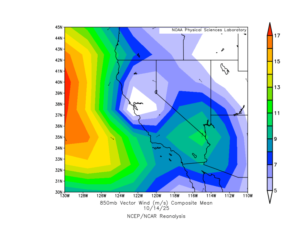
What happened? A look at the storm from the 14th is revealing. Here are the winds from the lower atmosphere.
Bands of rain and snow drenched Tahoe for most of the day of 10/14, but tracked in mainly from the SE. Looking at the position of the low, it’s easy to see how points south received more moisture with the flow off the Pacific bringing more rain and high elevation snow to the Central and Southern Sierra, while Tahoe received more of the wrap-around effect, with the Carson Range benefiting from enhanced upslope flow.
Since late week, skies cleared and temps have warmed considerably into the 60s around the lake, melting most of last week’s snow. Shady N and NE aspects above 8000′ still hold some residual crusty snow, with facets developing underneath.
It’ll be worth remembering these patches should they hold on until the next snow. Looking at the models, a potentially more potent storm with a solid moisture plume may impact the area next weekend, 10/24-10/26.
Until then, pleasantly warm, sunny days and cool nights are on tap for the coming work week.
1709 wx. at 6350′ in Carnelian Bay: Moderate rain / 49.6°F / 49.1°F dew point / 98% RH / total daily rainfall: .64″
Weather and forecast thoughts:
October 1 rang in the new water year with a few hundredths of an inch of rain and the wet parade continues to this writing with more than 1/2″ falling so far today. The bluebird beach days of late summer have recently been interrupted by cool, rainy and unsettled weather. Fall is quickly descending upon the Sierra and the first snows of the year are just around the corner.
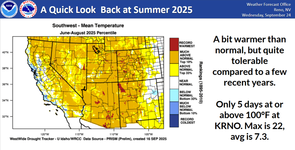
By Sierra standards, it was a great summer. Choking wildfire smoke and insufferable heat never really materialized. Temperatures averaged slightly above normal and while generally dry in the first half, the monsoon did eventually kick in, bringing rounds of wet afternoon thunderstorms in July and August. Just as trails were reaching peak dustiness, the sky provided relief. It’s been downright pleasant, a far cry from the searing heat and weeks of smoke from summers passed.
Credit: NWS Reno
Looking ahead to ski season 2026:
“Long range models are too good to ignore, but too unreliable to use.”
Over the past year I’ve been back in school completing a forecasting program at Penn State. Of all the exciting things I’ve learned, one that gives me the most pleasure is encapsulated in the above quote from someone over the years. Even with all the collective understanding of the science and new tools at our disposal, long range forecasting remains difficult. Accuracy diminishes significantly beyond five days, not to mention five months out. What is available does help to paint a general picture of what’s out there. Current technology allows us to see oceanic conditions and atmospheric circulations. But the atmosphere and its interplay with the oceans is chaotic. We simply don’t have the capacity to measure every air parcel of the atmosphere at every point in time, and then plug those observations into predictive models. What a joy to be so humbled and have so much yet to discover!
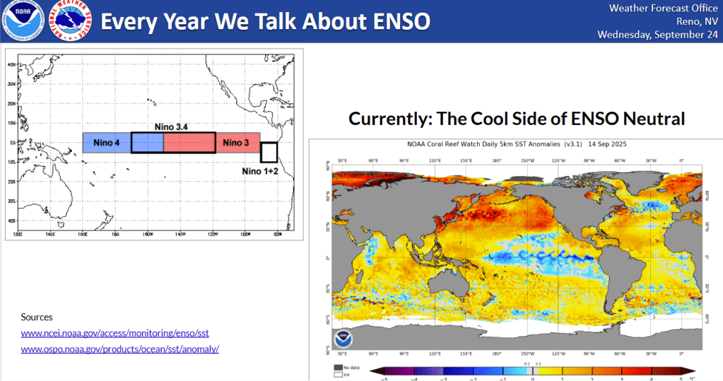
Looking at what’s on the table for the coming year, the tropical Pacific currently shows signs of a weak La Niña developing.
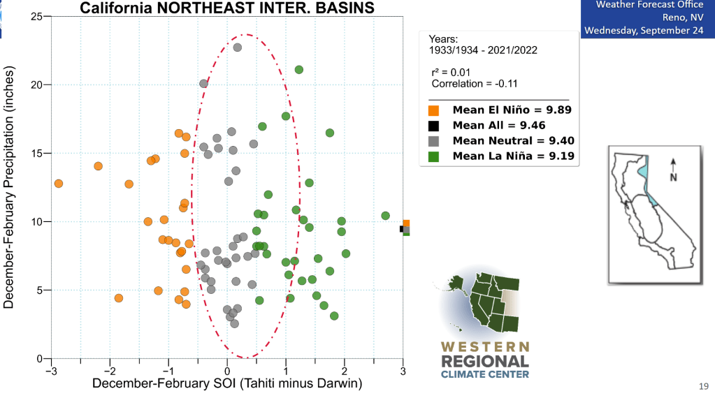
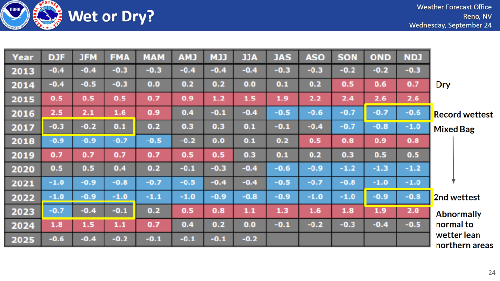
Despite the dramatic headlines, there is very little, if any, correlation between La Niña and wet or dry years in the Sierra. Take a look at the below graph showing Dec-Feb precipitation in El Niño, La Niña, and ENSO neutral conditions dating back to the mid 30’s.
It’s all over the map.
In the chaos of the atmosphere, ENSO is only one background variable of many different atmospheric circulations and oceanic conditions that can affect what we end up receiving in the Sierra. While it often receives so much attention – and rightly so for many parts of the world – the data don’t seem to bear out any strong signal for the Sierra.
Here’s another table to illustrate the point. The two biggest years of the past few decades actually came in during ENSO conditions similar to now that inspired more yawns than screams.
Credit: NWS Reno
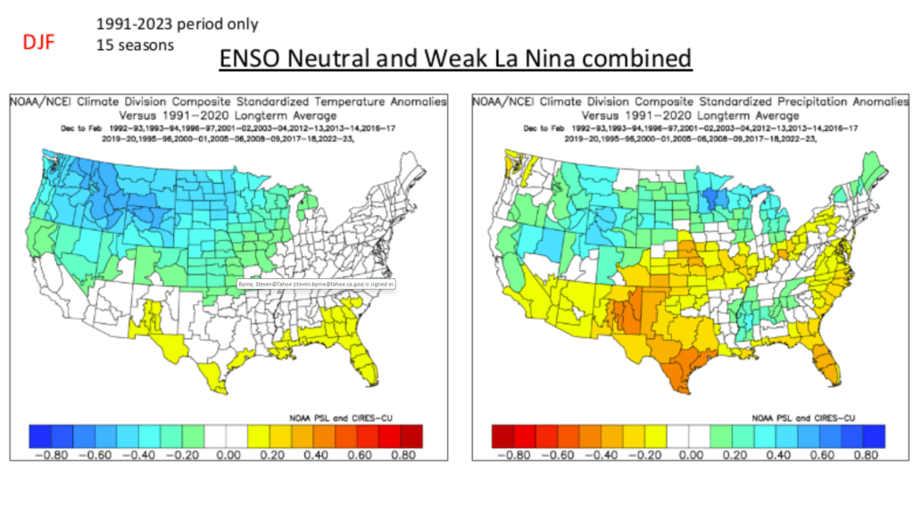
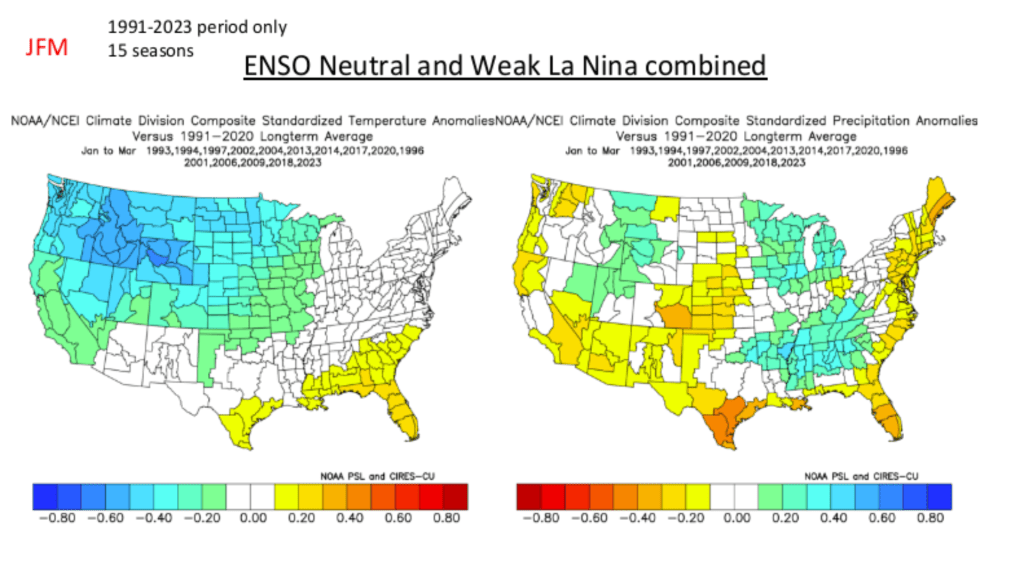
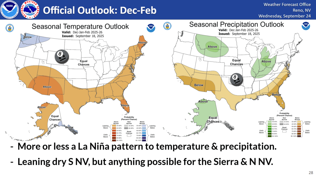
And here are some charts showing how ENSO conditions similar to what we’re currently experiencing play out seasonally for temperature and precipitation anomalies.
Can a big year happen? Sure. Can a mediocre or bad year happen too? Yep.
There’s simply too much chaos in the system and too much that we don’t yet know or understand to be able to accurately predict the season to come. The past does give insights, but the past also occurred in conditions with less total background global warming into the earth system. While we can do our best to model out thousands of scenarios, even using AI, we simply cannot account for all the variables and unknown unknowns lurking in the future.
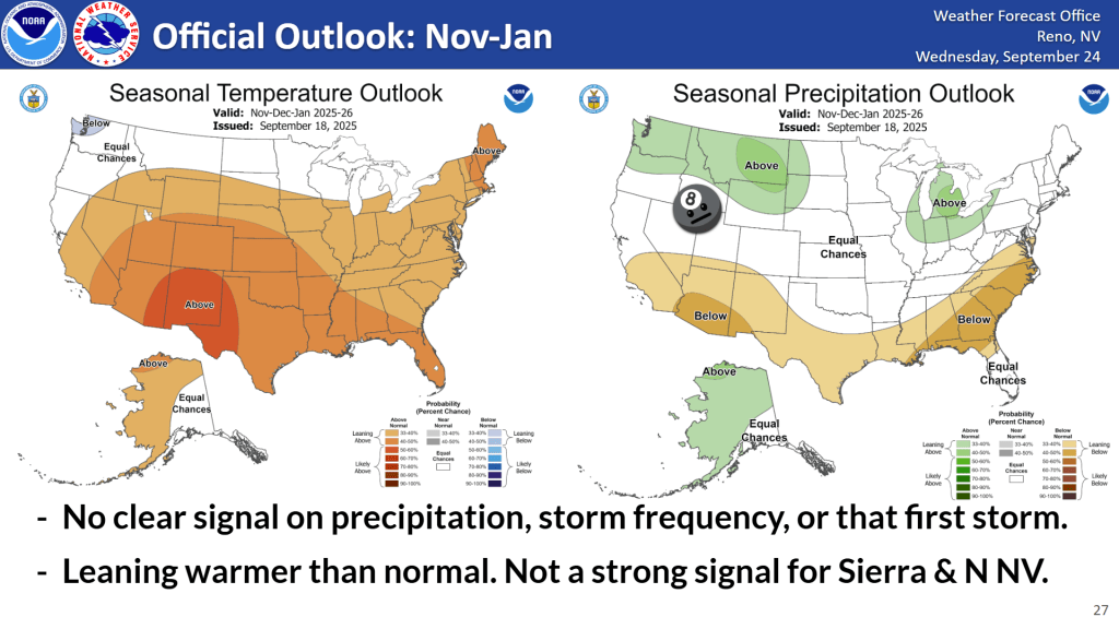
So where does this leave the Central Sierra? Based off current conditions and what we do know, the Climate Prediction Center places the Tahoe Basin in the swath of “anything’s possible” for the coming season.
I would anticipate anything happening this year, but with a lean in expectations towards warmer than average temperatures and higher snow levels. The earth is warming and with a historical mean snow level of 5000′-6000′ in the Central Sierra, there’s not a lot of grace around lake level when the background conditions are 2-3°F warmer with each storm.
There’s plenty of high terrain in the Sierra. With the right timing, knowledge, creativity, and effort, anyone can have a great season in the backcountry, no matter what the seasonal forecast suggests.
The season is wrapping up. Snow at all but the highest elevations is turning into a singular mass of melt/freeze snow while lower elevation zones are burning out completely. Below 7000′, trails in North Lake have reappeared and meadows now budding into delicate green hues. ‘Tis the season of skiing, biking, paddling, (insert mountain activity) all in the same day.
Above 8000′, coverage remains good, especially in shady zones, but surface conditions are sporty. Forest litter covers an ever-wavier snowpack in sheltered areas, while open zones host spring corn or icy refrozen surfaces, depending on timing. If the itch of warmer temps hasn’t lured you away onto the reappearing trails, now’s the time to get into the bigger peaks where the snowpack is largely stable, weather’s calm, and long days facilitate deep missions.
Timing is critical in spring. Depending on the strength of overnight refreezes, mid-morning through early afternoon can host the best corn as snow surfaces thaw each day. Too early and the skiing is firm and chattery. Too late and snow turns to manky, hot mush. Time it just right and the rewards are smooth, buttery bliss.
Weather and forecast thoughts:
The current spring pattern is locked in for the foreseeable future as the great melt out to summer marches forward. Sunny days with stretches of mild temps, followed by brief cool downs seems to be the rule through the end of the month. Since Fri (4/18), overnight refreezes have returned, keeping the corn cycle going each day.
This week, expect warm high temps in the upper 40s and low 50s across the backcountry, with decent surface refreezes most nights. Model suggest another cool down coming in around the end of the work week through next weekend (4/24-4/27), with a chance of some showers. Highs will fall back into the upper 30s to mid 40s from 7-9000′ later in the week.
While it feels like the summer pattern has already arrived, mid-late spring storms are very common, so another shot of powder is very possible looking into early May, especially in the High Sierra and the northern volcanoes.
For now, though, it’s time to enjoy the brief season of “cheeeese-burger” chickadee calls announcing the day, long, buttery descents, creek-chilled beers, and chips and salsa at the car. Long live spring!