0400 wx obs. at 6350′ in Carnelian Bay: 24.8 deg, 74%RH, and 17.8 deg dew point. Calm winds and clear skies.
0530 wx obs. at 8650 Mt. Rose backcountry TH: 12 deg. Calm and variable winds, clear skies.
0600 temp. at 9200′: 28.5 deg. SW winds at 3-5mph. Clear skies.
Backcountry obs.:
As of this morning (1/29), the 10-14″ of light, dry snow from Sun. (1/26) has consolidated modestly into soft, fun, pow skiing. Tracks abound in the Rose zone, but cold temps have even kept tracks fairly soft. Time and moderating temps since the weekend have allowed the ultra light density snow to bond and compress onto underlying crusts and facets. The result is a dampened, softer bottom to each turn than the rough, scratchy feel underfoot from just a few days ago.
On solar aspects and sun-exposed open areas below treeline, expect newly formed crusts to interrupt the powder vibe. Above treeline aspects remains mainly wind-scoured and firm, reflecting the weeks-long snow drought and NE wind events that pounded and scoured out any recent snowfall.
Weather and forecast thoughts:
Big changes are afoot. After a few more days of tranquil weather, the snow drought that has plagued the Sierra since Jan. 4, looks to break this weekend in a significant way. Rounds of heavy rain and snow arrive on Friday, lasting though the weekend and into next week as an AR looks likely to impact the region. Hydroclimate whiplash, here we go again!
Today (1/29) through early Fri (1/31), will be sunny and milder with temps. reaching the upper 30s in most backcountry areas. Light winds and inversions overnight will create lopsided low temps with peaks and ridges cooling off to just at or below freezing, while valleys and depressions chill down to the 10s and 20s.
The big shift to storminess begins on Friday as SW winds and cloud cover increase across the area. Snow could begin impacting areas down to 6000′ Fri afternoon before snow levels start their weekend excursion up to the highest zones in the region (8000-9000′) early Sat. (2/1). Snow levels near 9000′ will persist through Sat., before slowly lowering to between 8000-8500′ throughout the day on Sun.
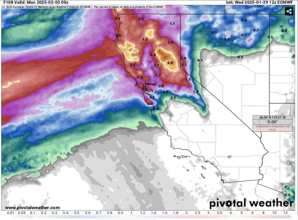
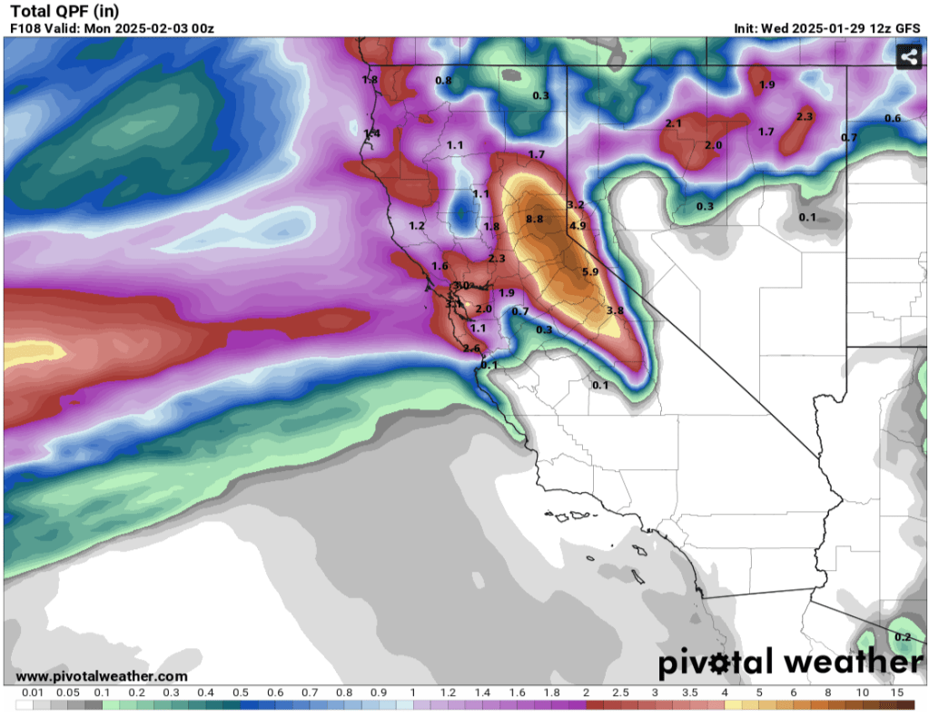
Latest model runs show the potential for precip. amounts between 3″ to nearly 8″ of liquid in the Tahoe Basin through Sun (2/2) at 4pm.
And that could be just the start.
While nearly all of this will fall as rain below 8000′, a couple feet of heavy, dense cement could fall in the backcountry above 8500′ depending on how quickly snow levels begin falling on Sat. night and Sun.
Rain and high elevation snow continue through Sunday, possibly letting up Sun PM through early Mon (2/3), before additional rounds of rain and snow take aim on the Sierra. Snow levels look considerably lower Mon. and Tues., possibly bringing snow down to 6000′.
Much uncertainty remains in the forecast as noted by the above model discrepancy. A shift in the position of the main moisture plume by just 100 miles N or S could make a huge difference in the amount and type of precip. that ends up falling in the Tahoe backcountry.
Either way, dry January has considerably degraded and weakened the backcountry snowpack. Surface snow exposed to prolonged periods of cold, very dry air has faceted into a poorly bonding surface, a future weak layer. A significant avalanche cycle is likely to accompany this round of storms as new loads of rain and snow stress the existing snowpack. On the flipside, a big avalanche cycle followed by significant heavy, wet snow accumulations may be just the recipe to “wash out” and restrengthen the snowpack for the rest of the season. Time will tell.
