Backcountry obs.:
Spring is in full effect across the Tahoe backcountry with fresh snow, sunshine, and variable conditions. This week a cold storm Tues-Weds (4/21-22) dropped anywhere from 4″ to nearly a foot of cold powder across the area, with highest amounts on the NW side of the lake. In the Mt. Rose backcountry, 4-6″ of new dust on crust delivered a surface reset by dawn Weds (4/22), filling in tracks since the last system. The new snow skied cold, light and fast.
Since the midweek storm, sunshine, warm highs and below freezing lows have restarted the corn cycle process just in time for the weekend.
Weather and forecast thoughts:
While most high elevation snow might be in prime spring skiing shape this weekend, an unsettled pattern of afternoon showers and storms, will keep conditions highly variable into early next week. No significant accumulations are expected, however a coating to a few inches of snow and graupel could fall out of any group of showers/storms that get hung up on terrain around the area, especially south of Tahoe on Sat.
Expect highs in the backcountry above 8000′ in the low-mid 40s on Sat (4/25), before falling into the mid-upper 30s on Sun (4/26). On Mon temps will start a steady rebound back through the 40s, edging a few degrees higher each day through the end of the week.
Lows this weekend through the beginning of the work week look to fall below freezing in most areas, promoting surface refreezes each night. This could further aid the corn cycle in areas that don’t receive new snow, or preserve whatever coating falls in afternoon showers.
The culprits behind this unsettled and complicated pattern of late day showers and storms are two areas of troughing in the upper atmosphere and their associated pulses of low pressure: one to the NE and another low coming ashore on the central CA coast that eventually merge late Sat into Sun (4/25-4/26) before meandering off to the east.
These troughs have the upper level dynamics in place to promote rising motions in the atmosphere, creating clouds and precip., as noted in the 500mb vorticity analysis through the weekend.

In addition to the forcing provided by these low pressure systems, daytime heating on the mountains–especially any sunny mornings and early afternoons–will add a convective forcing element, lifting air skyward in growing cumulus clouds. Look for cumulus clouds bubbling up each late morning and afternoon this weekend as precursors to showers and thunderstorms.
In addition to the dynamics, there’s also plenty of moisture across the Sierra to condense out into precip. as noted in the Euro model for mid level relative humidity levels from this weekend through Mon (4/27). Notice the slug of moisture south of Tahoe late Sat into early Sun.
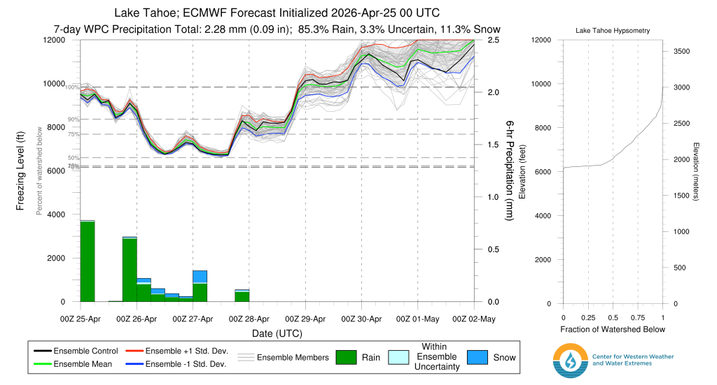
Most of the precip that falls across the backcountry above 8000′ will be snow this weekend, especially late Sat and Sun. Model forecasts for freezing levels snow colder air arriving late Sat which will drive snow levels down towards lake level by Sun morning, before lifting to around 6500′-7000′ by later in the afternoon.
All of the elements are coming together this weekend to create a mixed bag of weather: sun, clouds, snow showers, and even some thunder. Just as the backcountry now has multi-sport conditions, so too will the weather be “multi-impact”.
Looking ahead into next week, the pattern looks to settle down a bit towards the middle to end of next week with sunnier weather and near normal temps reaching the upper 40s-50s by midweek.
