Backcountry obs.:
Rather than fight the weather, I’ve put away the ski gear for the time being and gotten my backcountry jollies on foot, sampling the newly available trail running opportunities through the ever expanding snow-free zones. As of 3/23, continuous, tacky, open trail exists almost uninterrupted below 7500′ on all aspects, and below 8000′ on all but protected NW-N-E aspects along the NE corner of the Tahoe Basin from the Mt. Rose backcountry to Tunnel Creek.
Snowpack starts abruptly around 8000′ on most treed aspects, but is absent on windward and solar faces all the way up to ridgelines and summits. Where snowpack does still exist, surface snow is more reminiscent of late spring/early summer, pocked and littered with forest debris and rotten from multiple nights of poor to nonexistent refreezes. In the trees, pronounced, rolling undulations are growing ever more-prominent as tree wells melt down to the ground, leaving the remnant fins and waves of deeper snowpack in between. Tree skiing is becoming necessary survival/transit skiing after better turns up high.
Above treeline and 8000′, open N and NE facing terrain is in better shape. Despite lows only bottoming out in the 40s, dry air and radiational cooling have promoted marginal surface refreezes on the majority of nights over the past week, creating supportable snow early each morning. By late morning, temps warming into the 50s under direct or slightly-filtered sunshine has overcooked corn into wet mush on most days. But with the right timing and right objective, fun spring skiing is still out there over higher terrain. The snowpack might be hammered and waning, but it’s still hanging on up high.
It’s spring and the backcountry’s primed for multi-sport days. What’s not to love about biking, running, climbing, and paddling in the same day or skiing a line and mountain biking home?
Weather and forecast thoughts:
Anomalously warm and dry — yet less record shattering — weather will continue through the week and coming weekend (3/25-3/29). Highs above 8000′ on the remaining snowpack will climb into the mid-upper 50s each day with lows in the upper 30s to low 40s in a relatively dry airmass. Expect surface snow in forests to refreeze poorly most nights, especially with any cloud cover, while open areas with a clear line of sight to the sky will cool and resolidify more efficiently each night.
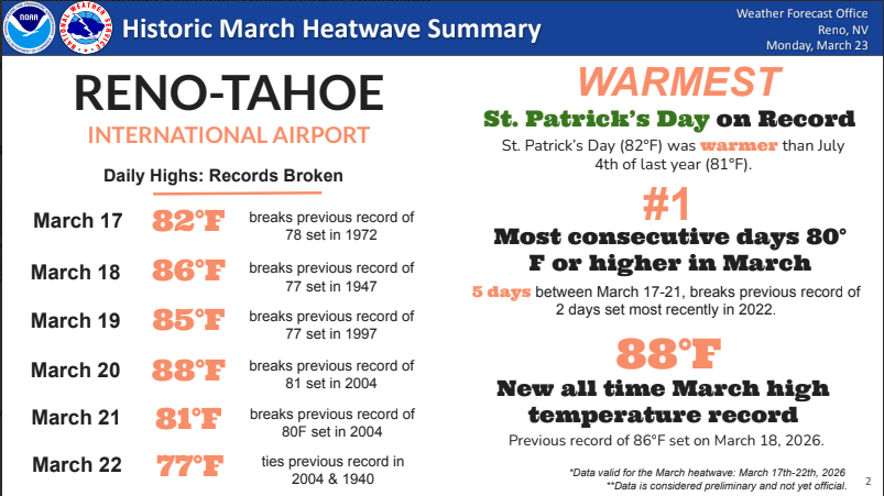
Winter 2026 has been the warmest on record and the past ten days blew away any previous March records by wide margins. Equally notable is that rather than occurring over a day or two, this heatwave has persisted for well over a week–and will continue for another–with multiple waves of extreme warmth. While heat has felt like the norm this season and many folks have already switched their minds to summer activities, it’s worth taking note of the scale of the recent event. It’s truly historic.
On Mon (3/23) NWS Reno put together a graphic summarizing the situation:
The main culprit is the historically strong and resilient ridge of high pressure over the west, directing any and all weather north into Canada. Locations under the ridge bake as high pressure pushes air downward, drying it out and warming it up via subsidence.
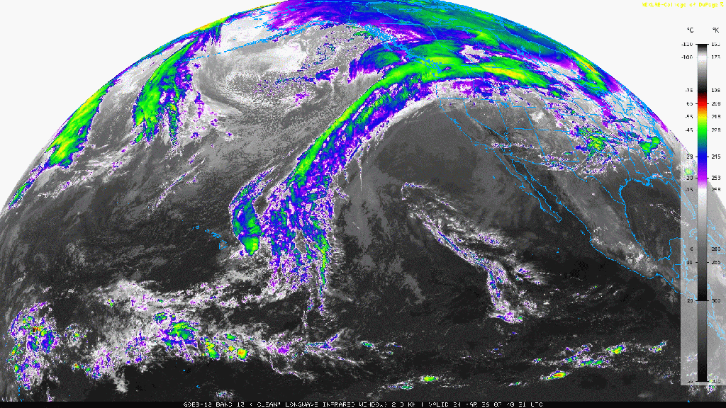
This morning (3/24), the ridge remains locked in place, as noted by IR satellite imagery showing clear skies across CA and the jet stream shunting any moisture northward toward into BC and WA.
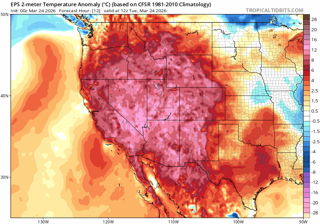
As a result, while not summer-warm, the next week will continue to be 10-15 degree above average as noted by ground level temperature anomalies for the coming week.
But as has happened both in December and after a bone-dry January earlier this season, eventually the pattern breaks. Models over the past few days have started to agree on a pattern shift pushing the ridge eastward and allowing a trough of low pressure to swing in its place. Cooler and wetter conditions look more likely to return by the beginning to middle of next week.
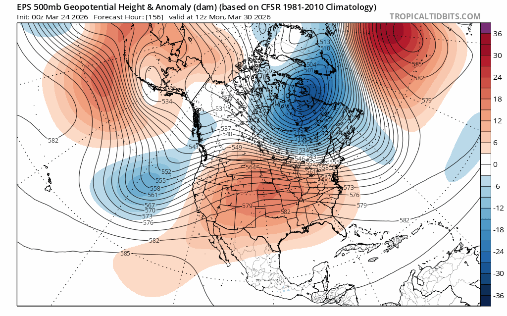
The exact details of the shift will become clearer in the coming days. For now, expect an end to late spring warmth and the return of cooler temps, and the chance of rain and higher elevation snows starting around the beginning of April.
