Backcountry obs.:
The great winter heatwave of 2026 is upon us. Touring inbounds at Diamond Peak at dawn on 3/16, surface snow had barely refrozen near the base area in a protected drainage thanks to overnight inversions. Moving up mountain, snow quickly softened and temps climbed starting around 7000′ and continuing to the summit at 8540′. Light easterly winds and temps in the low 40s greeted me at the summit where snow had barely cooled enough for a weak, surface refirm.
This morning (3/17), low temps and dew points failed to refreeze surface snow, even with evaporational cooling high in the backcountry above 9000′. Temps atop Slide Mountain (9600′) only bottomed out at 46.2°F around 0400. This temperature coupled with 46% RH just wasn’t enough for snow grains to cool and refreeze on their own. It’s March 17 and even at the highest elevations in Tahoe, the snowpack is melting day and night.
As such, expect warm, soft, and slushy snow throughout the backcountry for the foreseeable future. Even after the heat wave’s peak, temps will still be well-above normal, slowing the big melt only marginally. For many backcountry zones between 7000-8500′ where the snowpack was already thin, this event will likely draw a close to the 2026 snow season.
Weather and forecast thoughts:
Sunshine, light winds, and unprecedented warmth will continue through the week and into the early part of this coming weekend, likely peaking on Thurs (3/19). This weekend (3/21-22), the extreme, record-breaking heat fades into much above average warmth (10-15°F above normal) lasting through at least the first half of next week. Beyond next week, some models hint at the return of light precipitation returning, but confidence is low.
This afternoon (3/17) temps reached the low 70s in Martis Valley with mid-upper 60s between 6000′-7000′. In the Tahoe Basin within 100-200ft of lake level, temps remained a bit cooler, only reaching the low 60s due to the cooling influence of Lake Tahoe’s winter-chilled waters. Temps for the remainder of the week will climb even higher reaching the low 70s near and below 7000′ Weds – Fri (3/18-3/20). Temps may remain a few degrees lower near the lake due to the lake’s aforementioned cooling effect.
Lows throughout the week will remain above freezing all the way up to the highest backcountry locations, preventing surface refreezes. Where snowpack remains, it will likely turn isothermal (uniformly 0°C from surface to ground level). Wet snow instabilities and rockfall will become common, especially on sunny aspects and around cliff features each afternoon.
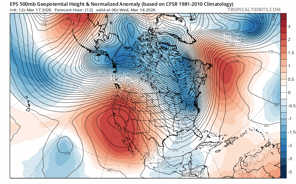
As advertised, the cause of the anomalous warmth is a large, nearly stationary ridge of high pressure that’s creating a summer-like heat dome effect over the American West. As air sinks beneath the high, it dries out and heats up via subsidence, baking away the Sierra snowpack in the process.
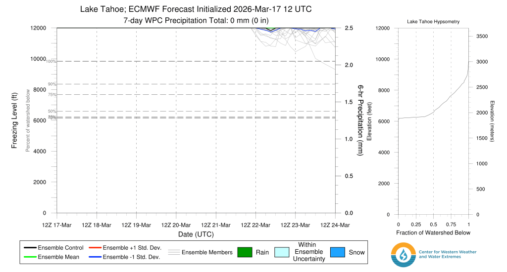
To get a sense of how warm this airmass actually is throughout the atmosphere, check out the ensemble models for freezing levels in the Tahoe Basin. Even the coolest models keep freezing levels above 12,000′ until Sun morning (3/22).
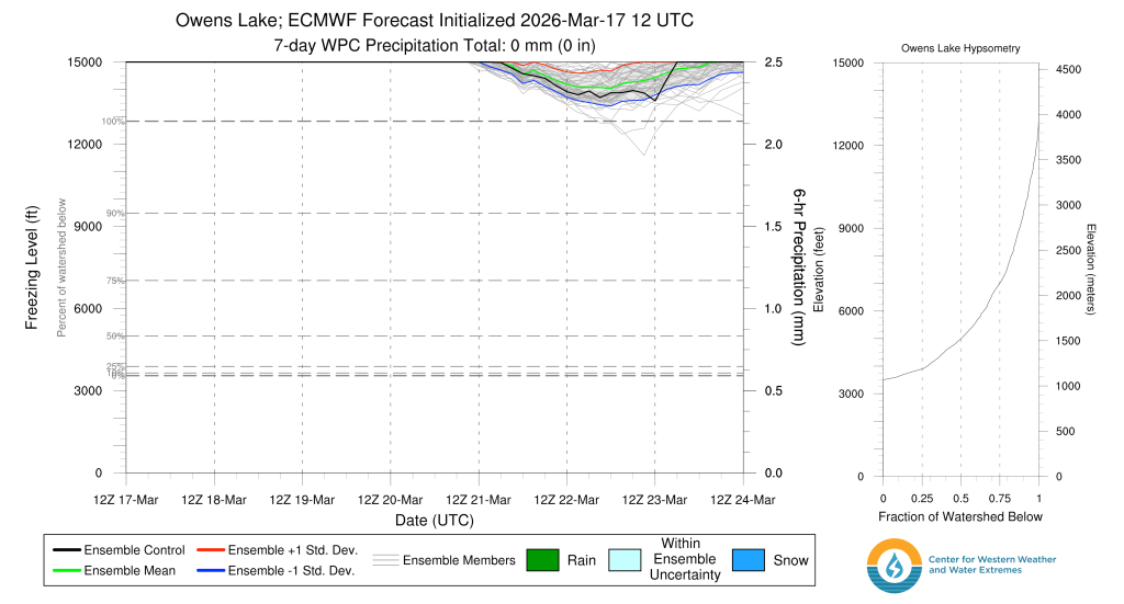
Is there any escape at the highest elevations? No. Even the highest elevations in the Sierra will not escape the summer-like heat. Freezing level forecasts for the Owens River watershed, which includes the Eastern High Sierra from the Palisades to Mt. Whitney, keep temps above freezing even above 14,000′ through at least Sat (3/21).
While the Southern Sierra’s high elevations helped it to fare better through the 2026 snow drought–some areas above 10k ft. received near to slightly above average snowpacks going into March–this week’s warmth will rapidly accelerate melt and promote widespread wet snow avalanches and rockfall, especially in couloirs and along rock faces. I anticipate many High Sierra lines being cleaned out and/or littered with rockfall after this week.
Peering ahead into the coming week and into the start of April, models suggest above average temps retaining the upper hand across the Sierra through the 27th, but to a less extreme degree, with some signs of precip reentering the picture. Relief is a long way off.
So grab your bike, running shoes, or whatever else brings you joy in the warm months. There’s still plenty of fun to be had in the backcountry without sliding on snow.
