Backcountry obs.:
New snow has yet to fall on our haggard backcountry snow pack. Curious to check out what the highly anticipated new snow will fall upon, I toured in both the Mt. Rose area and along the west shore at dawn on Sun and Mon (2/8, 2/9), respectively.
In the Mt. Rose area, melt-freeze crusts exist on nearly all aspects to well above 9000′. N and NE aspects, especially in forested terrain have breakable, yet manageable crusts, while E-S-NW aspects host unbreakable hard crusts. Friday’s brief system deposited up to an inch of thick, lightly wind textured dust atop the old crusts, adding a nearly imperceptible layer of softness to each hard, scratchy turn. Descending from 9900′ on a N aspect, I found surprise pockets of cold, soft snow, but nothing lasting more than 2-3 turns.
One item of note: I discovered 6″+ of facets resting beneath a 3/4 delicate, breakable crust on an open, N aspect around 9500′. Once this layer is covered by new snowfall, it may become a source of instability, reawakening the slumbering avalanche demons.
Along the west shore conditions have taken a much bigger hit from the recent warmth. Gone are the fields of crystalline surface hoar lower down and chalky wind board up high. Between 7000’-8000’, all aspects are baked into supportable melt freeze crusts. Open areas near and just above 7000’ have really taken a hit with the the snow pack shrinking into deflated pillow stage, more reminiscent of late April than early February. Scrubby underbrush and patches of rocks and dirt have begun to reemerge.
What’s more, abundant runoff has kicked off. Open streams proliferate, requiring tricky crossings on unstable, degraded snow. Many streams never really froze from the fall and have been recently reenergized by the warmth-induced melt. Gurgling waters make for a soothing — and simultaneously discomforting—backcountry soundtrack.
Weather and forecast thoughts:
After more than a month without appreciable snow, a doddling storm arrives later today loaded with an appreciable refresh (8-12″) for the Tahoe backcountry above 7000′, especially along the crest. Seasonably cool temps and sunshine return behind the first system for Thurs – Sat (2/12-2/14), before another more impactful storm arrives later this weekend with a solid shot of a proper multi-day dump of Sierra snow.
This morning (2/10), abundant clouds, light to moderate winds, and generally cool temps preface the arrival of the storm. Inversions are gone with temps ranging from upper 20s to low 30s near 6000′ to low 20s along the crest. Precip continues to hold off, however, and will likely not start in earnest until later this afternoon. Tonight snow picks up, especially on the western side of the Basin and along the Sierra Crest, lasting into most of Weds (2/11) before tapering off into intermittent snow showers Weds night into Thurs. Snowfall totals will generally be light around the lake (2-4″), while greater amounts fall on the west shore.
IR satellite imagery early this morning shows today’s system spinning off the Central Coast.
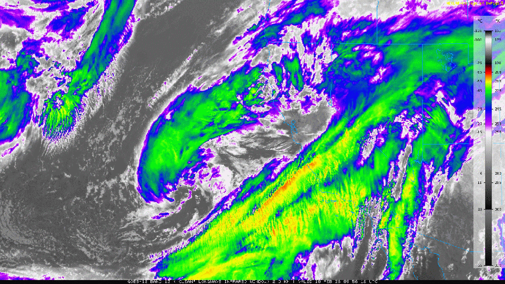
High res models bring the storm east to the CA coastline later today, but then suggest it stalling and spinning about somewhere between Monterrey and San Francisco, sending waves of rain and snow into the Sierra this afternoon through Weds.
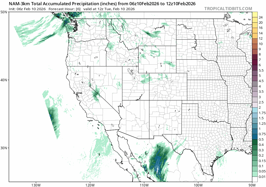
Total liquid amounts through Thurs just before sunrise suggest up to 1″+ throughout the Sierra, likely translating to 8-12″+ of moderately dense new snow above 7000′.
Snow levels for this storm look to start out around 6500′ later this afternoon with freezing levels near 7000′, before falling through the night and into tomorrow morning, then rising back to near lake level throughout the day on Wednesday (2/11).
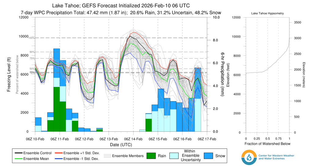
Forecast confidence is moderate in the snow level due to the swings in freezing levels noted above, even during the storm. While there is just enough cold air in place for mainly snow throughout the Tahoe Basin, it is borderline. A warmer than normal Eastern Pacific, the source of the moisture coming into the Sierra, also lingers as a background warm signal for each system, especially for those that linger and spin over the area for a while. The longer a cold air mass resides over the warm ocean, the more opportunity it has to moderate.
The storm wraps up with the exception of lingering showers along the higher terrain for Weds night into Thurs (2/12) bringing light additional accumulations.
Thurs and Fri (2/12-2/13) sunshine and near average temps return with highs in the low to mid 30s and lows in the low 20s across the backcountry.
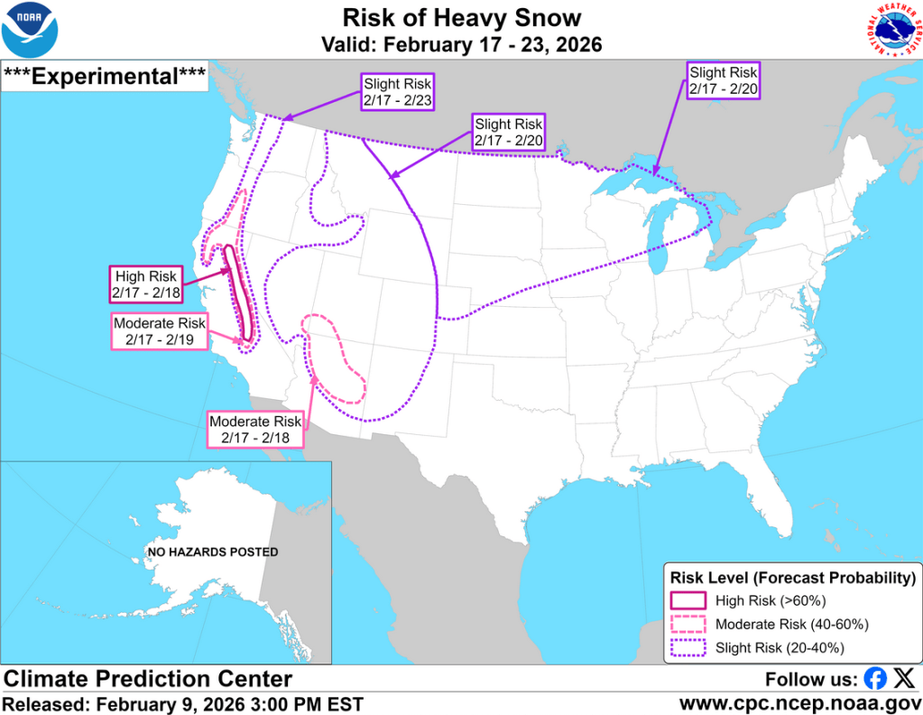
Signs of the next — and likely more impactful — storm arrive on Saturday (2/14) with high clouds and increased winds. Models continue to align around the possibility of a multi-day, cold Sierra storm: a proper “banger” bringing feet of new snow, possibly down to 5000′. The start of the storm has been pushed back to early Sun (2/15), but lasting through the middle of the coming week with snow at or below lake level for the entire storm cycle.
Climate Prediction Center guidance over the past two days has also consistently favored an outcome with >80% of 2’+ for the Sierra above 7000′. A promising sign.
More to come on this storm sequence as it gets closer.
It’s been a long time coming, but the snow ordered weeks ago looks to finally arrive in the coming days.
