1/8 new snow at 6350′ in Carnelian Bay: 4″
Backcountry obs.:
Conditions in the backcountry this week have been squirrely. Early in the week, feet of fresh snow graced the entire region making for midwinter coverage all the way down to 7000′. While the storm system added 2-4′ of new snow, it ended with significant SW winds, creating unstable wind slabs high along peaks and ridges. Temperature wobbles during the storm also created an upside-down density structure within the storm snow. As a result, numerous avalanches occurred in the backcountry on 1/5, including a fatality near Castle Peak.
On Weds (1/7) a tour along the West Shore from 7000′ – 8400′ revealed soft, upside down snow in N and NE facing sheltered terrain, and breakable 1/4″ sun crust atop cold, soft snow on solar aspects. Near the Sierra Crest, wind slabs remained sensitive as evidenced by skier-triggered shooting cracks in steeper wind loaded terrain. While temps hadn’t broken freezing since the previous storm, the snow underfoot skied heavy and grabby. Wide, arcing turns were the best defense against sinking into thick, layered snow beneath.
This whole scenario changed by Thurs. (1/8) as a cold inside slider dropped in on Weds. night (1/7), bringing strong winds, light snow and the coldest temps of the season. Anywhere from 4-8″ of light, dry snow fell across the Tahoe backcountry in the wee hours of 1/8. In the wake of the system, a cold N and NE flow kept temps in teens throughout the day on 1/8.
Light, soft snow remained abundant in the Mt. Rose backcountry at dawn on Fri (1/9). 24 hours after snowfall ended, cold temps in the low to mid teens held a pristine 4-6″ of dry powder, especially in sheltered zones. Beneath the new snow, the dense and stratified snow from last weekend’s storm appeared to be gaining cohesion and density. There’s a less upside-down feel to the snowpack than earlier in the week.
Some light wind effect has textured snow along ridge lines and on exposed N and NE aspects. In some areas this presents as harmless texture, while in others dense wind effect sits atop cold, light snow, or just the opposite: a few inches of cold windblown powder resting atop a slippy, barely breakable wind crust. NE exposed faces and gullies require an attuned powder sniffing nose to find the best, most consistent snow without falling victim to lurking trapdoor wind effect.
Weather and forecast thoughts:
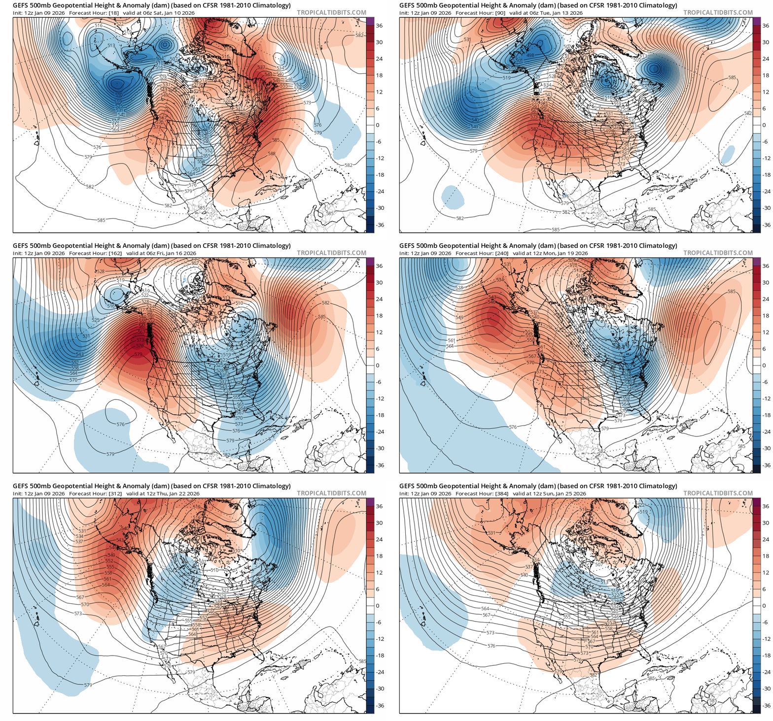
Today starts a warming and drying trend that may last weeks across the Tahoe Sierra. A building PacNW ridge of high pressure is replacing the troughy pattern responsible for the wet systems over the past few weeks. Expect sunny skies for the foreseeable future with temperatures starting cool today (1/9) with highs in the upper 20s – low 30s above 7000′, to moderating a bit each day, then peaking above average (low – mid 40s) by the middle of next week. Strong inversions will likely set up each night with calm winds and clear skies.
Worth noting: In these high pressure scenarios, mountain ridges and summits often remain near or above freezing at night while valleys and depressions can be 10°F or more cooler. In these regimes, very dry air at the upper elevations can help preserve soft snow in shaded areas despite warm temps.
Beyond next week, model ensembles point towards a ridge of high pressure setting up over the PacNW and parking it for a “big sit” until at least late January. Confidence is high in above average temps and little to no precip. through at least MLK Day (1/19).

Beyond 1/20, it’s too early to say. The ridge could shift into the Gulf of Alaska, but the pattern would still remain largely dry. Once again, we swing from very wet to bone dry.
In the mean time, the backcountry has a great, thick base that could weather a dry spell fairly well. Low January sun angles and generally weak solar radiation will also help keep melt relatively slow compared to later in the season. It’s not powder, but dry spells like this can create mini corn cycles on due southerly aspects – and ripping corn is good fun!
Break out the sunnies!