Total snow accumulations at 6350′ from 12/24-12/26: 21″
Total observed snow depth at 8900′ in Mt. Rose backcountry on 12/29 @ 0642: 78.7″
Backcountry obs:
Across the Tahoe Sierra, the Christmas week storm train dropped anywhere from 4-6′ of new snow in the backcountry above 7000′. Because snow levels started high, upper elevations received notably more snow. The backcountry is now set with a base for the season, even in zones down to 7000′. Because much of the snow fell heavy and wet with inches of SWE, then lightened towards the end of the cycle with the arrival of colder air, most bushes, stumps, rock, and other sharky features have been smashed and covered. There’s a solid, reliable base out there. It’s hard to believe that only a week ago people rode mountain bikes through many of the same areas now covered in white.
Cold temps on the backside of the system have only helped set the snowpack and prolong the great skiing. Apart from storm instabilities, the snowpack set up generally right side up and has gained strength since Fri (12/26).
Snow surfaces over the weekend have remained cold, but now host a variable bag of conditions due to sunshine and strong northeasterly winds. In sheltered, shady aspects, cold, light surface snow hosts fluffy turns atop a dense base. Solar aspects have breakable surface crusts worth avoiding and prime NE facing terrain above treeline is now afflicted with variably supportable wind stiffened powder/board, thanks to the recent NE wind event. Massaging your aspect and adding some pop to turns are key to making the happiest lines.
But despite the variety bag conditions, there’s skiable, beautiful snow across all elevations and aspects. What once felt like an impossible luxury is now abundant. And more of everything is around the corner…
Weather and forecast thoughts:
A building ridge of high pressure of Western Canada and the PacNW will bring calm conditions with seasonably cool temps for the next few days. After remaining in the 20s on Sat and Sun (12/27-12/28), temps will moderate into the upper 20s to low 30s above 7000′ for the remainder of 2025, with lows in the 20s each night.
Inversions that developed last night will continue early in the week under the stable air mass. This morning it was 6°F in Martis Valley, 15°F at the 8650′ Rose backcountry TH and 26.9°F on a 9100′ ridge top. Skies through the middle of the week will be generally sunny, though clouds will likely creep back into the region around New Year’s Eve, heralding the arrival of the next system. The coming storm has the potential to bring more rain and snow to the Sierra starting around New Year’s Day and potentially lasting through much of the first weekend of 2026.
Worth noting is the high likelihood of elevated snow levels, especially when the next storm moves in. Currently the system, a cutoff low off Baja, is faffing about pumping warm, moisture rich air deep into the atmosphere in the subtropical eastern Pacific.
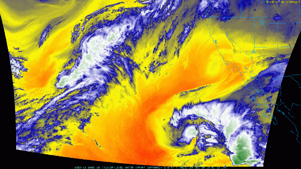
Eventually models depict this low merging with a developing trough extending from the Gulf of Alaska down the West Coast, which will likely introduce colder air into the system.
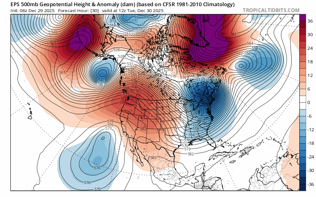
This is a complicated pattern. Over the coming days models and their forecasts will likely shift more than a few times. The challenge is understanding how air masses from two distinct regions will phase and where a storm develops as they meet. Those details will determine how much precip. falls on the Sierra, in what form, and where.
For example, the latest ensembles forecasting freezing levels and precip. for the Tahoe Basin are all over the map. From New Years Day through the first few days of January, there’s decent agreement of precip. and high snow levels initially above 9000′, but quite a bit of spread in both timing, how much precip., and how high freezing levels will be.
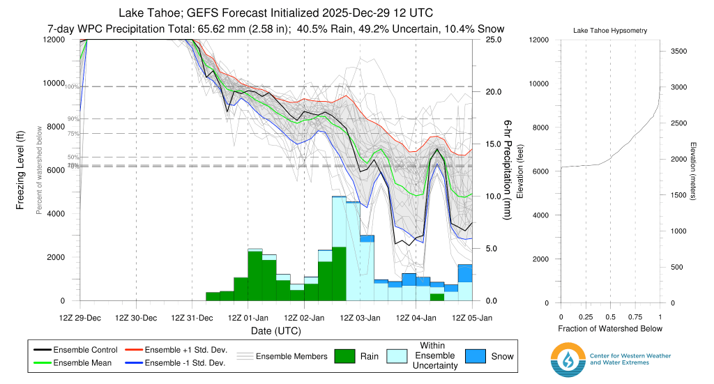
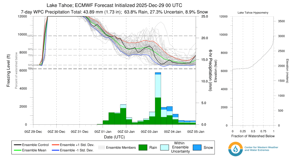
Stepping back from it all, expect 2026 to start with an unsettled pattern dishing out just about everything starting with rain and warmth, then trending colder.
Enjoy the present conditions while they last. The future’s a mixed bag.
