Backcountry obs.:
0515 wx. at 8650′ Mt. Rose TH: 32°F / rain/snow mix / new snow: ~14″
0639 wx. at 9800′: 29.1°F / gusty SW winds between 10-15 mph / new snow: 24″+
Snow has finally arrived to the highest reaches of the Tahoe backcountry. A morning tour today (12/22) in the Mt. Rose backcountry between 8650′ – 9800′ revealed a changed landscape with 14″ of dense, wet cake batter snow at 8600′, while 24″+ now coats areas above 9100′. Gone are the wet rocks, stumps and shrubs, replaced by feet of solid, dense base. This is just what the doctor ordered.
While far from powdery, the new snowpack trades fluffy turns for the security of knowing that a sharp rock or snag is less likely to jump out and eat your legs while laying down a flowy turn. Throughout the tour snow felt right-side up with no obvious instabilities. The uppermost elevations skied surprisingly fast and smooth: a springy cream cheese base coated with cold and zippy powdered sugar on top. Even down low there was little evidence of the warm rain/snow I encountered at the beginning of my tour as colder temps and dropping snow levels had already re-firmed and coated the snow surface upon descent. A real holiday treat!
Weather and forecast thoughts:
The grueling wait for winter is finally ending. Beginning Christmas Eve, multiple rounds of intense snowfall will pound the Tahoe Sierra through Christmas day and through most of Friday (12/26). By dawn on Sat (12/27), guidance suggests that multiple feet (3-5′) of heavy, dense snow will coat the backcountry above 7000′, with 1-2′ of new snow at lake level. The weekend and beginning of next week look quieter with near normal temps (30s at lake level, 20s and low 30s above 7000′).
Today (12/22) snow levels dropped to near lake level during the heaviest precip, but accumulations remained above 8000′ except along the northern shoreline of the lake. This evening showers will diminish from south to north, giving way to a break in the action tomorrow (12/23). Temps tonight will remain steady, then begin creeping upward with the southerly flow ahead of the next system.
Tomorrow (12/23) looks quite a bit calmer than the past few days with partly cloudy skies and the chance of a stray shower passing through. Snow levels will remain elevated, climbing back between 8000-8500’.
The main event looks to arrive in the wee hours of Christmas Eve morning. The storm will start warm with snow levels between 7500-8000′, which start falling around daybreak. Rain and snow will continue through the day changing to all snow by lake level late in the afternoon. Significant accumulations will likely be confined to areas above 7000′ on Christmas Eve.
Once snow levels drop on Christmas Eve, they’ll stay around or below lake level through Christmas, falling even further on Friday (12/26), increasing snow ratios and boosting total amounts. A series of short waves will rotate into the Sierra around a low off the coast near the CA/OR border phasing progressively colder air into a deep moisture fetch creating a setup for heavy Sierra snow lasting through most of Friday (12/26).
Total amounts are still in question with the current spread in the models, but in the past day they’ve begun coming closer together.
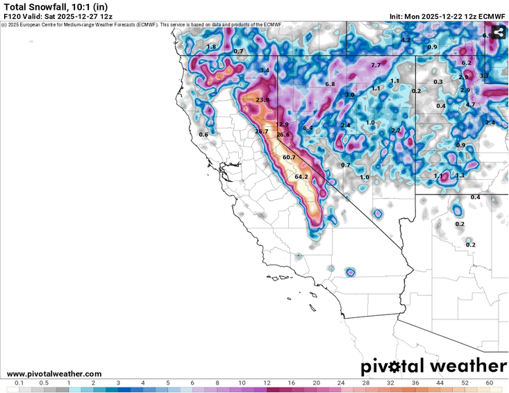
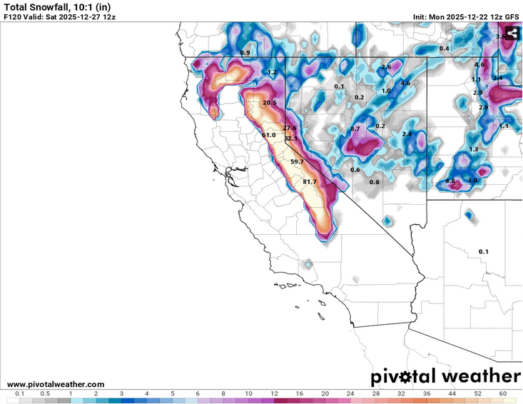
Either way you slice it, snow totals will be measured in feet. A right proper Christmas dump.
Once skies clear on Saturday, expect cool temps and sunshine for the weekend and beginning of next week. More storms could return just after the New Year.
The wait’s officially over. Backcountry ski season is here.
