0400 temp. at 6350’ in Carnelian Bay: 28.0 deg. W/ 78% RH
0515 temp. at 8650’ TH in Mt. Rose backcountry: 21 deg.
0645 temp. at 9000′: 24.9 deg.
Backcountry obs.:
A strong NE wind event over the past few days has created variable wind affected surfaces throughout the Tahoe backcountry: wind-scoured, firm surfaces exist above treeline, crispy refrozen suncrust on solar aspects, and cold, soft, wind-textured snow in sheltered, shady trees and lee aspects. It’s worth getting out and sniffing around.
Mon. morning (1/6), tracks and deep ruts left by the holiday stampede covered the backcountry across Tahoe. However, the inside slider that pushed into the area late Monday (1/6) dropped a skiff of snow, increased NE winds, and cooled temps. Most prime, NE facing areas above treeline had their snow stripped and tossed miles to the SW by the ripping NE winds. What snow didn’t get flung into the Central Valley has been smashed and sculpted into firm windboard and sastrugi along ridgetops and above treeline on N-NE-E aspects.
But fear not! Areas below treeline, even in shaded NW-NE facing areas host cold, oldish snow that remains soft, and in many cases, has filled in the tracks and covered the sins left by the holiday masses.
This morning, cold temps, light winds, and fast, dried-out powder on a spingy base made for gleeful skiing in the Mt. Rose area above 8500′. Many giggles were had.
The dreaded NE winds have been merciful.
Weather and forecast thoughts:
Cold and dry conditions persist for the foreseeable future with no storms yet on the horizon.
Today will be another cool and clear day in the backcountry with highs in the upper 20s to low 30s with light to moderate NE winds.
Tomorrow (1/10) will be the warmest day of the next week with highs reaching well into the 30s to possibly 40 around 8000′ under clear, sunny skies. Should lower humidities hold in shady, sheltered areas, soft snow may persist.
Another inside slider bringing a renewed shot of NE winds and colder temps–but no new snow–returns late Fri. SW winds pick up ahead of the system Fri night, but will turn to N late ushering in a colder, continental flow. Highs in the backcountry on Sat will be brisk, only reaching the mid 20s under sunny skies.
Rinse and repeat for Sun and early next week as another dry, cold, slider brings a reinforcing shot of cold air back to the area with no precip.
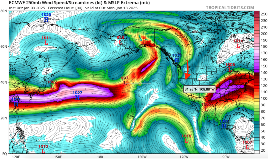
Forecast models are pretty consistent showing a cold, dry pattern locked in through at least mid month. The culprit? A large, reinforcing omega block in the jet stream has taken up residence in the eastern Pacific. Tahoe sits on the far eastern edge of this feature, where the jet stream is angled at the Sierra from the N bringing cold air in on weak, moisture-starved systems.
Beyond next week, the trend in models shows this pattern largely hanging on. However, there are a few that introduce the possibility of some moisture working in.
Nothing lasts forever.
