0400 wx obs. at 6350′ in Carnelian Bay: 32.0 deg. / 48% RH / 14.5 deg. dew point / light and variable winds
0515 wx. obs. at 8650′ Mt. Rose backcountry TH: 31 deg. / light to mod. winds from SW.
0640 wx. obs. from 9890′: 27.3 deg. / Overcast / Winds SW at 8mph, gusting to 12mph
Backcountry obs.:
I headed out this morning for a prestorm conditions check.
Below treeline, sun exposure largely determines snow quality. Shady NW-NE aspects still hold soft, light snow from last weekend’s (1/26) storm. The ultra light snow has consolidated and bonded to the crusts beneath leaving 3-6″ of fluff upon which to turn and giggle. Settling and bonding over the past week has replaced formerly scratchy turns with a dampened, bouncier feel underfoot.
Near treeline and above, frozen, scoured and wind affected surfaces reign on all aspects.
Solar aspects below treeline now host a 1″-2″ thick melt freeze crust that is largely supportable, especially on the sunniest SE-SW slopes. Surface texture in these areas resembles early corn, indicative of the snow drought, but also higher sun angles. Beneath this crust is a loose 2-5″ layer of unconsolidated facets resting atop hard crust.
Weather and forecast thoughts:
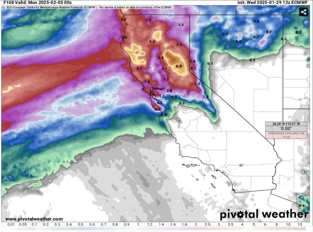
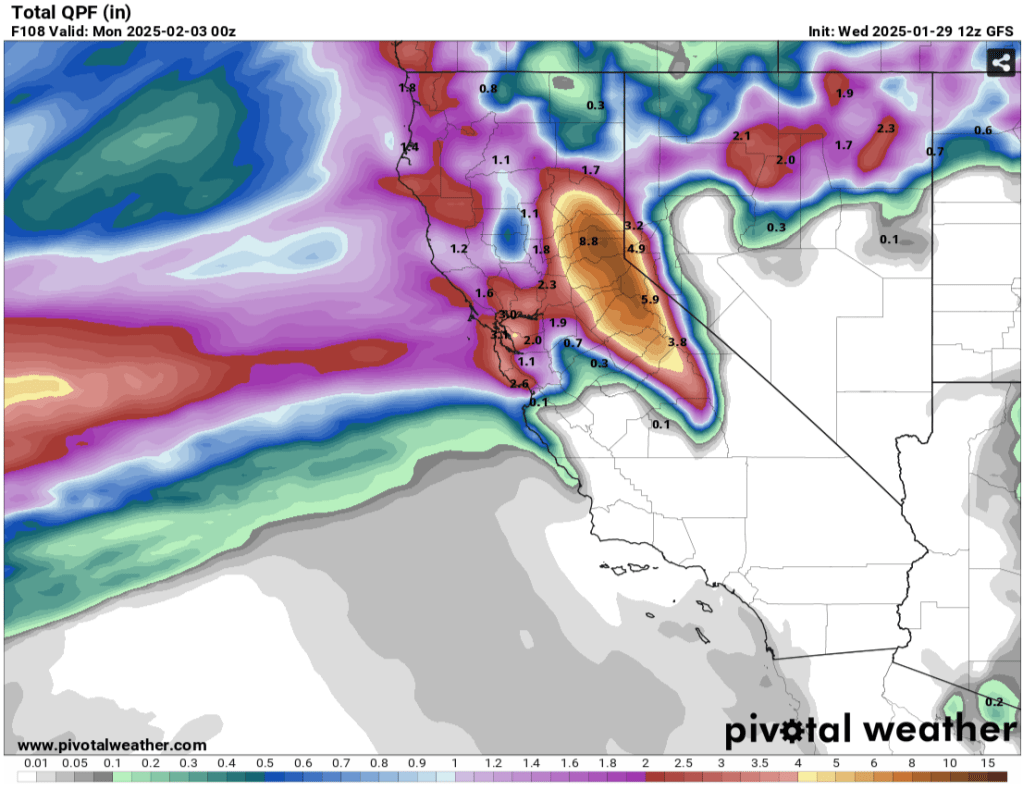
The largest storm cycle of the season to date is right on our doorstep. Heavy precip., high snow levels, and strong SW winds will impact the Tahoe backcountry through the weekend and into Monday. The 50th percentile of models suggests that by Mon. (2/3) several (3+) inches of rain will have fallen below 7000′ in the Tahoe Basin, while 1-3′ of heavy, dense snow is possible, especially above 8500′. Tues. – Thurs., snow levels drop to and below 6000′ as additional rounds of heavy precip. impact the Sierra Mon PM-Tues., and possibly again on Thurs. (2/6).
The action begins mid-late morning today (1/31) with strengthening SW winds and snow showers increasing in intensity. Snow levels will begin below 6000′ and steadily climb throughout the afternoon and evening. By sundown, heavy rain will likely fall up to 7000′ and continue climbing throughout the night.
By daybreak Sat (2/1) the fire hose will be upon us with moderate-heavy rain and snow clobbering the backcountry. Snow levels Sat. PM will climb up to 8000′ on the northern side of the basin, while slightly higher snow levels ~8500′ are likely further south. The deluge continues into Sat. night as snow levels remain high at or slightly above 8000′, likely peaking some time early Sun. morning.
Sun. (2/2), precip. will likely back off as the main focus of the moisture plume shifts to the north. However, very strong SW winds will take its place. Models show high probabilities for 40-60mph winds even below 7000′. Winds over 100mph are almost a certainty on ridgetops. Snow levels will also begin slowly creeping down mountain Sun. into the 7000′ level Sun night into early Mon. morning.
Colder air looks to continue slowly bleeding into the area through the day on Mon. (2/3), dropping snow levels to around 7000′ by the evening and steadily declining thereafter. By daybreak on Tues. (2/4), another round of moderate-heavy precip. comes in, just in time for snow levels to begin flirting with lake level.
Fear not! While round one looks to be a rain producer for all but the highest elevations, colder storms and signficant, snowpack building systems look likely for the middle to end of next week.