0515 temp. at 6350′ in Carnelian Bay: 19.9 deg. w/ 84% RH
Backcountry Obs.:
I took a quick dawn patrol tour in the Tahoe Meadows – Relay Peak area on Sun., 11/17 between 8800-9200′ and noted around 2-6″ of snow cover. Snow was cold, but turning warm and gloppy as temps climbed above freezing, even in the predawn hours. Occasional spritzes of rain even showered down as I skinned through dense fog and moderate SW winds.
A weak, yet cold, storm passed through on Sun night into Mon (11/18) dropping a trace of snow at lake level and 1-2″ above 7k. An attendant cold front left midwinter temps in its wake.
Forecast thoughts:
Late last week, most models indicated a dry, calm pattern for this week. But oh have the tables turned!
Very wet and unsettled weather looks to arrive late tonight (11/19) and last until the weekend–and maybe beyond!–as an AR takes aim on NorCal, bringing multiple waves of heavy rain and snow to Tahoe. Models are in good agreement that the flow of moisture will set up over NorCal, mainly from Tahoe north to southern Oregon, stall there through the remainder of the work week, then drift south.
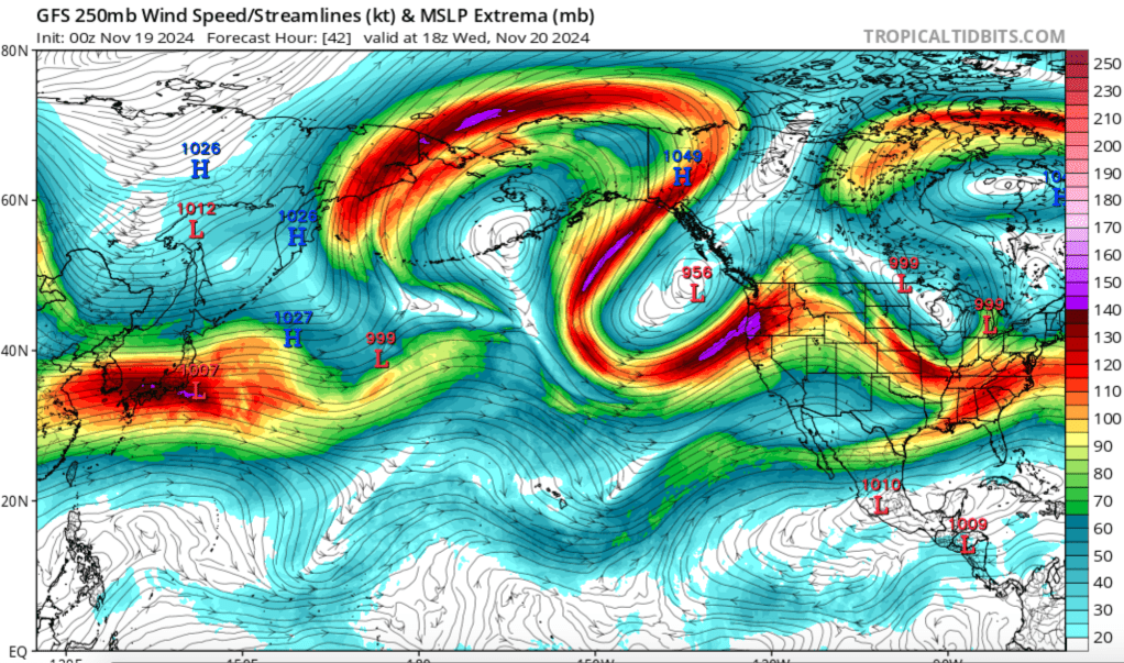
The cuprit? A deep, rapidly strengthening low off the PacNW coast that will steer an intense upper level jet right over NorCal and southern Oregon.
Snow levels will start low tonight in the antecedent cold airmass left in the wake of the Sun-Mon system, then rise with the arrival of a subtropical moisture flow off the Pacific. Light accumulations could fall around the lake tonight, before turning to rain until the weekend as snow levels rise to 8500′-9000′ by Wednesday through the end of the work week. As the AR begins to push south, so too will colder air, bringing snow levels back down into the backcountry for the weekend.
While this storm will bring mainly rain to Tahoe, the mountains could receive a foot or more of dense, heavy, Sierra cement before everything wraps up late next weekend or early next week. And while snow is always preferable to rain, the high snow levels and heavy rain may melt any existing snow below 9000′ and/or saturate whatever remains before the changeover back to snow.
For the backcountry, this could end up being a big positive as it would destroy any weak, faceted old snow that may be lingering in the coldest nooks and crannies, replacing it with a solid base of dense Sierra cement.
At this point, the snow portion of this event is still a long way out. And just as the forecast changed from tranquil to stormy, big changes could sneak in between now and the weekend. Either way, buckle up — and quietly get your gear ready — winter might be just around the corner.
